US National Park Trails That Are Only For Experienced Hikers
For explorers who like to get out there and see the United States, hiking trails present a way to connect with the country's wondrous nature. There are thousands of trails all over America, some far-reaching like the Appalachian Trail, others little more than a short loop from a parking lot designed to direct walkers efficiently to a famed tourist attraction. Hiking is a popular pastime in the U.S., with millions strapping on their boots and hitting the dirt each year. Along the way, these adventurers can see deep forests, shimmering bays, snowy peaks, and rolling plains.
National parks in the United States are a surefire way to encounter some great nature, with trails that are well-maintained and supported by a staff of more than 20,000. Some of those trails are suitable for all hikers, including young kids and those with mobility issues, but others aren't so forgiving. For more advanced routes, only hikers with a habitude of navigating tricky and treacherous terrain should attempt to tackle them.
It's recommended to hike dangerous trails with a companion, but if venturing alone, it's imperative to follow safety tips when hiking solo, such as telling someone your route plans, your time of departure, and the estimated time of completion. Although an admirably low-impact and environmentally responsible way of seeing the world, hiking difficult trails can be extremely dangerous. Every year, the National Parks Service has to respond to thousands of stranded visitors, locating them via search and rescue missions. Let's hope you aren't one of them when attempting national park trails for experienced hikers.
Alta Peak Trail, Sequoia & Kings Canyon National Parks
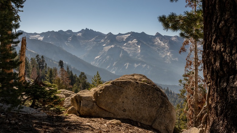
This slash of nature in California is a realm of grand statements — towering mountains, long canyons and valleys, huge caverns, and the biggest trees on the planet. The climb to Alta Peak is tough, and some of it is in high country, with snow still visible even in the summer. However, the payoff is stunning, with vistas of forests, meadows with wildflowers, and ranges of mountains, but the Alta Peak Trail is no simple stroll in the sun. The trail is 14 miles roundtrip in length, with grueling climbs that cover an elevation gain of almost 4,000 feet.
The air at the top is thinner, making breathing and exertion more of a grind. The terrain is often rocky and uneven, though lower sections that pass through woods are green, and hikers will get to see the Foxtail Pine, a relatively uncommon type of pine tree. The best views are toward the end of the hike, near the peak, with sweeping panoramas of mountain ridges, forests, and alpine lakes. This last section is also the toughest, with a final push up a steep incline.
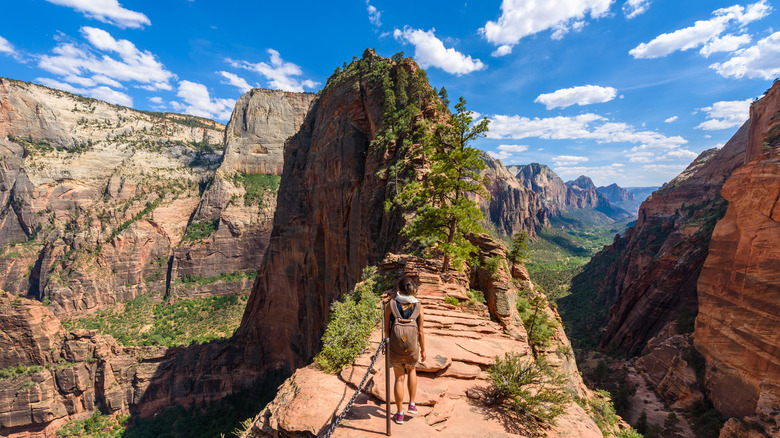
Angels Landing, Zion National Park
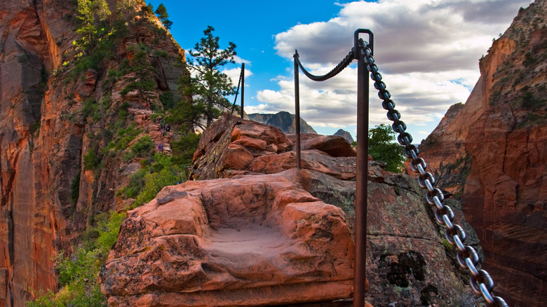
The first national park in Utah, Zion is a place of colors that look like sunset come to life. The peaks and canyons of rocks unfurl in all directions, striated in hues of pink, red, cream, and rust, standing out in stark contrast to the deep blue sky above. Slot canyons majestically carved by nature's forces are tight spaces, while other parts of the park are big and bold, an epic tableaux of geological processes that have played out over millennia. Of the many trails in the park, Angels Landing, which folds into the West Rim Trail, is one of the world's most dangerous trails.
Hikers will need a permit to undertake the route, and then plan for tricky uphills and climbs along chained trails (walk it, and you'll understand why the chains are necessary). A shade over 5 miles in length, the trail climbs 1,500 feet and takes about four hours, with sheer drops and narrow ridges along the way. The views over the top of rock formations are among the highlights.
Avalanche Peak Trail, Yellowstone National Park
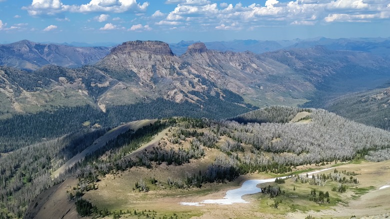
This trail in a vast park that straddles Idaho, Montana, and Wyoming, can take up to four hours to complete, and given the usual weather patterns in this part of the United States, should only be tackled in late summer. Any earlier, and there may still be snow on the trail, and later, in the fall, grizzly bears searching for white-bark pine nuts might appear as company. And yet, even in the summer, the conditions can rapidly change, since the trail is exposed and temperatures can suddenly plummet.
The National Parks Service recommends packing wool hats and gloves, even on a hot summer day. The trail begins with a stretch in the forest, before initiating a steep climb of 2,000 feet over 2 miles. Hikers will find themselves at the bowl below the peak, and then they will need to work up switchbacked slopes and along a slender ridge before hitting the top. Upon completion, views take in the tallest mountains in the park, a breathtaking sight on a clear day.
Burroughs Mountains, Mount Rainier National Park
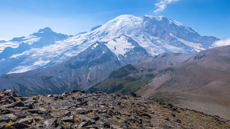
During the cooler parts of the year, the terrain on this arduous hike can look equally barren and imposing. It's also dangerous when ice is present, making climbing the slopes treacherous, which is why hiking in Mount Rainer National Park is often limited to specific months. There are two main peaks for Burroughs Mountains. The first is about a 5-mile trek with a 900-foot elevation and takes about three hours. The second mountain adds just over a mile to the journey, 300 more feet in height, and one more hour of required hiking time.
Getting here starts with the Sourdough Ridge Trail and a pass along Frozen Lake before a taxing climb. The truly hardy might want to attempt the onward mission to the third Burroughs, which entails descending to a plateau before venturing on a new climb along barren tundra and rocky mountains. But if you make the push, you'll be rewarded with epic views of surrounding glaciers and crevasses.
Clouds Rest, Yosemite National Park
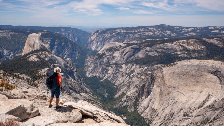
A hike that doesn't appear on some of the park's trail maps, Clouds Rest is a route that heads south from Tenaya Lake and takes in views of some of Yosemite's iconic features. But you'll have to work hard for the reward, as the hike is over 14 miles in length and climbs almost 1,800 feet. At various points during the walk, trekkers will be able to view Tenaya Lake, Sentinel Dome, and Half Dome, the rock that perhaps most effortlessly represents the park.
Some parts of the hike are extremely narrow, with ridges that have long drops on either side, and you'll be elevated enough to sit up among the clouds — yes, you're that high. This hike is best approached on a cloudless day with no sign of snow on any mountains. Among the most punishing sections of the hike is an area of switchbacks, a couple of miles in, that covers over 1,000 feet of elevation.
Fairyland Loop, Bryce Canyon National Park
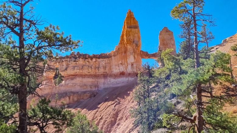
Expect to take between four to five hours on this picturesque hike that takes in the hypnotic hoodoos that are a defining feature of Bryce Canyon. The hike is peaceful, but it's not easy, extending across 8 miles of arid terrain — some on a rim by Boat Mesa, some in canyons that bring Bryce Amphitheater into focus. The hike, as the name suggests, treads a circular route.
Walking it clockwise makes the most sense — the majority of the 2,300 feet in elevation will take place earlier in the hike if you go in this direction. Visitors will see cool rock formations like Tower Bridge in addition to the hoodoos, but they need to plan for the dry air, sparse shade, and an unforgiving, beating sun. The trail itself is easy to follow and in good shape, but the walk can easily be, for all the above reasons, deceptively taxing and quickly debilitating.
Hallett Peak, Rocky Mountain National Park
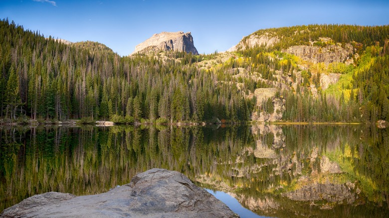
At 415 square miles in size, this park in Colorado is nowhere near the biggest of the national parks, but it certainly packs a lot in. Although it's known as the best U.S. state for skiing, Colorado is also a domain of flowering meadows over green slopes, crystalline alpine lakes, and sharp, jagged peaks. Hikers venturing to Hallett Peak can see it all, including high lakes and barren mountains along the route, which is a 10.3-mile hike that rises more than 3,000 feet.
The trailhead begins at Bear Lake and follows the route to Flattop Mountain, rambling over the Continental Divide as it peers over Dream Lake and Hallett Peak. Continuing on past Flattop Mountain, travelers will find that the trail climbs continuously above the top of the trees when views of more lakes and the glaciated basin appear. The trail can be, at times, tricky to identify, but when you get to the top of Hallett Peak, more than 12,000 feet above sea level, the panorama of peaks and mountain ridges is unforgettable.
High Peaks Trail, Pinnacles National Park
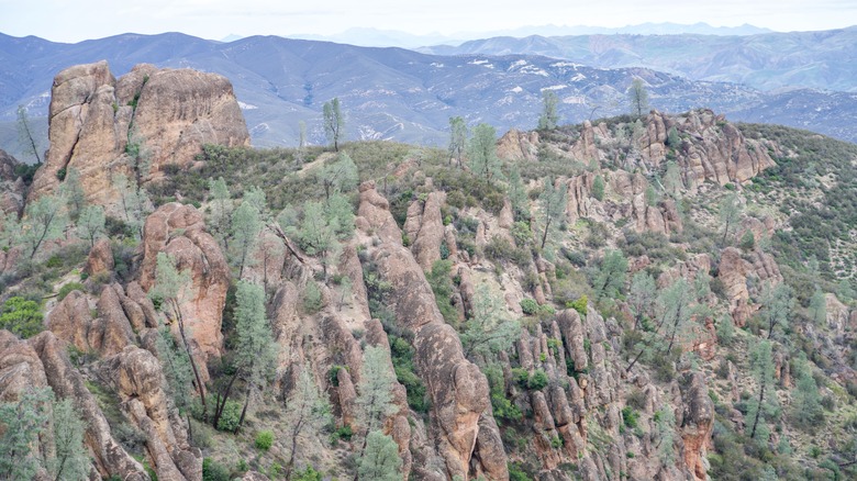
Sometimes combined with the Sycamore Trail or Condor Gulch Trail when starting from the Bear Gulch Nature Center, High Peaks Trail features jagged switchbacks and steep sections. Along the way, hikers can look for condors that sometimes float and swoop overhead. The trails can range from 5 miles and upwards, depending on the combinations chosen, and elevation gains of 1,000 feet or more are to be expected.
The smoothed rock columns of the Pinnacles, with their red-tinged hues, will be on view, as will meadows that fill with wildflowers in the spring. This part of California, in an area of old volcanoes, might seem parched, but it is very much alive with oak and sycamore trees, talus caves, and impressive avian life like eagles and falcons. Hikers will need plenty of water, even for the shorter hike combos. The Mediterranean climate means that most rain falls in the colder months and the summers are dry, with the mercury able to hit 100 degrees Fahrenheit.
Nankoweap Trail, Grand Canyon National Park
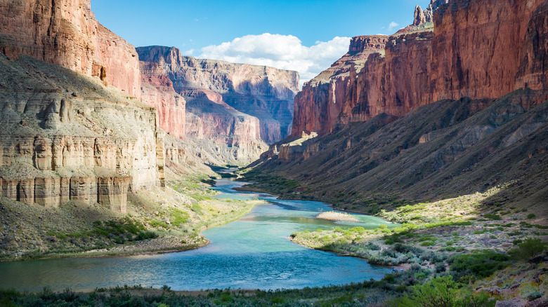
Any walk in the Grand Canyon is likely to bring visitors close to spectacular scenery, but experienced hikers looking to rise to a challenge may consider choosing the Nankoweap Trail, which usually takes a couple of days to complete. On a warm, cloudless day, the trek can be brutal, with large sections out in the open. The National Parks Service dissuades visitors from attempting this hike in the summer. There is almost no water along the trail, and for any traveler with a fear of heights, the exposed sections may be overwhelming.
Travelers should plan to camp overnight at Tilted Mesa or Marion Point on the way down to the river, but to do so, they need to be fully self-sufficient and carry their own supplies, food, and water. This is the toughest of Grand Canyon's hike, descending more than 5,500 feet from the rim to the Colorado River (and climbing that on the way back up), and along the route, hikers will encounter scrubby, spiky bush, slippery shale, and shockingly steep sections.
Old Rag Mountain, Shenandoah National Park
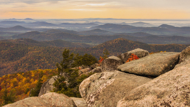
A hike that can be done at any time of the year, Old Rag Mountain is a big draw to this park in Virginia. From December through February, travelers can make the hike to the summit without getting a separate ticket, but for the rest of the year, a pass for day-use to access Old Rag is mandatory. The aim of this is to limit the number of hikers here, with 800 passes issued per day during that window.
There are a few ways to get to the top of Old Rag, but for experienced hikers looking for a bit of adventure, the option that includes some scrambles on rocks might be the most appropriate choice. Whichever route is chosen, plan on walking for a minimum of six hours and climbing at least 1,700 feet vertically. The 360-degree views, looking out over rolling hills and slopes covered in trees, will make the effort worth it, especially in the fall, when the foliage makes for magical views.
Precipice Loop, Acadia National Park
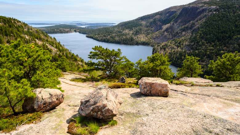
As trails go, this one isn't particularly long, clocking in a little over 3 miles. But what it lacks in distance, it makes up for in its devilish form. Travelers will need to climb up iron rungs on part of this trail. There's a section where the trail rises more than 1,000 feet in less than one mile of terrain. The hike is a test of endurance, willpower, brute strength, and mental resolve, and for the sections that ascend the side of a cliff (queue the iron rungs), not looking down is a good idea.
The rungs are used only for the climb up, and not a smart option for a descent (the parks service frowns on using them to get down). The cliff climb is just one part of this three-hour hike, and other bits include trails of rock, large boulders, slender ledges, and forested slopes. The vistas of Frenchman's Bay from the summit, atop of Champlain Mountain, are inspiring. As a note, you should avoid veering off the trail due to ticks, but these clever tips can help you avoid ticks on your hike.
Primitive Trail, Arches National Park
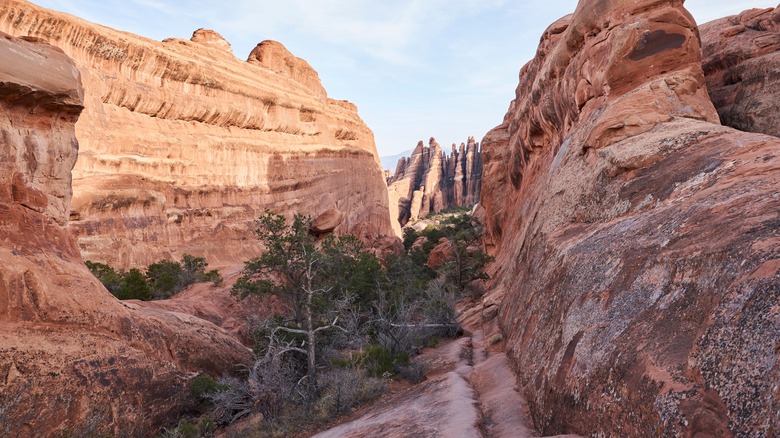
The Devils Garden Trail takes in some of this Utah park's most special sites, including the Landscape Arch and the Double O Arch. It's almost 8 miles in length, with a modest elevation of 286 feet, and can be completed in three hours by a speedy, super-fit hiker. But one section of it in particular stands out for the skill required to navigate it.
Known as the Primitive Trail, it requires crack sleuthing to identify the route (hence the reason for its name), scaling steep inclines, avoiding sheer drops on the sides of narrow ledges, scrambling across rocky surfaces, and even wading in a pool (depending on the time of year). Given the slick qualities of the rocks here, this is not a hike to attempt when it's wet or if there is ice visible — one slip can easily be devastating. Also, it's important to complete the walk during the day; after the sun falls, the temperature in the park can plummet.
Saddle Pass Trail, Badlands National Park
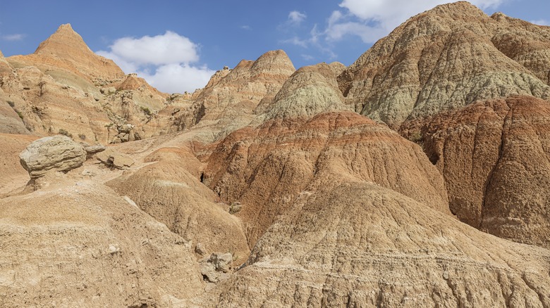
At this park in South Dakota, the terrain is wild and rugged, untamed and untouched. Saddle Pass Trail may be short, less than a mile roundtrip, but the explosive ascent will get the thighs and calves burning. The multi-colored canyons and peaks of Badlands are a result of millions of years of erosion, with water and wind molding the limestone, shale, and volcanic ash into smoothed, curved fragments and formations. The undulating topography is hauntingly beautiful, and travelers can see some of it on this short trail.
The trail climbs up the Badlands Wall, ascending 300 feet in a short span, and delivers views of the White River Valley. The trailhead begins at a short wooden bridge over a creek and winds its way up narrow passages in the rock faces. This can be very slippery and given how steep some sections are, reliable and supportive footwear is essential. From the top, the views seem to go on forever, over plains where rocky mounds seem to inexplicably erupt from the land.
Sliding Sands, Haleakala National Park
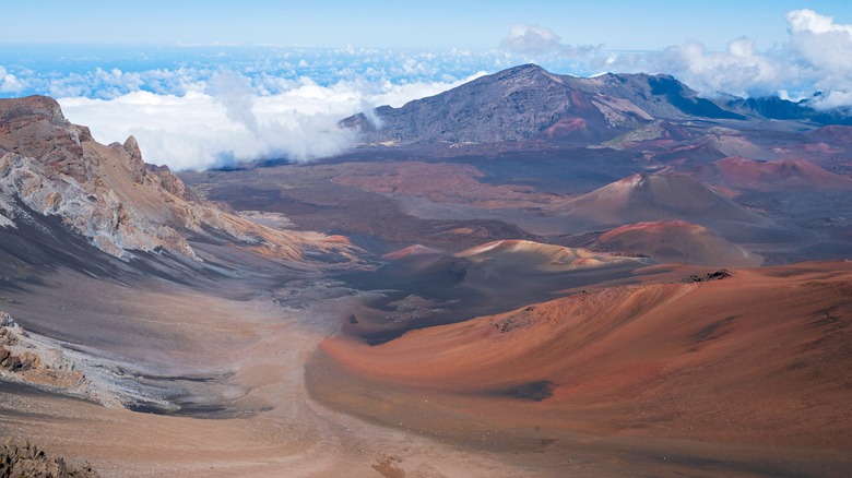
Also known by its Hawaiian name of Keonehe'ehe'e, the Sliding Sands hike is 11 miles in length and takes in a vast array of bewitching colors en route to a crater floor. It's a full-day affair, traversing the valley floor before terminating at a point called Halemau'u, almost 8,000 feet above sea level. Descending to the crater bed is almost 4 miles of the trip, and represents a drop in elevation of about 2,500 feet. Although strenuous, the trail may be one of the best things to do in Maui for experienced hikers.
Perhaps the most visually arresting section of the walk is Pele's Paint Pot, an old lava field next to a cinder cone where the sheer range of colors on the rock and flora make filters on your phone unnecessary. There is also a deep volcanic pit on this hike, called Kawilinau, which speaks to the frisky geologic activity that is a hallmark across all of Hawaii. Much of this hike lacks shade, so hydration and sun protection are critical.
Syncline Loop, Canyonlands National Park
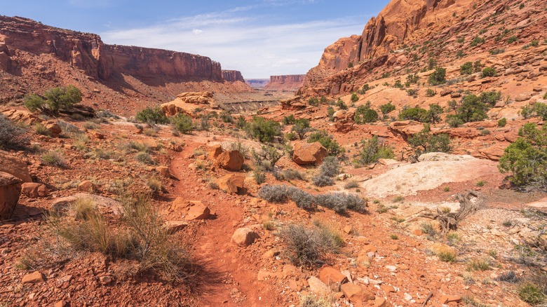
The Utah park is another geological wonder, patiently shaped by the Colorado River and its offshoots. Visitors to Canyonlands National Park can marvel at stoic buttes that spring up from their surroundings and deep canyons that wind and weave themselves as far as the eye can see. Spread across more than 330,000 acres of high desert, the painted rocks also form arches and mesas. The land of Canyonlands splits into four sections, from the busy Island in the Sky district to the wild and off-the-beaten path of The Maze, which is only accessible to four-wheel-drive vehicles.
Syncline Loop bends around a section of Island in the Sky. The 8-mile trail can take up to seven hours to complete, and with a 1,300-foot change in elevation, it's a slog. With sections of boulders where hikers must scrap and scramble and thigh-burning switchbacks, the trail also has the unhappy distinction of being where most rescues are made in Canyonlands.
Triple Lakes Trail, Denali National Park & Preserve
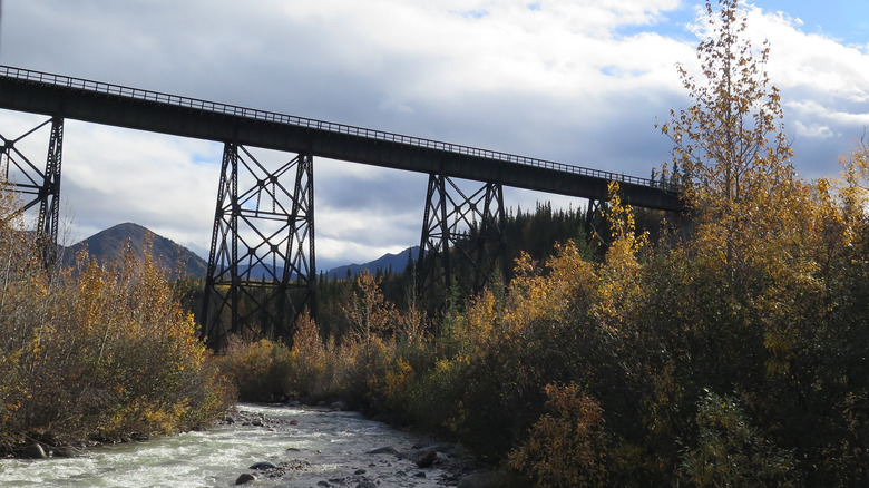
Like much of Alaska, Denali is wilderness through and through. It's a mammoth national treasure, with 6 million acres of terrain and the tallest mountain in North America. The land is pristine, with sub-arctic forest, vast expanses of tundra, and snow-capped peaks stretching for eternity. In all this space, the longest maintained trail in the park is the Triple Lakes Trail, which is still shorter than some of the hikes we've mentioned.
A one-way walk that unravels over 9.5 miles, the trail rises 1,000 feet in elevation. The highest bit is in the middle of the hike, making it an up-down trek, and the hike takes about five hours to finish. Bumbling over creeks, winding through a forest of spruce trees, and then rapidly climbing before transforming into a consistent, gradual incline, the hike is certainly tough. However, the views showcase what Denali has to offer, with vistas of streams, mountains, and alpine lakes.