'America's Most Beautiful Bikeway' Is An Easy Paved Trail Beside Lake Tahoe's Shimmering Beaches
Lake Tahoe boasts the biggest collection of freshwater in the Sierra Nevada chain. The lake offers jaw-dropping views from every angle, over a dozen ski resorts, and road trips filled with mountains and crystal-clear waters. And one little route that circles its northeastern shoreline has been hailed as the most beautiful bikeway in America according to Travel Nevada: the Tahoe East Shore Trail, a multi-mile path that noodles alongside some of the most spectacular shoreline on the Big Blue.
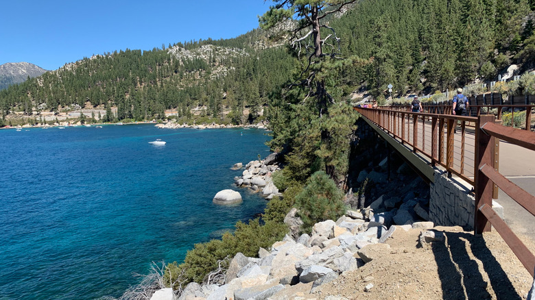
The trail includes 15 lookout points, offers 11 places to access the beach, and comes with ringing reviews — it scored a 4.8 out of 5 on AllTrails with nearly 5,000 reviews, the same on Google, and the same again on trusty Tripadvisor. Totally paved from tip to tail, it's a highly accessible, wide, mixed-use route that's good for cycling, rollerblading, or strolling. You'll move around the utterly beautiful coves and crevices of the northeastern shoreline, gazing out at snowy mountains and turquoise blue waters.
The trail links the sporty residential area of Incline Village to the gorgeous Sand Harbor State Park. It's busiest in the summer but remains open all year round. You can't park directly along Highway 28, though you can find a new clutch of paid spaces at the northern end of the trail, while reservation-only parking can be found at Sand Harbor from mid-April to mid-October. The nearest airport to this corner of Tahoe is Reno-Tahoe International, which sits about 45 minutes by car through the mountains to the northeast.
Incredible beaches along the Tahoe East Shore Trail
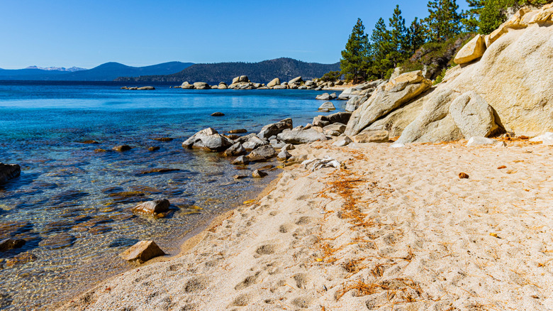
The Tahoe East Shore Trail pushes through some of the most iconic shoreline on the lake. Its southern end is anchored by the wonderful Sand Harbor State Park, which many guides claim hosts perhaps the single finest beach in the whole region — and that's really saying something, since the lake has over 40 mesmerizing beaches! Sand Harbor occupies its very own bent finger of a headland, with a 2,500-foot-long beach on one side and a series of little coves watched over by those trademark Tahoe granite boulders on the other.
At the opposite end of the path, Hidden Beach hardly lives up to its name — it strings below the East Shore Trail with only a narrow line of pines to conceal it. But there are fewer people here than in ever-popular Sand Harbor, plus some more of those quintessential Tahoe boulders, soft sands, and impossibly blue waters.
Between those two beaches, the shoreline gets a touch rockier and more rugged, with small, often empty, inlets instead of long, sandy beaches. Be sure to check out the Memorial Point Overlook, where some exhibits offer insights into local flora and fauna, including fish species.
Divert into the mountains from the Tahoe East Shore Trail
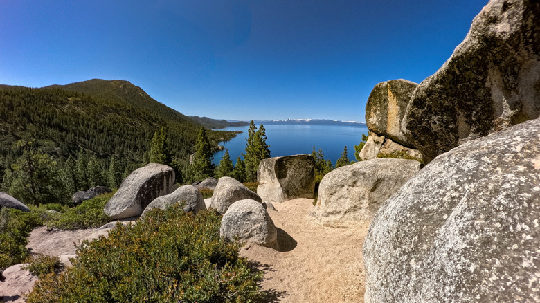
Despite its name, the Tahoe East Shore Trail doesn't always cling to the water's edge. In fact, the first mile of it cuts through the thick evergreen woods on the more mountainous side of Highway 28. At other times, it opens onto incredible observation points where you can take in sweeping panoramas of the whole lake and the distant mountains.
There are also stacks of detours you can do off the lakeshore. Smell the pine wood and get the hamstrings pulsing by adding the 2.6-mile Monkey Rock Trail to your day plan. It begins at the same parking lot as the north end of the East Shore Trail, and ranks among the most popular short hikes in all of Tahoe, largely because it offers a stunning 180-degree panorama of the Nevadan side of the lake.
For even more of an adventure, you can keep trekking higher and higher into the Nevadan side of the Sierra Nevada after reaching the Monkey Rock. You'll need to join the 7-mile zigzagging Tunnel Creek Trail, which dovetails with the epic Tahoe Rim Trail, a whopping great big multi-day loop that weaves through two states and three national forests.