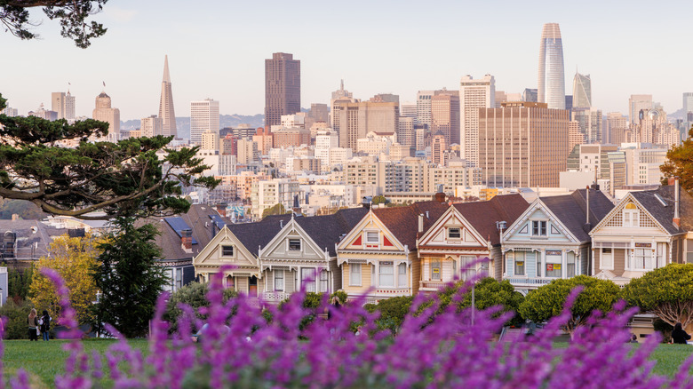
These Are Hands-Down The 5 Best San Francisco Bay Views You Can Get To Without Hiking

They call San Francisco the city of seven hills, but in truth, there are more like 50 named hills peppering this metropolis, let alone whole mountain ranges and soaring mountain peaks to the north and south. The topography really lends itself to lookout points, which can reveal sweeping panoramas of the downtown and beyond. And that's not even mentioning the coastline, which offers a whole other perspective of the city, often framed by the lashing waters of the Pacific Ocean or the iconic Golden Gate Bridge.
The thing is, not every traveler has the time, the gear, or the willpower (no judgements here) to go hiking for umpteen hours to get to some soaring summit viewpoint. That's why we put together this guide, focusing on the finest places to get a panoramic view of San Francisco without having to lace up your boots.
There are some scorchers, too, from a winding scenic highway that skirts Mount Tamalpais on the north side of town to urban parks that offer a perch above the mosaic of blocks in the city center. To come up with this list, we combined the most significant and popular mentions in leading travel media and drew on the first-hand experience of our staff. Each of these viewpoints can be reached by car, and the walking distance from the driving seat to the viewpoint is minimal.
Twin Peaks

Twin Peaks claims the top spot on this list — literally. This outlook reigns as one of the highest points in the whole city, and that means views from every single angle. The truth is that Twin Peaks is one of just three points in San Francisco that exceed 900 feet above sea level, and it is the second-highest point in town, with Mount Davidson claiming the number one spot.
Nonetheless, the duo of summits, which rise right in the beating middle of the San Francisco Peninsula, the headland where the big city makes its home, offer some pretty wonderful views. You're looking at a vision of the soaring steel skyscrapers in the thick of the downtown area, but the scene also includes the Bay Bridge, and, on a clear day, island bird sanctuaries far off in the Pacific Ocean!
All that comes without too much legwork (or, indeed, virtually no legwork at all). That's because you can drive your car all the way to the observation spot known as Christmas Tree Point, which has its own parking lot and coin-operated telescopes for even more in-depth views of the surrounding area. From there, a trail leads a short way up the backbone of not one but two hilltops (hence the "Twin" in Twin Peaks), with the north usually the busier and windier of the bunch.
Panoramic Highway
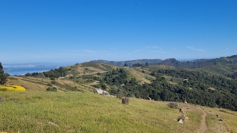
The Panoramic Highway does precisely what it says on the tin: It wiggles its way through the hills of Marin County on the north side of the San Francisco Bay. This utterly beautiful driving route is a must for folks who want to take in panoramas at basically every single turn. I was lucky enough to stay in an Airbnb up here during a visit to San Francisco in the spring of 2025. Simply cruising up to the door revealed vistas of redwoods on one side and skyscrapers on the other.
The highway itself runs for just roughly 10 miles from beginning to end, as it skirts the Muir Woods National Monument going northwards, and then branches westwards towards the sands of Stinson Beach. There are views the whole way along, but there are some specific places where pulling over is a must. Take the intersection of Muir Woods Road and the Panoramic Highway, where a small trail leads to a bluff with head-on visions of the East Bay to the front and the Pacific Ocean behind. Or there's the zigzag in the highway just above the shark-infested Stinson Beach, where you can see mist-soaked cliffs and wave-washed beaches below, while big Mount Tamalpais rises behind.
Be very careful when driving this one — it's notorious for its dangerous road conditions and history of accidents. The whole journey begins just outside of the artsy, bustling city of Mill Valley, where you can stop to fuel up on artisan coffee and sourdough before hitting the viewpoints.
Battery Spencer

Battery Spencer was a regular mention across social media and leading travel blogs, so it deserves a place on this list even without my own personal endorsement, which I wholeheartedly give nonetheless. I recall standing in complete awe of the view here on a blustery May morning. It's not for nothing that the road leading to the viewpoint is regularly used as a backdrop in car advertisements, as it rises more than 500 feet above the waters of San Francisco Bay to offer something very special indeed.
A short walk of just a few minutes will take you from the pull-outs where you leave your car to the side of an old defensive fort that protected the city's harbor from the 1890s until the Second World War. A big clearing on the south side of the fort now gazes straight over the scarlet-tinged metal of the Golden Gate Bridge. Behind, between the chain links and suspension cables, you should also be able to make out Alcatraz Island, and the big modern buildings of the main part of the city, fog willing, of course.
Parking is limited and highly sought after here, so getting in nice and early is a great way to secure your spot. Bear in mind that the road leading past Battery Spencer is one way the whole way, and you'll need to go through a tunnel with decent wait times if you need to loop around looking for a space.
Lands End Lookout

Sitting opposite Battery Spencer on the south side of the entrance to San Francisco Bay, Lands End Lookout lends viewers another fantastic perspective of this unique city. Specifically, this one's about appreciating the point where California and the big city itself make way for the pounding surf of the great Pacific Ocean — it's even possible to spy shipwrecks twisted and crushed on the salty rocks below.
The observation point here now comes with a fully fledged visitor center that opened in 2012. That means it's one of the more weather-resilient spots on this list. Rain lashing outside? No worries. Dive into the exhibits, which tell of the local flora and fauna, and the story of the nearby ocean-fed Sutro Baths, one of San Francisco's most unique attractions — they're a series of seven abandoned saltwater swimming pools left over from a huge wellness development dating back to the 19th century.
There are two ADA-accessible parking lots on offer at the site, which you can reach just off of Point Lobos Avenue. And, just in case you do feel like stretching your legs, this is the starting point of the Lands End Trail, which has been hailed as one of the finest walking paths in the city, what with its glimpses of remote coves, its tree-covered clifftop trails, and its snippets of views of the Golden Gate Bridge in the distance.
Bernal Heights Park
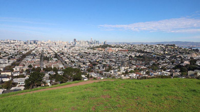
A web of short dirt paths (and a paved route) covers the big bulge of rock that is Bernal Heights Park, revealing some of the finest outlooks across the San Francisco skyline there are. Clear weather permitting, you can gaze out at the Golden Gate Bridge, see San Bruno Mountain to the south, and even spy the Pacific Ocean, though the real joy is getting what feels like a bird's eye view of the downtown's grid-like urban layout.
You will have to walk a little way to get your fix of the panoramas, but the journey is relatively short and sweet. As one former view-seeker put it on TripAdvisor: "Go on a sunny day for the best photos. Great view of the city. Can be a bit windy but worth it." To reach the outlook, drive until you no longer can and then embark on the roughly 2-minute walk to the hill.
Bernal Heights Park is a great place to come to share those views with the pooch, since it's entirely dog-friendly, and your four-legged buddies can even roam off-leash. Parking is available in the surrounding streets. The park itself is open between 5 a.m. and midnight.
Methodology
To build this list of hike-free viewing locations in the great city of San Francisco, we pulled together recommendations from three separate sources: Travel blogs, social media posts, and personal travel experience (based on my own explorations of the metropolis in the spring and summer of 2025). We cross-checked the most frequently mentioned locations across a variety of sources and eliminated any spots that required long hikes or walks to get to.
Finally, I imbued the list with my firsthand knowledge of San Francisco, which meant filtering out some spots I knew from experience that required a bit of hiking to reach. I was also able to add my own recommendations that didn't necessarily appear in mainstream publications, and verify recommendations from third-party sources.