Colorado's Astonishing Road Through The Mountains Is One Of America's Most Dangerous
America is home to treacherous attractions that are sought out by some travelers as much as they are avoided by others. One such destination is Mount Washington's Huntington Ravine Trail, one of America's most dangerous hiking trails. Similarly, people flock to California's Arroyo Tapiado Mud Cave system because they are dark, dangerous, and unique to explore. So it should be no surprise that road trippers still get a kick out of driving the notoriously dangerous Colorado State Highway 82 (CO-82) despite it seeing hundreds of crashes each year, including multiple crash-related deaths.
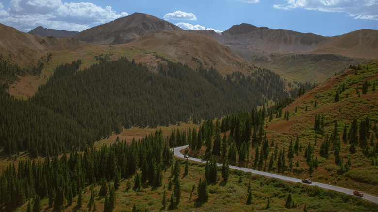
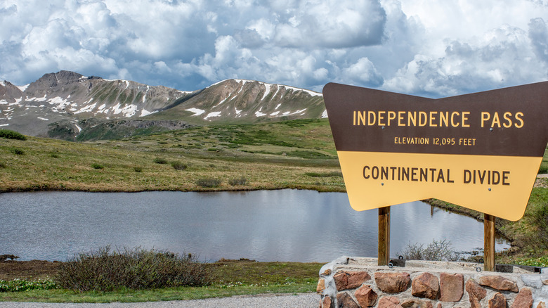
Also known as Independence Pass, this 45-mile section of CO-82 runs between Leadville and Aspen. Seen as more of a mini-interstate than a highway, the driving habits on Independence Pass are creating excess risk for everyone on the road. People tend to speed along this stretch, even when the conditions call for more cautious driving. Drivers under the influence of drugs and alcohol are also a common hazard. Independence Pass is also very scenic, with sprawling mountain vistas capturing aspen forests and undulating valleys. Unfortunately, this eye-catching scenery can often distract drivers, resulting in accidents at high speed.
Despite the risks (maybe because of them), some people see Independence Pass as a Colorado road trip pilgrimage. The alpine highway is over 12,000 feet above sea level and has lookout spots along the way where drivers can pull over and admire the views. You need around 45 minutes to 1.5 hours to drive this section of CO-82, depending on how slowly you want to take it and how often you pull over. This is not the road for unconfident drivers. It has steep inclines, tight turns, and narrow sections with sharp drop-offs. All these can contribute to accidents if you're not careful.
How to drive Colorado's Independence Pass safely
Although accidents happen on CO-82, most locals in Aspen choose it over alternative routes. It's possible to drive this road safely. Just take the correct precautions, watch out for other drivers and cyclists, and don't speed or drive inhibited. The weather is another important factor to consider. Independence Pass closes during winter, when the snow makes it impossible to navigate safely. Between May and October, you should still check the weather before driving to make sure the conditions meet your driving capabilities. The road may be closed anyway if the weather is really bad or if rockfalls are happening.
It's also wise to be aware of the more dangerous spots along this section. Mile Marker 6 near Glenwood Springs is notorious for pile-ups, with over 15 recorded here, including one death. The stretch of road between Mile Marker 4 and 7 is considered CO-82's most dangerous, as it's seen around 30 crashes. Whether you're driving these sections or not, you should always be aware whenever the road narrows or turns sharply around corners. Trying to overtake other drivers in these parts can also result in deadly crashes.
The Colorado State Patrol (CSP) is actively trying to keep drivers safe on Independence Pass. This isn't surprising after over 90 crashes caused serious injuries and five resulted in deaths in 2021. More CSP troopers patrolling the highway may help keep drivers vigilant about speed and other causes of accidents. Without the extra eyes and better driver behavior, "the Highway 82 corridor has the potential to become one of the most dangerous state highway corridors in Colorado," said Captain Jared Rapp, commander of CSP District 4C, to The Sopris Sun. As long as you steer clear of reckless mistakes on your road trip, driving the Independence Pass can be a safe experience.