America's 5 Longest Natural Bridges That Don't Skimp On Stunning Views
When you see a natural bridge, it's almost hard to believe that it wasn't secretly human-made. Seemingly sculpted from canyons and made of long, slender rock suspended over space, natural bridges are bewildering sights. Often safe to walk under or view from a cliffside observation platform, these landmarks make for great scenic hiking destinations. For all their improbability, there are over a dozen recognized natural bridges across the United States, but the ones that are most breathtaking can span more than 200 feet in length.
There's a slight distinction between a natural bridge and a natural arch. As the Natural Arch and Bridge Society (NABS) puts it, all natural bridges are natural arches, but not vice versa. In this way, a natural bridge is even rarer and more unique than a natural arch. The organization defines a natural bridge as one formed mostly by a current of water gradually eroding the space beneath it, leaving just the bridge itself suspended. Other natural arches can form from a variety of forces, including earthquakes, glaciers, and simple weathering.
We ranked formations that are clearly classified as natural bridges, shaped by water currents. These five natural bridges were deemed the longest in the U.S. based on published measurements, using NABS' longest spans list as a baseline. Notably, all are in the Southwest, and most are in Utah, the state also known for having the most natural arches.
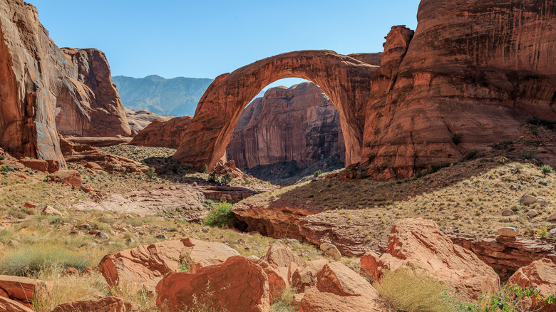
Rainbow Bridge, Utah
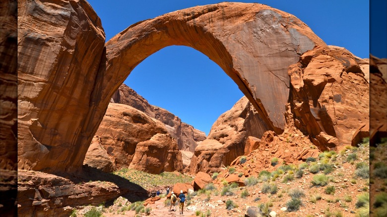
Utah's Rainbow Bridge is the largest natural bridge in America, with data from NABS indicating a total span of 234 feet. As its name suggests, Rainbow Bridge has a graceful curve over a distributary of Lake Powell, one of America's prettiest lakes between red rock canyons in Utah. The bridge, designated a national monument, is managed by the National Park Service (NPS), which provides some fascinating information about its formation and composition. The Rainbow Bridge is made of sandstone and was gradually eroded by a stream flowing through it, which continues to widen and shape the bridge today (eventually, the bridge will collapse due to this flow).
It's possible to visit the bridge by boat or on foot, though boat tours are the more accessible option. According to the NPS, you can book a guided boat tour through park-approved operators such as Lake Powell Resorts & Marinas, about a 7-minute drive from the Page Municipal Airport, which serves commercial arrivals from Phoenix. The tour takes 7 hours round-trip, with a 1-hour stop at the natural bridge. It's also possible to take your own boat on an excursion to the bridge. Just make sure to check the lake's water levels before — when they're low, you won't be able to reach the dock that leads to the bridge, so you'll have to trudge through water or swim to the path.
There are two hiking trails to the Rainbow Bridge, but if you go the hiking route, prepare for a full-day, intense trek through the desert. Both are over 14 miles, according to the NPS. They partially cross through Navajo Tribal Lands, so you need a special permit from Navajo Parks to access the trail.
Sipapu Natural Bridge, Utah
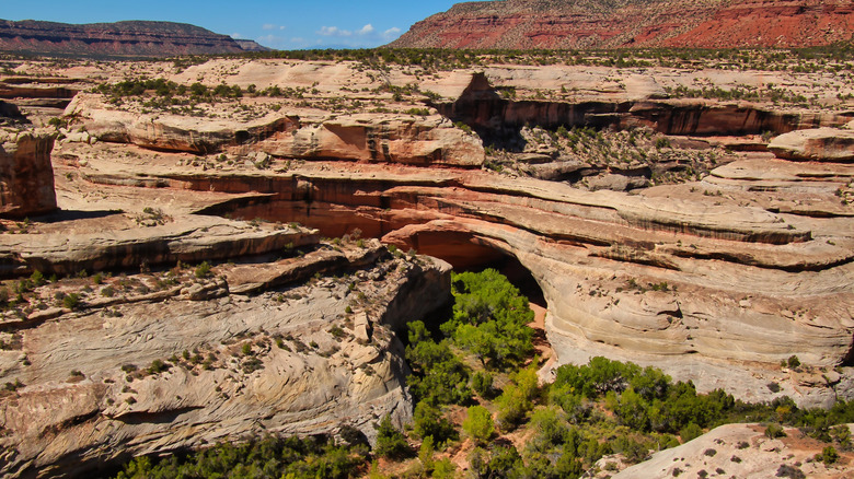
Located within Natural Bridges National Monument in Utah, Sipapu Natural Bridge is the largest of the three bridges in the park. NABS lists its span as 225 feet and its height as around 144 feet (it's also the tallest of the park's bridges). Per the NPS, the Sipapu Natural Bridge could nearly fit the Capitol building's dome within its archway. The bridge was formed from Cedar Mesa sandstone, which gives it a distinct, marbled black-and-tan color.
There's a 1.4-mile round-trip trail leading to the Sipapu Natural Bridge, though, as the NPS notes, it is a very demanding hike. It involves steep canyon scrambling, climbing up rock stairs and wooden ladders, and switchbacks. The benefit of taking this more arduous trail is that you get to walk right under the bridge (note that walking over it, though, is forbidden). There are also some great views along the canyon rim that you have to climb to.
For a more accessible path to the bridge, there's a paved walkway to the Sipapu Bridge Viewpoint, about a 10-minute walk. You get wide-open views of the White Canyon and Sipapu Natural Bridge, though it doesn't get as close to the bridge as the longer trail does. You can reach the site's parking lot by car in about 2.5 hours from the Canyonlands Field Airport in Moab, which offers connections from Denver. You can buy an entrance pass to the Natural Bridges National Monument online.
Snake Bridge, New Mexico
With a span of 204 feet, according to NABS, Snake Bridge is the only natural bridge in the U.S. outside of Utah that's over 200 feet in length. Given its magnificent size and grandeur, it might come as a surprise that the bridge remained largely unknown to the world until 1988, except for several Navajo tribe members. At least one source, a study from the University of California, Davis, cites Snake Bridge as being sacred to the Navajo tribe, associated with a belief that animals that go under it will die.
Crucial to know for any natural bridge chasers: Snake Bridge is hard to visit legally if you're not a Navajo tribe member, since it exists on Navajo Nation land. You can't just hike or drive there as you would on public lands; tribal jurisdiction applies in this case. For any backcountry exploring in the reservation, you need a permit from Navajo Parks & Recreation, and even requesting a permit doesn't guarantee you'll be allowed into the area around the bridge. Plus, you'd also need a Navajo guide. One Facebook user reported visiting the natural bridge, noting that it's a "difficult hike" to the bridge, taking 2 to 3 hours and 9 miles out-and-back, through the Chuska Mountains. The nearest commercial airport is the Four Corners Regional Airport, about a 1.5-hour drive away in Farmington.
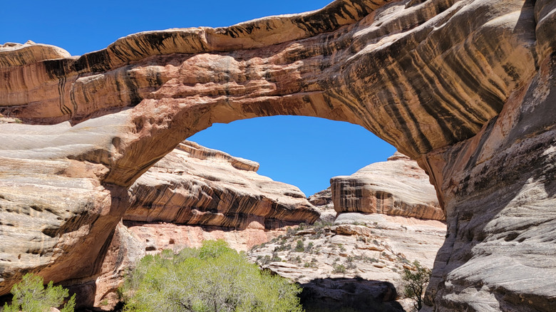
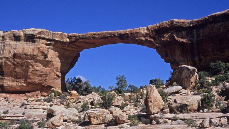
Kachina Natural Bridge, Utah
Kachina is the second-longest natural bridge in Utah's Natural Bridges National Monument. Its span was measured at 192 feet as of 2007, according to NABS. The also NPS notes that it's the thickest bridge in the park, reaching up to 93 feet in some sections. One of the most interesting features of the bridge for history buffs isn't its size, but rather ancient rock art etched into its base. These petroglyphs and pictographs are thought to have been made by the Ancestral Puebloan people who lived here before settlers arrived, and some believe they depict Kachina (a traditional Pueblo performance) dancers, hence the bridge's name.
To get up close to the Kachina Natural Bridge and walk underneath it, take the 1.4-mile Kachina Bridge trail, which meanders down into the canyon the bridge straddles. The trail is primitive and steep, with switchbacks and ladders involved in the climb. It is, however, the only way to get up close to the ancient rock art (just respect the park's policy against touching it).
Another way to see the natural bridge is with the 10-minute paved path to the Kachina Bridge Viewpoint. Though it's paved and has a railing, this path is still very steep. It doesn't get up close to the bridge, but you can easily get an overhead view of the bridge and the surrounding canyon from the viewpoint. As with visiting the other bridges in the Natural Bridges National Monument, you need to buy a pass to get into the park.
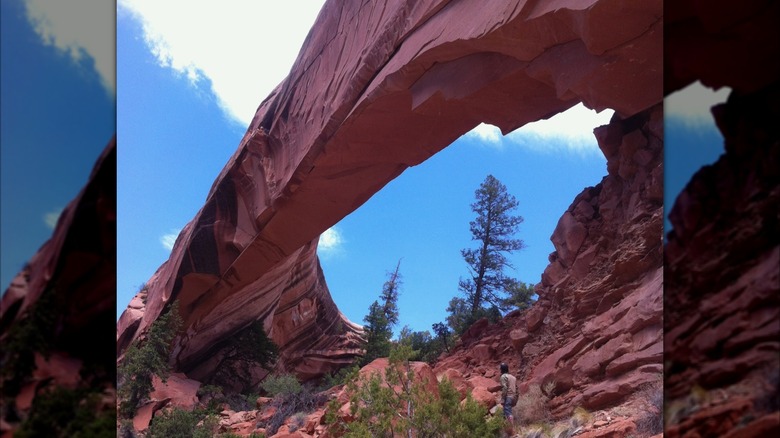
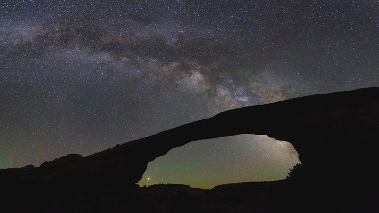
Owachomo Natural Bridge, Utah
The third bridge in Utah's Natural Bridges National Monument, Owachomo, was on the very first list of natural bridges spanning over 200 feet, NABS notes, but it was later remeasured and determined to be 180 feet in length. Though it's the smallest of the park's three bridges, it may be the most photogenic — the NPS claims it's the most photographed. At the very least, it appears to be the most bridge-like, with a slender, symmetrical span delicately suspended. It is likely the most ancient of the park's bridges; its old age is testified by its level of erosion and the changed course of the water current that once shaped it.
The hike to get up close to Owachomo is notably shorter and easier than hiking to the other two bridges. The trail is just a half mile long, though it involves descending some stairs. You'll get to walk under the bridge and see a shimmering pool beneath it.
Alternatively, the most accessible way to see the Owachomo Bridge is via a flat, paved trail to the viewpoint, which takes 10 minutes to hike. At night, the Natural Bridges National Monument is one of the best American locations for stargazing, no equipment needed, and the Owachomo Bridge frequently provides the most striking frame for the stars. Sometimes, the park rangers offer free stargazing programs at the site. You'll just need to buy a park pass online.
Methodology
To rank the five longest natural bridges in the U.S., we relied on the Natural Arch and Bridge Society's (NABS) measurements of bridge spans, backed up by the National Park Service (NPS) and publicly available geological surveys. We also used the NABS' guidance to distinguish between natural arches and natural bridges. Only those considered true "bridges" were included here. That's why, for example, Mantle Rock in Kentucky was not considered — though it's sometimes described as a bridge, it is formally classified as an alcove arch because of how it formed.
We sourced information on how to access the natural bridges from NPS-provided trail information and insight shared by past explorers on Facebook and blog sites. While some bridges are more difficult to access than others (especially Snake Bridge, being on tribal land), we factored in the scenic value that past visitors have praised, from the marbled sandstone of Utah's mesas to the stark isolation of Snake Bridge, which makes the trip worthy of consideration.