Hidden In San Juan National Forest Is A Lesser-Known Mountain Trail To Colorado's Only True Geyser
When you think of a geyser, you probably imagine Old Faithful in Yellowstone National Park, or Strokkur in Iceland, blasting water high into the air. You probably aren't thinking about a geyser in Colorado. However, that's where you'll find the Geyser Spring Trail, which will lead you to the only true one in the state. While Colorado has many hot springs, a true geyser is one that periodically and naturally erupts with both water and steam. This is opposed to one that is manmade, a drilled cold-water well, or a perpetual spouter, which is a hot spring that has water erupting continuously.
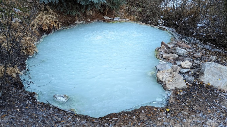
Geyser Spring doesn't have a high spray and throngs of tourists waiting for it to erupt like the more famous ones. In fact, it only has a handful of reviews on Tripadvisor and Google at the time of this writing. Visitors can expect a quiet, hidden spot with an ethereal pool of milky, turquoise water, bubbling as though it were a pot of boiling soup. Hiking to it takes you through pretty meadows and an aspen forest, making for a short but scenic trip.
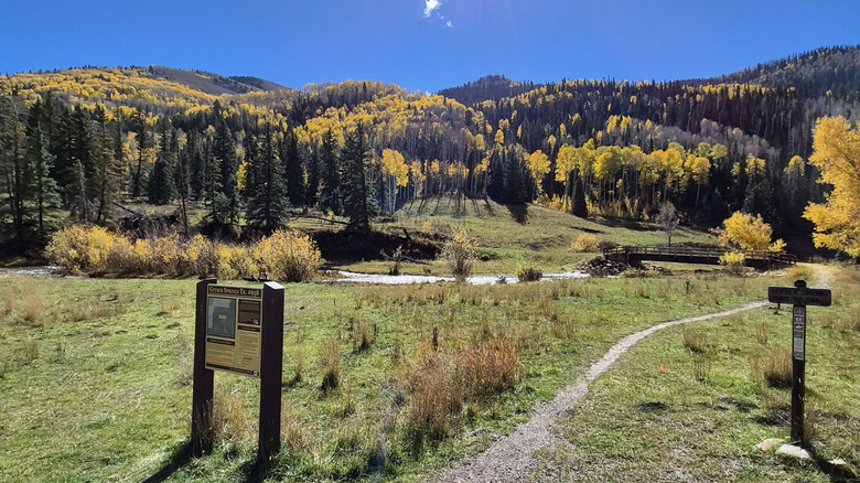
Right in the San Juan National Forest, Colorado's adventure hub with tons of trails, the Geyser Spring Trail is a moderate trek that is only 1.3 miles each way. It will take you to this peaceful little spot, and there is no fee to get in or hike — there's even parking at the trailhead. One previous traveler on AllTrails says, "Pretty easy/moderate trail, pretty views. Saw a small 'geyser' on the right side going up the trail that was bubbling, and the actual geyser was very pretty!" Before packing your bags, it's important to note that there is a safety warning about this geyser and a few other things travelers should know.
Planning your visit to Colorado's Geyser Spring Trail
If you're visiting Telluride, the Geyser Spring Trailhead is around a 1.5-hour drive southwest of the city's regional airport, and a little over 2 miles from the former ghost-town-turned-resort of Dunton Hot Springs. Expect part of your journey to be on a gravel road, so make sure your car is in good condition. Once you're on the trail, you'll cross a newly built footbridge over the West Dolores River. You'll tackle some switchback areas, and then climb about 500 feet on the way to the geyser. As you hike, you'll see some old mining areas, which you should avoid — there are posted signs about it from the Forest Service.
Once you reach the geyser pool, which generally hovers around 82.4 degrees Fahrenheit, you may be tempted to take a closer look. However, make sure you read the posted sign. It explains that swimming and bathing in the water can be dangerous. The geyser releases carbon dioxide and hydrogen sulfide gas, which can be dangerous to breathe in. These gases can make you pass out or even lead to death. It's best to view the geyser from above, and if you don't feel well, leave right away.
You won't have to wait long to see the geyser erupt. It happens every 30 to 40 minutes on average (though it can vary), and the water bubbles for around 12 to 15 minutes. This isn't a frequented hike, so be aware that there isn't that much cell service. Additionally, note that the trail starts around 8,590 feet and ends at around 9,111 feet, so know what to do if you experience altitude sickness on a hike. With a little preparation, you'll be ready to enjoy this rare Colorado landmark.