This Epic Arizona Hiking Trail Just Outside Of Phoenix Loops Through Gorgeous Sonoran Desert Landscapes

If you've ever considered taking on the challenge of a thru-hike like the Appalachian Trail or the Pacific Crest Trail, you'll want to test your planning technique, gear, and stamina first. Most thru-hikes span thousands of miles, run through remote areas, and include long gaps between supply points. That's why a loop trail found in one of America's largest counties could be the perfect test run. It's also a mountain biker's dream, a sanctuary for Sonoran Desert seekers, and the result of careful planning to create a connected trail system that protects the landscape from future development.
The Maricopa Trail, which encircles Phoenix, Arizona, is a 300-plus-mile path that offers hikers easy access to nearby cities for rest and resupply. Thanks to its proximity to a major metro area, you can take on the whole loop or tackle it in sections. While you won't find the solitude of remote trails like the Arizona Trail or the underrated Continental Divide Trail, you'll still need to plan carefully for the challenges presented by Arizona's desert climate so you don't end up dehydrated, injured, or lost without a way to keep in touch with loved ones. Due to the weather, most outdoor activities, including hiking, are not recommended here from April through September. In 2024, officials closed area trails for 45 days during extreme heat to cut down on rescues, so plan your trip to this beautiful area sometime between October and as late as the end of March for the best weather conditions.
Big vision, big county, big trail
Trail systems like this don't just happen — it takes a vision to advocate, find the funds, and build and maintain the trail. In this case, it began in 2000 when the Maricopa County government took the lead on the project to connect existing trails in other jurisdictions. At 9,200 square miles, Maricopa County is larger than New Hampshire, so you can imagine how much coordination it took to string this project together.
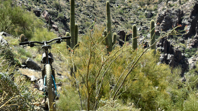
By 2004, Maricopa County and its partners had envisioned the trail and, by 2018, completed most of it. The system links ten regional parks together and builds on a trail concept from the 1960s called the Sun Circle. Today, you'll find paths that are paved in urban areas, rocky in others, and made up of singletrack and doubletrack trails. This route is a mountain biker's dream and is also open to equestrians, hikers, runners, and wildlife watchers.
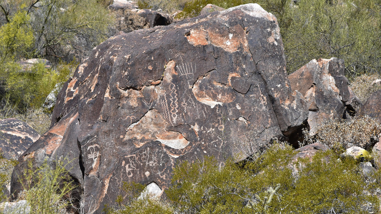
When you picture Arizona, a brown, bleak desert might come to mind, but this part of the state features diverse terrain, including petroglyphs, running water, a lake, washes, man-made canals, mountain views, and, of course, the iconic saguaro cacti. If you're lucky, you might encounter a seasonal waterfall in the White Tank Mountains along the western section of the trail. As with many parts of the Arizona desert, you may also come across less scenic things, like illegal dumping. That's part of why this trail exists — to help more people appreciate and take care of this beautiful space, so be sure to leave no trace of your own journey behind.
Logistics and landscapes
How long it takes to complete the trail depends a lot on your stamina and planning. If you can cover 30 miles a day, you might finish in five days, but because some sections have limited water sources, it could take much longer. For example, outdoor adventuring YouTuber SuperClassy Adventures completed the trail in sections over the course of 20 days. Careful preparation is essential to ensure access to food, water, and shelter throughout your hike.
If thru-hiking or section hiking isn't your thing, consider participating in one of the organized races held on the trail for a sample of the terrain and epic views it presents. Mountain bikers can take on the Prickly Pedal, a 36- or 15-mile race held in February, a beautiful time to visit the Valley of the Sun. The course winds through Cave Creek and ends at Lake Pleasant. Proceeds from the ride go back into the Maricopa Trail + Park Foundation to support maintenance and preservation. Trail runners and walkers can sign up for the Cave Creek Thriller in October, with distances ranging from a 5K to a 50K.
If this sounds like your kind of vacation, your best option to get there is to fly into Phoenix Sky Harbor International Airport. From there, rent a car or take a rideshare about 40 minutes north to Cave Creek, a town known for its Old West charm and vibrant arts scene and a great place to start your adventure.