This Remote Canyon With Saguaros Is One Of The Only Places In Arizona Where You'll Find A Surprising Native Tree

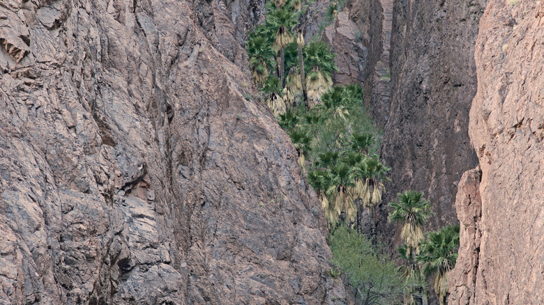
You absolutely expect to see saguaro cacti in Arizona — after all, more than half of the Southern part of the state lies within the Sonoran Desert. But in one remote canyon in southwestern Arizona where saguaros dot the landscape, the real star of the show is something you might expect to find in neighboring California: a grove of native palm trees tucked between rugged cliffs in the Kofa National Wildlife Refuge. It's not a mirage or the work of landscapers. These California fan palms (Washingtonia filifera) are believed to be the descendants of the only naturally occurring palms in Arizona, likely left behind from a cooler, wetter climate during the last Ice Age. While palm trees are a common sight in cities like Phoenix and Tucson, those were planted by people. The ones in Palm Canyon are wild, rare, and still standing. In fact, they're thriving in a shady, protected crease of desert rock that you can hike to today for a glimpse of the past.
The Kofa National Wildlife Refuge is named after the King of Arizona Mine, which was the largest gold producer in the area from the late 1800s through 1910. The region received its first layer of protection in the 1930s, thanks in part to Boy Scouts, who raised awareness about the desert bighorn sheep nearly wiped out in the area at the time. Since 1990, more than half a million acres of the refuge have been federally designated as wilderness for further protection. This means the landscape is left almost entirely to the wildlife that calls it home. Visitors can hike and camp here, but pay special attention to signs as there are areas where vehicles and bicycles aren't allowed.
West Coast wonders await in Palm Canyon
The southwestern corner of the 48th state is sometimes referred to as Arizona's "West Coast," thanks to the Colorado River marking the border with California. Here, towns like Yuma, the sunniest place on Earth, and "Arizona's Playground," Lake Havasu City, are gaining attention as top travel destinations. When summer temperatures are scorching, being near water is a major draw. But for this particular adventure, it's best to visit when the weather is cooler, from October to April. That way, you can take your time and linger a bit longer. You'll take a seven-mile dirt road to the trailhead, so a high-clearance vehicle would be handy here. Many of the reviewers on AllTrails.com say a car is fine for the drive, but it is rocky and bumpy.
Once you park at the trailhead, look for the sign marking the start of the Palm Canyon Trail. The trail is short, about half a mile one way, but it climbs steadily. Sturdy shoes are recommended, and gloves may be best for the final section, where you may need to scramble over rocks.
If you're hoping to photograph the palms, plan your hike for mid-day, when the light reaches into the canyon. The rest of the time, the palms are in deep shade, just one of the factors that helps them survive here. At the viewpoint, you'll see the California fan palms growing in a narrow corner of the canyon. It's a surprising place for them to exist. Palms require water, and there isn't much of it in the open desert. This canyon holds onto just enough moisture in its shaded crevices to support them. You'll also notice small bushes with holly-like leaves along the trail. This is Kofa Mountain barberry, a rare plant found only in this part of Arizona.
Peace trails and history near Palm Canyon
You can begin your journey in Yuma, which is about 90 minutes from the trailhead and home to the Yuma International Airport. But if you'd like an earlier start, consider staying in Quartzsite, roughly an hour away. This small town offers budget hotels, campgrounds, and RV parks, and it serves as a home base for many off-roaders tackling the Arizona Peace Trail, the largest off-highway vehicle (OHV) loop in America. If you're visiting during peak season, you'll want to arrange accommodations in advance.
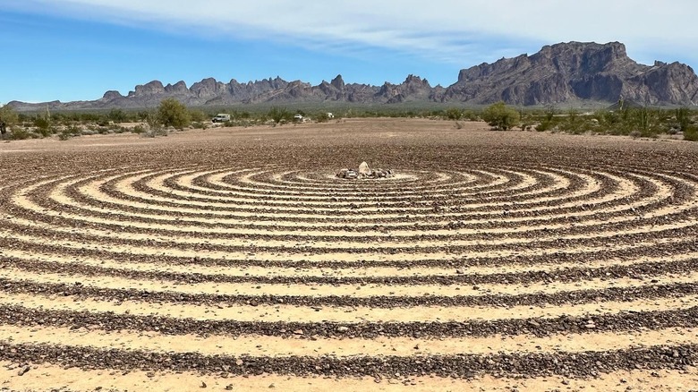
Aside from the hike, there are also several interesting stops nearby. Just about four miles from the Palm Canyon Trail, you'll find a spiral labyrinth open to visitors. It's not a historical spot, but a surprising thing to see out in this remote place. You may also be surprised to learn that this area played a role in World War II. In the 1940s, General George Patton used the refuge's rugged landscape to train troops who were deploying to North Africa, which shares a similar landscape and climate. Even today, unexploded military munitions are occasionally found on the refuge. If you come across something unusual, back away immediately, note the GPS coordinates, and report it to the U.S. Fish and Wildlife Service.