Colorado's Scenic Byway Winding Along Stunning Canyons And Historic Towns Is Far Off The Tourist Radar
People who love a good old road trip are sure to enjoy the Centennial State. There are routes there that cruise over the ridges of the Rockies, and others that delve into the heart of Colorado's Gold Rush country. In fact, there's a whopping 26 scenic byways in this ultra-scenic territory. They include some legendary routes — think one of America's prettiest roads on the Million Dollar Highway and the essential mountain journey of the San Juan Skyway, to name just two. But there are also more off-radar byways, like the wild Unaweep Tabeguache of western Colorado.
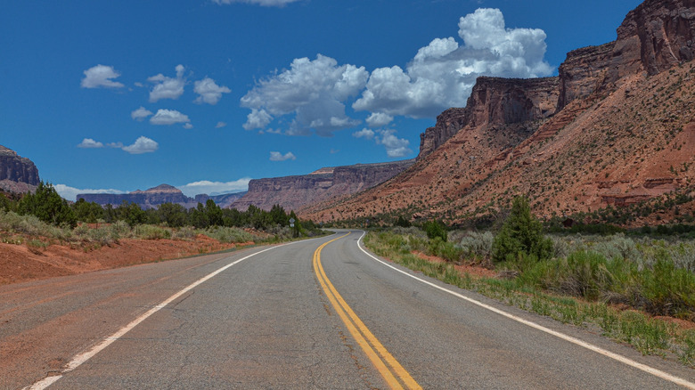
Curving in a C-shape through gorges, dried-up waterways, and soaring plateaus along the Utah-Colorado border, Unaweep Tabeguache is a 133-mile odyssey that showcases some of the state's rawest, most rugged, most untouched scenery. It's packed with visions of cathedral-like mountains that glow rust red under the sun and is framed by snow-dusted peaks on the horizon. It plummets into sheer-cut canyons here, and then drifts into charming small towns and old mining camps from way back when there.
If all that's got the explorer in you ready to burst out, you'll want to make your way to Whitewater, the northern start point of Unaweep Tabeguache. The good news is that it sits plum on Highway 50, just 15 minutes outside of western Colorado's largest city, Grand Junction (itself a fantastic wine and hiking town). You can fly right into the Grand Junction Regional Airport from cities like Denver, Dallas, and Salt Lake City. Alternatively, the drive across the breadth of the Rocky Mountains from Denver will take about four hours total.
The incredible canyons of Unaweep Tabeguache
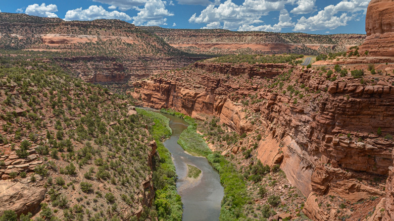
Perhaps most of all, the Unaweep Tabeguache is a journey through the fascinating geological past of Colorado. Canyons dominate the route, almost from start to finish. They erupt along the Dolores and the San Miguel rivers, where you'll witness how the gurgling waters have chipped huge clefts in the sandstone monoliths over the course of thousands of years.
The canyon on the Dolores River is one of the most jaw-dropping sights you'll encounter. It's actually the second-longest river canyon in the country, unfolding in a majestic display of perpendicular stone walls that rise straight from the water below. In big snow years, it's a haven for whitewater rafters, peppered with multi-class rapids. You should also keep watch for curious creatures — bighorn sheep, river otters — as you cruise past.
The route begins in grand style, too. As you join Highway 141 just outside of Whitewater, the landscapes are quickly claimed by the Unaweep Canyon. It's a rare wonder, with two rivers flowing in opposing directions at its base. Later, as the byway skirts through the town of Norwood, the mountains and the highlands really come into focus. This is a remote settlement, perched 7,000 feet up. It's even possible to spot the behemoth fourteeners of the San Juan Mountains marking the skyline from its streets.
The Unaweep Tabeguache is a byway rich in human history
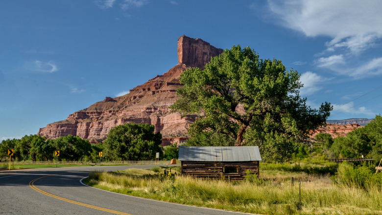
The human story of these canyonlands is almost as enthralling as their geological past. The Unaweep Tabeguache sweeps past some incredible cultural relics, including millennia-old pueblo ruins and petroglyphs, leftovers from the mining booms of the 1800s, and a series of charming small towns as well.
Be sure to pull over at the lookout point for the Hanging Flume in the area of Uravan. There, you can stand and survey a series of timber struts jutting straight from the red rock of the Dolores River Canyon. The half-ruined structure was built to service the gold-hungry miners of Telluride back in the 1880s, and runs for 13 miles along the cliffs.
At another point in the drive, you'll encounter the haunting remains of Driggs Mansion. Once a sprawling abode with multiple rooms, it was given over to the elements in the early 1920s, leaving just the bare rock stacks seen today. That's certainly not the only abandoned piece of civilization, either. There are multiple ghost towns dotting the route going west on Highway 141, as well as the deserted town of Uravan further south, where uranium used in the Manhattan Project was mined throughout the 1930s.