Wild West Sagas And Pioneer Tales Are Mapped Out On This History-Steeped Scenic Byway Across Nebraska
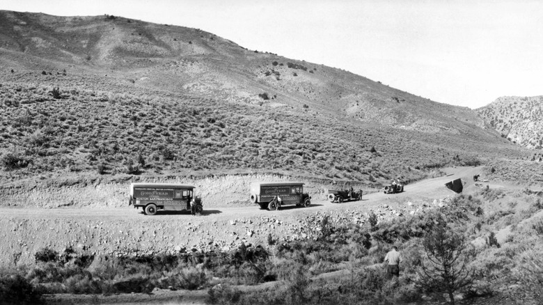
Imagine, if you will, a U.S. landscape not completely saturated in endless routes and interstates. We're talking fields and farms, towns connected by rail, and roads confined mainly to cities. This was what the U.S. looked like following the great rail boom of the late 19th century (roughly from 1870 to 1900, when 170,000 miles of track were laid) and before any kind of comprehensive road system wound across the country. Come 1913, though, automotive industrial leaders and car aficionados formed the Lincoln Highway Association (LHA) with the sole intent of building a cross-continental highway for automobiles. Thus, the Lincoln Highway was born, stretching all the way from New York City to San Francisco.
Spanning 3,000 miles along a jagged line, the Lincoln Highway passed through New York, New Jersey, Pennsylvania, Ohio, Indiana, Illinois, Iowa, Nebraska, Wyoming, Utah, Nevada, and finally, California. The byway takes on special significance in Nebraska as the only road to cross the entirety of the state (about 430 miles), and because both the name of the state capital and the road itself are named after President Abraham Lincoln. Today, you can't drive the original road end-to-end, but you can drive along patches of it like the 6-mile span that runs roughly from Fremont to Ames in Nebraska.
But even if you can't drive along the whole Lincoln Highway, the modern Route 30 more or less shadows the original route. It converges and diverges at certain junctions, and passes by some prominent locations that act as monuments to the original route, particularly along the curve from Grand Island to North Platte, Nebraska. Along this stretch, east to west, the Stuhr Museum, The Archway, and the Buffalo Bill Ranch State Historical Park continue to tell the tale of America's pioneer, the Old West.
Explore pioneer history along the Lincoln Highway
In many ways, the Lincoln Highway was the latest, inevitable, more tech-fueled version of the famed Oregon Trail that 300,000 to 400,000 settlers followed westward from the 1840s to 1860s. Or, it was a reflection of the later Route 66, the legendary highway that wound from Chicago to Los Angeles and which came to symbolize the vast, enterprising, and bold spirit of 1950s America. The Lincoln Highway is easily the lesser-discussed cousin of either route, no matter that it inscribed the U.S. with an image that's come to identify it to this day: the car and the road.
In Nebraska, folks wanting to partake in this lineage can visit the Stuhr Museum located in the south of Grand Island near Route 30, which syncs up with the Lincoln Highway around Columbus and empties into Pine Bluffs, Wyoming. The museum itself sits in the middle of an artificial lake on a grand stretch of lawn and contains many artifacts from the 1800s. More cool than anything else, though, is the museum's period-accurate, walk-through replica called Railroad Town, similar to Old Sturbridge Village in Massachusetts.
Further west from the Stuhr Museum, you'll find The Archway near Kearney. This historical complex is composed of an arched bridge hanging over Interstate 80, along with replicas of historical buildings like the Sod House, and a period-centric museum. This is a great highway stop, as it contains a souvenir shop, trails for stretching your legs, an educational mining activity for kids, and much more. About 90 minutes west of The Archway, you'll find the Buffalo Bill Ranch State Historical Park, a sprawling, outdoor expanse with trails and camping grounds named in honor of 19th-century Old West showman, Buffalo Bill.
Drive from marker to marker along Nebraska's span of the Lincoln Highway
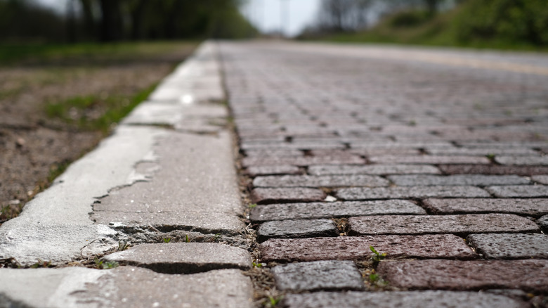
There are plenty of other Lincoln Highway-related sites to see along Nebraska's stretch of the historical road, aside from prominent locations like the Stuhr Museum, The Archway, and the Buffalo Bill Ranch State Historical Park. The entire east-to-west route starts at Omaha next to the border with Iowa and moves, wave-like, through places like Fremont, Columbus, Grand Island, Overton, North Platte, and Sidney. Historical markers crop up along this entire path like scavenger hunt items. Most prominently, this route includes a few sections of beautiful, quaint red brick instead of asphalt, like the 3-mile strip at Elkhorn between North 174th and North 192nd. It's not quite a landscape that highlights Nebraska's natural beauty and incredible history like Fort Robinson State Park in the state's northwest, but if you're game, you can make the detour to Fort Robinson, anyway.
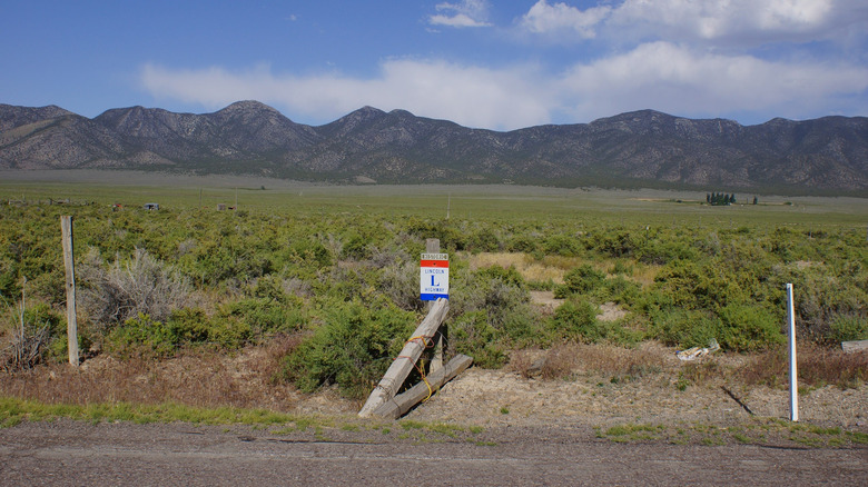
Besides these red brick strips, folks can spot a small Lincoln Statue in Fremont off of North Broad Street, what's called a "seedling mile" (an original tentpole for the Lincoln Highway) at Grand Island, and the short Lincoln Highway Bridge at Overton, complete with an "L" on the side in a red, white, and blue sign. Those signs were placed by the Boy Scouts as part of a 1928 highway-marking venture. A bit after Overton in Gothenburg, you can catch a glimpse of an untended section of the original highway, now just an oddly flat and clear track of green grass. On top of this, folks wanting to commemorate their car-based excursion with a weird side trip can always visit Carhenge in Alliance, Nebraska, a bizarre, to-scale replica of Stonehenge using old cars instead of stones.