Wyoming's Remote 'Road Less Traveled' Is A Rugged, Scenic Backcountry Byway That Comes Alive In The Fall
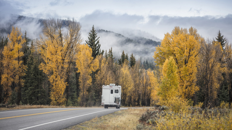
When it comes to fall foliage getaways, New England destinations often take the spotlight, but heading out west grants a different kind of experience, as red sandstone cliffs brilliantly complement the crisp autumn air. It's the perfect season to hit the road on some of the country's most spectacular drives that wind through the West's rugged landscape. If you're looking for a romantic American road trip idea or just want to sample some of the Western United States' best autumn views, the Red Gulch/Alkali Backcountry Byway in Wyoming is a wonderful option off the beaten path. Called the "road less traveled" by the Wyoming Office of Tourism, the route extends 32 miles and can be completed in about a two-hour drive. It passes several exceptional sites that you may want to spend more time at: a Jurassic-era dinosaur tracksite, preserved ancient petroglyphs, and the red cliffs of the Chugwater Formation.
The byway starts in the small town of Shell, Wyoming, north of U.S. Highway 14. You can reach the northern end in about an hour by driving from the Yellowstone Regional Airport, though this location only serves flights from Denver. If you're coming from elsewhere and want to avoid transfers, you can fly into the larger Billings-Logan International Airport, which is about 2.5 hours away. You'll notice how remote the scenic byway feels, which contributes to the untouched, wild views that are perfect to take in under fall's clear skies. Parts of the route even pass directly along the border of the uninhabited Alkali Creek Wilderness Study Area, where cottonwoods turn golden in the season.
Fascinating stops along the Red Gulch/Alkali Backcountry Byway
What makes the Red Gulch/Alkali Backcountry Byway stand out is its unique stops that showcase the surprising history and natural beauty of this secluded slice of the West. Just about 5 miles in is the Red Gulch Dinosaur Tracksite, the largest in the state. Here, dinosaur tracks from 160 to 180 million years ago march across the limestone rockbed. A boardwalk with informational signs winds along the tracks, though you can even step directly on the prehistoric footprints yourself. The site is also popular for finding fossils, and visitors are welcome to take home what they uncover (so long as they're not vertebrate or petrified wood fossils).
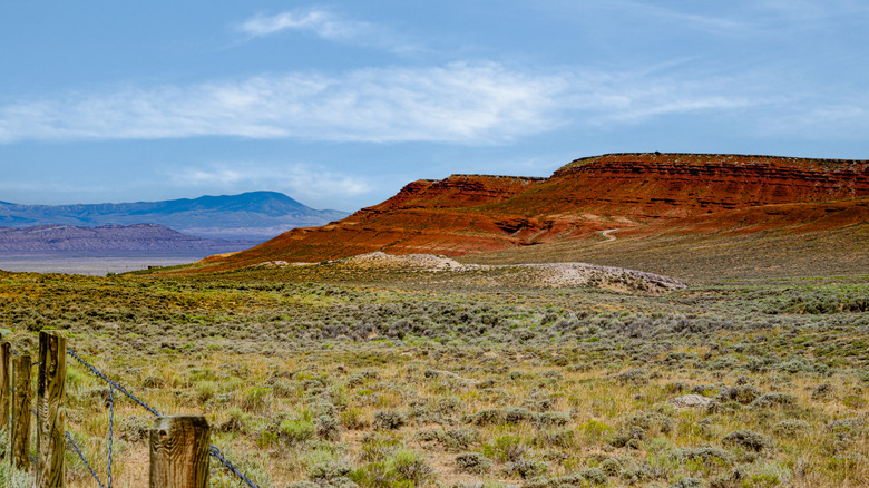
As you continue south, your drive is framed by the jagged ridges of the Bighorn Mountains, in the midst of which are some of the most surreal rock landscapes. All around the route, you'll get views of the canyons, cliffs, and caves that make up the Chugwater formation, known for its deep red, angular rock. Layered, fortress-like cliff formations tower up from badlands dotted with sagebrush, as you pass not only the Alkali Creek WSA, but also the Medicine Lodge Wilderness Study Area. Here, you can spot bighorn sheep on a hike along the Medicine Lodge Canyon or go fishing in its creek.
Off just to the east of the route is an awe-inspiring destination to see ancient rock art: the Medicine Lodge Archaeological Site. It features hundreds of petroglyphs carved by ancient native people covering a 700-foot-long sandstone cliff. It's free to visit and open year-round, though if you come between April to the end of October, you'll get to step inside the park's interpretive museums housed in historic log cabins.