Colorado's Scenic Byway South Of Denver Connects Charming Gold Rush-Era Towns, Mountain Parks, And Canyons
Colorado has some of the most stunning natural beauty in the country. There is a vista around every turn, making the Centennial State perfect for scenic road trips. In fact, there is one itinerary that takes you to all four of Colorado's National Parks. However, for a scenic drive that takes visitors to canyons, mountain parks, and Gold Rush-era towns, spend some time driving the 131-mile Gold Belt Byway. The byway, which can be accessed in Florissant on U.S. Highway 24 (head south) and in Canon City on U.S. Highway 50 (head north), traces the path that stagecoaches and railroads used to follow. The Colorado Springs airport is the closest airport to Florissant (45 miles away), while Pueblo Regional Airport is closest to Canon City (47 miles away). Tourists wanting a larger airport can fly into Denver International Airport and drive 117 miles to Florissant or 136 miles to Canon City to start their journey on the Gold Belt Byway.
You will pass through several small, charming communities (in order: Florissant, Cripple Creek, Victor, Florence, Canon City) with a mining history. Cripple Creek's connection to gold mining dates back to the 1890s, when it was home to the largest and final gold boom in Colorado. Ten casinos are within steps of each other, giving visitors to Cripple Creek a second way to "strike it rich." Historic Victor (nicknamed "The City of Gold Mines") is a mere 5 miles from Cripple Creek and offers visitors gold mining opportunities, plenty of hiking trails, and mining structures from the 1890s. Florence had, at one point, nine mills that processed gold arriving by train from Cripple Creek. Today, visitors can enjoy shopping and dining in the town's 20-block downtown historic area or enjoy a day of fishing or rafting on the Arkansas River.
Mountain parks along the Gold Belt Byway
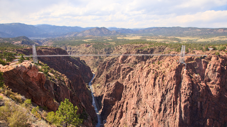
The Gold Belt Byway will take you to some amazing mountain parks, so plan extra time to explore them. Royal Gorge Park (12 miles from Canon City) is home to the highest suspension bridge in the country, a staggering 956 feet above the Arkansas River at the base of the gorge. The bridge, which is made of 1,257 wooden planks and can handle winds up to 125 mph, stretches 1,260 feet and allows visitors to experience spectacular views as they walk from one side of the gorge to the other. While the bridge (and the views it provides) is the star of the park, there are plenty of other attractions to enjoy at Royal Gorge Park, including a zip line, sky coaster, and gondola. The aerial gondola offers 360-degree views of the park, the gorge, the Arkansas River, and the surrounding mountains from 1,200 feet in the air. The ride is included in the admission price, and guests can ride it as often as they want.
Florissant Fossil Beds National Monument (3 miles outside Florissant) offers a glimpse into prehistoric Colorado. The story of yesteryear is told through viewing the thousands of well-preserved fossils of more than 1,700 species, primarily insects and plants. The first stop should be the visitor center to pay the entrance fee, talk to a ranger, and plan your visit. Plenty of hiking opportunities are waiting for you at the monument; you can take a self-guided hike on the Geologic Trail, the Ponderosa Loop, and the Petrified Forest Loop. If you want to keep exploring, there are 14 miles of nature trail on the property. Before leaving, be sure and check out Hornbek Homestead (built in 1878) and the large petrified redwood stumps, some up to 14 feet in width.
Viewing Canyons on the Gold Belt Byway
There are still lots of memories to make as you enjoy the Gold Belt Byway; the road is home to numerous stunning canyons, including the Colorado National Monument (nicknamed the Centennial State's "mini-Grand Canyon"). While not as large as the mini-Grand Canyon, Phantom Canyon is stunning in its own right. Getting to the canyon is half the fun; the road is full of twists and turns, and climbs in elevation from 5,500 feet to 9,500 feet. Phantom Canyon Road traces the route of the Victor and Cripple Creek Railroad and is at the southern end of the Gold Belt. The nature preserve spans 1,120 acres and can only be accessed with a guide from the Nature Conservancy. Visitors get the chance to view this unspoiled preserve by hiking down 500 feet from the rim into the canyon. As you hike along the river, keep your eyes peeled for wildlife sightings, unique geological formations, and more than 200 species of plants.
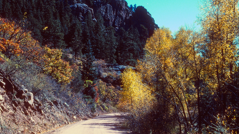
Carved out of the wall of a canyon, Shelf Road is unpaved and considered to be the most rugged drive on the Gold Belt Byway. The road traces the old stagecoach road to Cripple Creek and has an elevation gain of around 4,000 feet. The dirt road is narrow in spots and has some rather steep drop-offs, but if you conquer the drive up, you will be rewarded with some amazing climbing opportunities. In fact, the area is widely considered to be one of the best climbing areas in the state. If you want to stay and spend more time exploring the area, there are two campgrounds on Shelf Road.