Missouri's Scenic Byway Cuts Through The Ozark Mountains To Show Off The Best Of The 'Show Me' State's Beauty
Take the road less traveled with a trip to a scenic road that unveils the hidden treasures of Missouri, the Ozark Run Scenic Byway. The route is the newest official byway of the state, made official in 2023. It spans 78 miles and cuts through the Ozark Mountains, taking you on a trip away from the major highways. You'll pass through small towns, hidden gem attractions, and several counties. It starts near Washington State Park, making your way through Route 21 and 8, and ending in the Black River area.
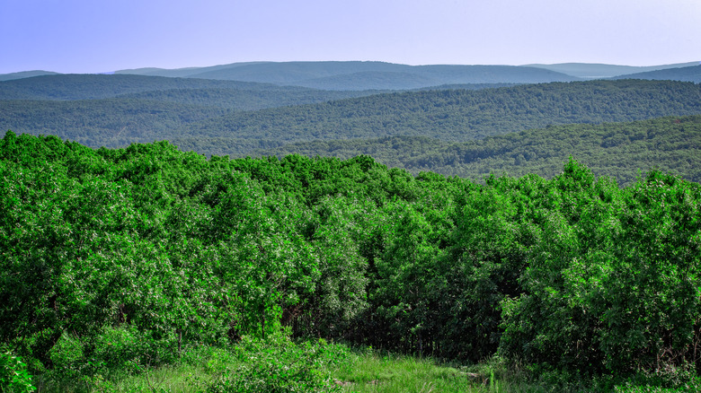
The region of the Ozarks is a bit hard to define, as it's a vast area that's a part of the U.S. Interior Highlands. Many stops are often associated with the area, such as Springfield, a place nicknamed the "Queen City of the Ozarks" that's filled with quirky vibes. But away from the bigger destinations, the rugged terrain, scenic views, and more remote areas of the Ozark Run make this a different kind of road trip. The route of the byway was initiated in 2020 by Eric Hermanson, a St. Louis resident who wanted to find a way through the region, but only through driving on the lesser-known two-lane roads. This route through the scenic area highlights spots often missed, as visitors keep to the more well-known highways.
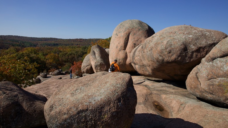
Along the way, discover the historic village of Caledonia or the mountain towns of Pilot Knob, Ironton, and Arcadia. Find yourself amidst 1.5-billion-year-old granites that look like elephants at the aptly named Elephant Rocks State Park. Or take on thrilling outdoor adventures at Mark Twain National Forest.
The different sections of the Ozark Run Scenic Byway
The Ozark Run can be separated into two sections: The Meramec Sprint and the St. Francois Sprint. The former starts at the Big River near Washington State Park, following Route 21. It extends for 35 miles, turning west to Berryman on Route 8. Here, you'll enter the Mark Twain National Forest, a stop that offers trails, crystal-clear springs, biking, and horseback riding. The St. Francois Sprint starts in Potosi back on Route 21 and travels southward to the Iron and Reynolds County line near Lesterville. It's the longer of the two sprints at 43 miles and is dotted with lots of nature recreation areas and three of Missouri's state parks.
If you're up for the adventure, the three state parks are all right near each other, and each has its unique attraction. First, there is Elephant Rocks State Park, where you can take a tour of the elephant-like granites and boulders that make the state park one of a kind. Taum Sauk Mountain State Park is home to the highest point in the state, Taum Sauk Mountain at 1,772 feet, and also houses the state's tallest wet-weather waterfall, Mina Sauk Falls. Further down the route is Johnson's Shut-Ins State Park, a spot known for swimming in the shut-in, a geological wonder that's similar to a gorge. Just be sure to have your water shoes and life jackets with you, as the river conditions can change at any moment.
Reaching the byway and exploring more of its stops
If you're coming from further away, you can fly in from St. Louis Lambert International Airport, about 70 miles away. If you've got the time, St. Louis is also a good first-day stop and is home to one of the only U.S. National Parks entirely within a city. But you'll also see a lot of state parks, forests, and wilderness areas along the byway, with some close to the road and towns and others requiring an extra trip. Make sure to check what sites are best suited for what you're looking for — whether it's more of a hiking trip, floating and splashing on the Black River, or a heritage tour of the small towns you'll pass through. A trip in the fall or even the off-season after summer could be the best time to visit. The byway also features scenic fall foliage landscapes, the perfect background for your road trip.
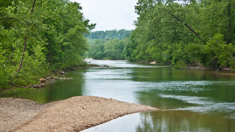
End your trip at the Iron and Reynolds County line near Lesterville, where you can end the road trip casually floating down the Black River. The area is popular for floating trips on canoes, rafts, kayaks, and tubes on the river. Throughout the byway, you'll also encounter the Ozark Trail. This multi-use path covers more than 400 miles of the Ozarks and can be done in small segments and sections. You can find sections of it in the Mark Twain National Forest and the Taum Sauk Mountains. The trail is an ongoing project that could hopefully connect to the Ozark Highlands Trail in Arkansas.