The 'Appalachian Trail Of The Biking World' Is An Iconic 4,200-Mile Long Route With Wild Beauty

Ask any outdoor enthusiast on the planet if you can take a look at their bucket list, and you can bet your mortgage and your life savings that the Appalachian Trail will be popping up a fair few times. Stretching all the way from Maine to Georgia, the legendary hiking route weaves its way across epic American terrain for over 2,197 miles. Officially the world's longest hiking-only footpath, the enormous trail lures adventurous souls like moths to a flame. For people who love nothing more than stomping their boots through isolated stretches of nature and camping out in the wilderness night after night, it's the stuff of dreams. The TransAmerica Trail is the biking world's answer to such a challenge.
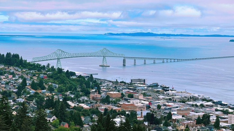
Running for just over 4,200 miles between Astoria, Oregon, and Yorktown, Virginia, the TransAmerica Trail is your chance to pedal all the way from the Pacific to the Atlantic over the course of several energy-sapping weeks. Along the way, you can camp at Yellowstone National Park and see the wildflowers and lakes at Grand Teton National Park. Luckily, the whole route is paved.
Anyone serious about riding the TransAmerica Trail in its entirety should note that it takes roughly three months to complete. Some cyclists, of course, finish the route quicker, but in doing so, they leave themselves less time for sightseeing. And in the case of the TransAmerica Trail, this is a crying shame, as there really are so many things to stop and gaze upon during the ride. Tempted to take this thing on? Before telling your friends and family that you're going away for a while, heading to the garage, unlocking your bike, and hitting the open road, here are some things you should know about one of the most jaw-dropping journeys you can make on a bicycle in the U.S.
The history of the TransAmerica Trail
The TransAmerica Trail's story began in 1973. It was dreamed up by the co-founders of the Adventure Cycling Association, during a ride from Alaska to Argentina, as a way to celebrate the United States of America's 200th birthday. This ambitious idea to ride across the country from one side to the other was finalized with the completion of the trail route in June 1976.
With various maps and guidebooks published to mark the big occasion, all that was needed to cement the route's new status was a bunch of cyclists intrepid (or crazy) enough to give it a go. The cleverly named "Bikecentennial" event saw organizers drum up a whole load of publicity and, thanks largely to some strong word-of-mouth in the pre-internet era, roughly 4,000 cyclists came down to christen the TransAmerica Trail and set out on what would become the biggest bicycle route in the U.S.
Most of the cyclists were young, with no long-distance cycling experience to fall back on. Many of the bikes they rode on were basic to say the least and, with little to no thought given to health and safety, there weren't many helmets between them either. Times have changed regarding equipment, of course — now, you can navigate much of the route with Google Maps, though it helps to have a physical map on you in case you lose cell signal or a map fails to download.
Riding the TransAmerica Trail
Almost as soon as you've set off from the official starting point in Astoria, Oregon, you'll be enjoying the hills of "Little San Francisco." Though you've just begun, make time for the view from atop the Astoria Column. It's a nice reward for some uphill pedalling early on. After that, your first few days on the saddle will take you from the Willamette River Valley and the verdant western side of the Cascade Mountains through to an ancient lava field and some eyebrow-raising dry terrain beyond the McKenzie Pass. In Idaho, it's all about the Little Salmon and Salmon rivers as well as the Middle Fork Clearwater and Lochsa rivers. One cyclist who conquered the route said in the r/bikepacking subreddit that this section was particularly perilous, as hard, spiky seed pods called "goatheads" caused him to get one flat tire after another. Crossing over into Montana, you're sure to be stopped in your tracks by the majesty of its wide valleys and mountain passes.
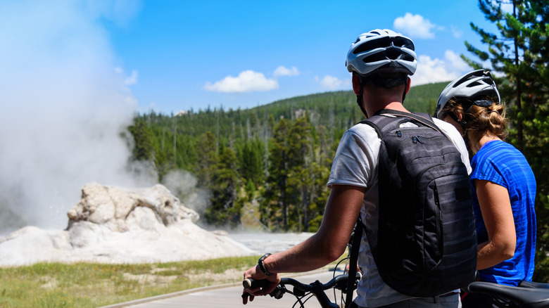
With countless gorgeous views in Yellowstone National Park and of the Grand Teton Range, Wyoming really needs to be savored as much as humanly possible. After the alpine terrain of Colorado and the Continental Divide at Hoosier Pass, you'll eventually leave the Rockies behind. From there, you'll be riding over the Great Plains of Kansas and the undulating landscape of Missouri before crossing the Mississippi River in Illinois. The towns along this route are all accustomed to bicycle traffic, and you'll be able to find plenty of cheap places to stay overnight and affordable spots to fuel up for the next day's journey. Natural points of interest in the latter stages of your journey include the Appalachian Mountains and Mammoth Cave National Park in Kentucky, as well as Blue Ridge Parkway in Virginia. At journey's end, if your legs are up to it, celebrate your mammoth journey with waterfront walks in Yorktown.