The 5 Longest Rivers In America Are Breathtaking Bodies Of Water

The United States has quite a formidable landmass, with thousands of square miles stretched between two oceans, mountains, deserts, great plains, and everything in between. With such a large area, the U.S. also has an extensive network of inland rivers and waterways cutting through its diverse terrain. The cumulative length of America's collective rivers is almost impossible to calculate, but you don't need an advanced degree in hydrology to see that these waterways are quite often epic and beautiful destinations. Such a diverse expanse of river systems also provides the U.S. with a splendid diversity in riverside experiences. Travelers across the country can find everything from dangerous American rivers to avoid to some of the most scenic and charming river towns in the United States. And yet, while even the shortest U.S. rivers are often worthwhile destinations for scenery and recreation, most of the nation's collective attention goes to its longest river systems.
While the United States doesn't have anything quite as long as the world-famous Amazon or Nile Rivers, the longest rivers that flow (at least partly) through its borders are still no slouches when it comes to length. The longest rivers in the United States exceed 2,000 miles, and often pass through multiple states (and sometimes multiple countries) on an epic tour of the North American landscape. The shores of these extraordinary river systems are usually home to amazing cities, cozy small towns, and magnificent views. According to U.S. Geological Survey (USGS) data, the following are the five longest rivers in the United States — and, at times, in Canada and Mexico too. Each river on this list is a breathtaking body of water for reasons other than its sheer length, passing through diverse terrains, top urban destinations, and some of the nation's best riverside parks.
The Arkansas River
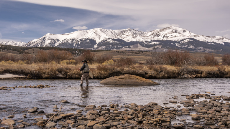
No offense to the great state of Arkansas, but the Arkansas River is so much more epic than its namesake state would suggest. Though the Arkansas River gives its name to a southern state, the river's headwaters actually originate in the monumental Rocky Mountains of Colorado. From its rugged origins in the Colorado Rockies, the Arkansas flows southeast through Kansas and Oklahoma before finally emptying into the Mississippi River in the state to which it lends its name. The river's total length, from the Rockies to the Mississippi, is about 1,469 miles. This is enough to place the mighty Arkansas in the list of the longest rivers in the United States.
Like other long and prominent rivers, the Arkansas River flows through several distinct ecosystems. In addition to the mountainous terrain of its headwaters, the Arkansas also flows through flat prairies, bluffs, and lovely cottonwood forests in Oklahoma and Kansas, before passing through a ravishing network of cypress swamps and wetlands in Arkansas. The Arkansas River's mountainous origins create plenty of spots for river recreation, especially in its Colorado portion. Here, the river drops around 10,000 feet in only 125 miles as it descends from its high-altitude starting point. This section of the river is rich in thrilling water recreation, particularly epic whitewater rafting routes.
This portion of the river is also home to many of its best parks. For example, the roughly 150-mile stretch of the Arkansas between Leadville and Lake Pueblo in Colorado forms the unforgettable Arkansas Headwaters Recreation Area, one of Colorado's (and the country's) top spots for camping, fishing, and river paddling. Further downstream, in Kansas, the Big Bend of the Arkansas River forges a particularly scenic area of the much larger Santa Fe National Historic Trail.
The Rio Grande
Regardless of its length, the Rio Grande is one of the most significant rivers in both the United States and Mexico. If you're familiar with American geography, you probably know that the Rio Grande forms the official border between Texas and Mexico (where it goes by the name "Rio Bravo"). This border was quite controversial back in the 19th century, during the Mexican-American War, which was largely fought over the status of Texas and its border with Mexico. Several battles, conflicts, and treaties later, the Rio Grande is one of the most important rivers in American history.
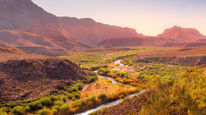
Historical significance aside, the Rio Grande is also a magnificent river system. At around 1,900 miles long, the Rio Grande is the fourth-longest river in the United States. And while the river is best known as the border between Texas and Mexico, it actually extends northward through New Mexico and Colorado. Like the Arkansas River, the Rio Grande actually originates in the Colorado Rockies and flows southeast to the Gulf of Mexico.
With real estate in Colorado, New Mexico, and Texas, the Rio Grande also flows through some of America's most breathtaking Southwestern scenery. The Rio's epic beauty hits its crescendo at Texas' magnificent Big Bend National Park, where the "big bend" of the Rio Grande cuts through a spectacular network of canyons, mountains, and picturesque desert landscapes. Nearby, Texas' equally amazing Big Bend Ranch State Park offers additional Rio Grande views in a more low-key state park setting. An additional 196 miles of Texas' Rio Grande comprises the Rio Grande Wild & Scenic River. Beyond Texas, the Rio Grande is also featured in Colorado's divine Rio Grande National Forest and New Mexico's Rio Grande del Norte National Monument.
The Yukon River
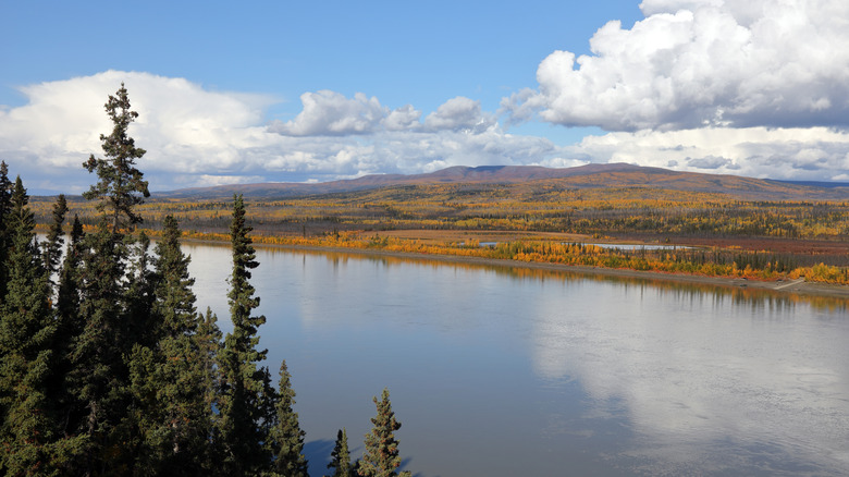
Of all the major rivers of the United States, the Yukon River may be the most remote. While the Yukon Territory, with which the river shares its name, is in Canada, much of the river's course flows through the wild northern landscape of Alaska. The Yukon's 1,980-mile length actually begins in northern British Columbia, where it flows into its namesake Yukon, through vast expanses of Alaskan terrain, before finally emptying into the Bering Sea. While this far northerly location means that the Yukon is much "wilder" than other prominent American rivers, the Yukon River Watershed is actually a significant source of water, fishing, and industry for those living in the area, particularly several indigenous communities in Canada and Alaska.
Still, the mighty Yukon does have some of the most rugged river paddling adventures in either country. In Canada, the Yukon offers several unique river routes, with embarking points in both British Columbia and the Yukon Territory. As remote as this area is, you can find plenty of excellent outfitters who offer canoe or kayak rentals for trips along the Yukon, or even a paddling tour with an experienced guide. Many Canadian sections of the river pass through some of the country's national parks, like the S.S. Klondike National Historic Site.
In Alaska, the Yukon River is a major component of the vast and pristine Yukon-Charley Rivers National Preserve. Here, experienced paddlers and outdoorsy types can challenge themselves with the 158-mile Eagle to Circle route along the Yukon River. The Yukon-Charley Rivers National Preserve also offers several scenic hiking trails and historic sites, all with incredible views of the Yukon River itself. Elsewhere in Alaska, die-hard paddlers can find plenty of other Yukon River access points from the Alaska-Yukon border to the Bering Sea.
The Mississippi River

Given its prestigious spot in America's popular imagination, many people would be surprised to learn that the iconic Mississippi River is only the second-longest river in the United States. However, the Mississippi's 2,340-mile course is still an impressive aspect of America's landscape. From its origins in Minnesota's lakes to its final terminus in Louisiana's Gulf Coast, the Mississippi serves as a foundation of America's geography — as well as America's culture. The Mississippi's unsurpassed impact on American culture can be seen everywhere from the works of Mark Twain to the foundational Mississippi Delta Blues. The river's impact on American history and culture is so impressive that the river's actual length is somewhat overshadowed.
Of course, there's no denying its length is formidable. The Mississippi begins at the deceptively modest headwaters of Minnesota's Lake Itasca, and from there flows south through Wisconsin, Iowa, Illinois, Missouri, Kentucky, Arkansas, Tennessee, Mississippi, and Louisiana. The river's entire drainage basin is the largest in North America, measuring a whopping 1,260,000 square miles. During this course, the river's banks serve as home to many of the nation's most vibrant cities, including the twin cities of Minneapolis and St. Paul in Minnesota, the one-of-a-kind city of New Orleans, and acclaimed cities like St. Louis, Memphis, and Natchez in between.
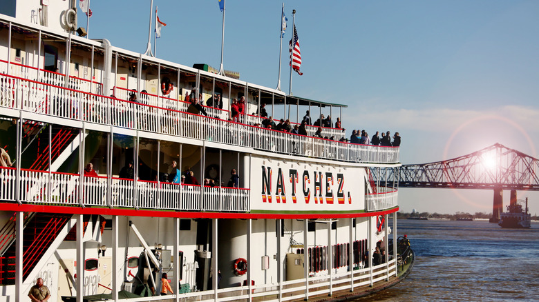
The Mississippi River's banks are also home to numerous parks and public lands, including St. Louis' famous Gateway Arch National Park and Lacede's Landing Riverfront District. Today, the Mississippi offers plenty of terrific recreation, particularly famed New Orleans riverboats like the steamboat Natchez. Unfortunately, the majestic Mississippi River is also one of America's most endangered waterways, due to a combination of artificial dams, pollution, and climate change. This just goes to show that even mighty rivers like the Mississippi require protection.
The Missouri River
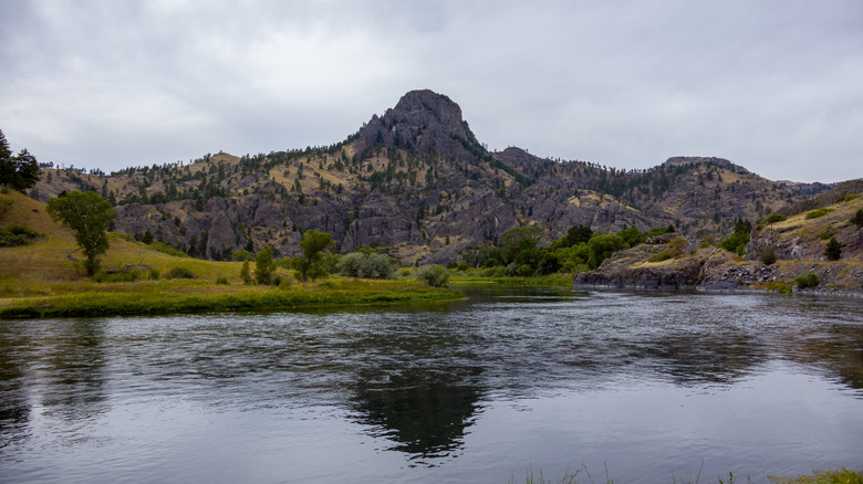
The epic Missouri River is technically a tributary of the much more famous Mississippi River. However, through an odd geographical quirk, the Missouri is actually about 200 miles longer, clocking in at an estimated 2,540 miles. This extra 200 miles earns the Missouri River the title of "longest river in the United States." Yet this superlative does not adequately capture the Missouri's extraordinary nature. Unlike the Mississippi River's somewhat humble origins in a small Minnesota Lake, the Missouri River roars to life in the rugged Bitterroot Mountains of southwestern Montana, where the eastern slopes of the Rocky Mountains tower over the nearby Continental Divide. From there, the Missouri passes through dramatic landscapes in America's Mountain West and Great Plains, with stops in Montana, North Dakota, South Dakota, Nebraska, Iowa, Kansas, and finally its namesake state of Missouri. Here, the Missouri River finally ends its 2,540-mile course at St. Louis, where it joins the Mississippi in its southward flow to the Gulf of Mexico.
The Missouri River's importance for transportation, infrastructure, and industry resulted in numerous cities along its banks. In addition to St. Louis, the Missouri's shores are home to places like Kansas City, Omaha, Bismarck, and Montana's gorgeous city of Great Falls. The Missouri's often rugged landscape is perfect for unforgettable national and state parks. Montana's share of the river is particularly notable for its amazing parks, including treasures like the Upper Missouri River Breaks National Monument, Tower Rock State Park, and the Upper Missouri National Wild and Scenic River. Downstream of Montana, you can find equally amazing Missouri River parks like South Dakota and Nebraska's Missouri National Recreational River, Missouri's Annie and Abel Van Meter State Park, and much of the multi-state Lewis & Clark National Historic Trail.
Methodology
At first glance, compiling a list of America's longest rivers seems like a fairly easy task. All you would need is each river's total length in miles, and then rank them based on which numbers are bigger. However, getting accurate data on the exact length of America's rivers is a bit trickier than you may expect. This is due to a phenomenon called the coastline paradox. Essentially, coastlines are notoriously difficult to measure objectively, since they don't form straight lines. The closer you look at a coastline, the more divergent features (like bays, inlets, peninsulas, etc.) you'll find. This means that the exact measurement of a coastline can vary wildly depending on who's doing the measuring.
The same paradox also applies to rivers. As a result, you can find different "official" lengths of America's longest rivers from different sources. Since many of America's longest rivers have similar lengths, a variation in length measurements can alter the ranking. For example, some rankings have the Colorado River, not the Arkansas River, as the fifth-longest river in the United States.
To get around this conundrum, we based our list of the longest American rivers on official data from the U.S. Geological Survey. Returning to the issue of the Colorado and Arkansas Rivers, the USGS lists the Arkansas at 1,469 miles and the Colorado at 1,450 miles. So the former barely edges out the latter on our list. We also needed to hone in on specific criteria for what constitutes a "river." Some sources list the 1,900-mile St. Lawrence Seaway within the top five longest rivers in the U.S. However, the St. Lawrence Seaway is actually a combination of natural rivers, artificial locks and canals, gulfs, and estuaries. Because of this, we did not include it on our list.