Texas' Underrated Salt Lake Is A Hidden Gem With Trails That Give The Illusion Of Walking On Water

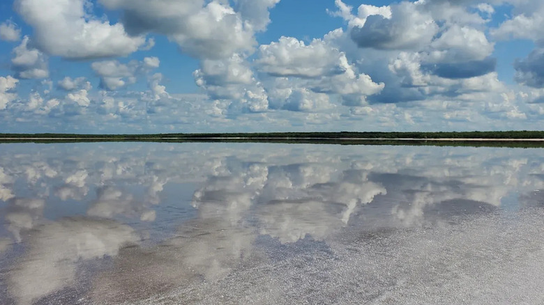
Though the Great Salt Lake of Utah, which is pink around its southwestern island, is America's largest and most well-known salt lake, Texas has its own natural salt lakes that are quite spectacular. There are two in the South Texas Salt Lakes site, though it's La Sal del Rey that's the more accessible, with visually striking scenes of shimmering salt flats along the shores. The lake is spread across a shallow basin with a crust of white salt crystals glittering at its edges and a hill on one side. Two trails lead to the lake and along its shores, and the reflective surface of water on the densely packed salt gives the impression of walking on liquid. That's one of the reasons La Sal del Rey was named one of Texas's 2026 bucket-list destinations by Texas Highways.
La Sal del Rey measures about 530 acres, though its size fluctuates depending on rain and water loss. The shallower it gets, as water evaporates in the Texas heat, the higher the lake's salinity is. At times, it can get up to 10 times saltier than the ocean, according to the University of Texas Rio Grande Valley (UTRGV). The source of this salt concentration isn't totally clear — some speculate that the lake sits on a salt dome, while others, including the UTRGV, say it's more likely because the area's groundwater is naturally salty, and the lake's basin is deep enough that it fills with it. In any case, the salt concentration lends itself to some truly unique visuals. At low water levels, the lake develops a crystalline salt crust, which cracks and forms nearly one-foot-high ridges of protruding crystals. In late summer, the lake can even turn red because of the presence of salt-dwelling bacteria.
Walk the salt flats of La Sal del Rey
La Sal del Rey is located close to Texas's southern border in the Lower Rio Grande Valley, about a 40-minute drive north of McAllen, a foodie destination with America's lowest cost of living. The city's McAllen International Airport is a convenient commercial option for those flying in, with arrivals from several cities around the Southwest. La Sal del Rey is publicly accessible, being part of the Lower Rio Grande Valley National Wildlife Refuge, which grants visitors free entry year-round (though the Western Hemisphere Shorebird Reserve Network notes that access is sometimes limited during birds' breeding season).
Both entryways to the lake require some hiking. The first option is to park off Highway 186, then follow a path for just over a mile one way. There's a historic marker at this parking lot with some context about how the local salt was quarried and valued. The other trail begins at a parking lot off of Brushline Road and is about 0.7 miles one way. Along this trail, there is an observation deck and restrooms.
What you'll see when you reach the lake depends somewhat on the season. If the water is high and the lake fuller, it's possible to swim in it. As it dries later in the summer, the shallow, glassy water thinly spread over the salt flats gives it the mesmerizing mirror appearance. Sometimes the salt is compact enough that "you can almost walk to the middle," as one Reddit user said. "[Its] thick packed salt layer so you won't sink. Barely made a dent picking it with [a] knife." If you want to see more nature of the Lower Rio Grande Valley afterwards, drive north to the Brooks County Safety Rest Area for its renowned birdwatching.