This High-Elevation Trail In Utah Is A Rigorous But Rewarding Hike With Gorgeous Mountain Scenery And Wildlife
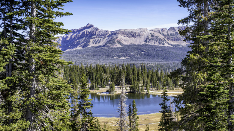
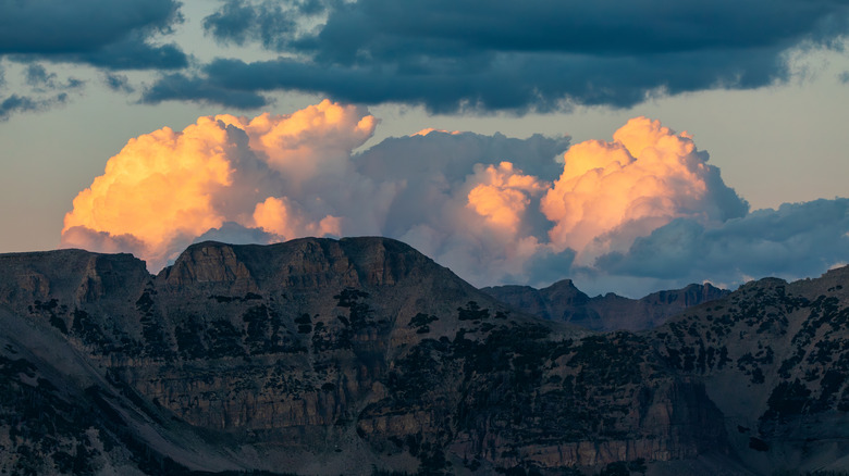
The Uinta Highline Trail (UHT) — pronounced "you-IN-tuh" – is a roughly 100-mile trek through dramatic terrain in Utah's high country. The trail is steep and rugged: You'll gain over 18,000 feet of altitude climbing eight mountain passes, with sometimes brutal descents. But those climbs are rewarded with staggeringly beautiful vistas. You'll see glowing gold mountainsides at sunset, kaleidoscopic meadows of wildflowers, and turquoise alpine lakes set like jewels into red rock basins. "The Uinta Highline put me in jaw-dropping awe more times than I can count," blogger Erik Barrus, who spent seven days on the trail, wrote on Timber & Fins.
The Uinta Highlands are Utah's highest mountain range, full of beautiful lakes and dinosaur fossils. On a week-long trek, you're almost guaranteed to see an abundance of wildlife. Depending on your luck, you may encounter mule deer, otters, big horn sheep, coyotes, and black bears, as well as elk, and moose. Just keep a safe distance. Wolverine and Lynx are around, too, although you're less likely to see these shy predators.
The trail is typically undertaken as a seven-day backpacking adventure, which has you averaging 12 miles per day, although it can be done in as little as four or as many as ten. If you're an experienced backpacker coming from sea level and are used to banging out double-digit trail miles, 12 miles per day may sound like a slack pace, but with the majority of this trail being above 10,000 feet, the lack of oxygen at altitude will sap your energy, no matter how fit you are. Challenging terrain will also slow you down: When you aren't climbing or descending, you'll be picking your way through boulder fields, or navigating wide-open, windswept tundras.
The beauty and challenges of Utah's Uinta Highline Trail
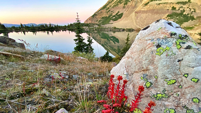
Utah's Uinta Highline Trail requires navigation skills. Sometimes you'll be following a well-marked trail, but once you hit the tundra, the trail will disappear, and you'll be hiking from one cairn to another (cairns are piles of rocks that serve as signposts to aid in wayfinding). Clouds may roil the sky, providing dramatic vistas but also thunder, rain, and hail. The hiking season is short here — just a few weeks in summer — but it has been known to snow even in August.
With great beauty comes equally great rigor and even danger. "The UHT is one of the most amazing trails I've ever hiked," one AllTrails user wrote in 2025. "Dead Horse Pass is also the most dangerous pass I've ever attempted. There was a literal dead horse on the trail ..." Another backpacker posted on Facebook about witnessing a pack mule fall to its death on the pass (mules and horses are a frequent sight on the trail). If the danger gives you pause, by all means heed your instincts and choose a shorter section hike of the trail, which you could complete as an out-and-back, avoiding the need for a shuttle.
Uintahighlinetrail.com is a site maintained by trail enthusiasts that includes detailed descriptions of each section, along with insider tidbits that will enrich your experience of the trail, like the tip to look for elk and moose in the meadows near dawn and dusk. For a visual preview of the trail's scenery and challenges, stream the 2020 documentary feature, "Highline." It's a meditation on hiking as a healing ritual, and will leave you wanting to take on this trail as a life-changing challenge.
The logistics of the Uinta Highline Trail
The Uinta Highline Trail's eastern trailhead is around 200 miles from Salt Lake City International Airport (SLC). While the trail cuts 100 miles through the wilderness, the distance between the two trailheads is 160 miles by road, so you will need to bring two cars, or better yet, use a shuttle service. MTXUtah has everything from scheduled runs between trailheads to private group rides. They'll even pick you up at SLC and take you food shopping if you like.
Some hikers shorten the route by starting or ending at different points. If you don't have 7 to 10 days to spare, consider doing a section hike. AllTrails handily breaks the trail down into sections, and the highest-rated are the 10.2-mile hike between Kidney Lakes and Anderson Pass, and the 13.9 miles between Oweep Creek and Ledge Lake. You have a lot of latitude in your planning as no permits are needed for this hike. The entire trail has multiple alternate routes, as well as bail out points where you can hike out to civilization if you need to. One more thing to consider when planning your hike is that there are no good resupply options other than one dirt road at Chepeta Dam, so the more days you spend on the trail, the more food you'll have to carry.
At the Uinta Highline's 10,000-foot-plus elevations, there is always a risk of altitude sickness. The best prevention is to budget at least one non-hiking day at altitude to acclimate before you set out. You could easily spend a day touring the kooky, charming town of Vernal, aka Utah's "Dinosaurland" and a gateway to prime outdoor thrills, near the Uinta Highline's eastern trailhead. Near the western end is the cute wild west town of Kamas, which is Utah's "Gateway to the Uinta Mountains" with trails, lush parks, and a dazzling lake nearby.