Some Of Colorado's Most Stunning Scenery Is On This Rugged Mountain Trail To An Ice-Blue Alpine Lake
While one cannot name a definitive "most beautiful state" in the U.S., Colorado has a strong claim to the title. Boasting many of North America's gorgeous Rocky Mountain highlights, Colorado is a veritable outdoor wonderland of towering mountain peaks, pristine forests, and superb park sites. Popular destinations like the majestic Rocky Mountain National Park and the impressive Eldorado Canyon State Park and its scenic canyon hikes are among the state's best-known attractions. Then there's one of Colorado's most spectacular hiking routes tucked away in an often overlooked national forest in the southwest corner of the state. Though not as well-known as Rocky Mountain National Park's Emerald Lake Trail or the famed Maroon Bells near Aspen, Colorado's Ice Lake Trail offers some of the most stunning mountain scenery in the entire country.
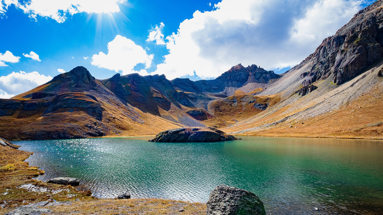
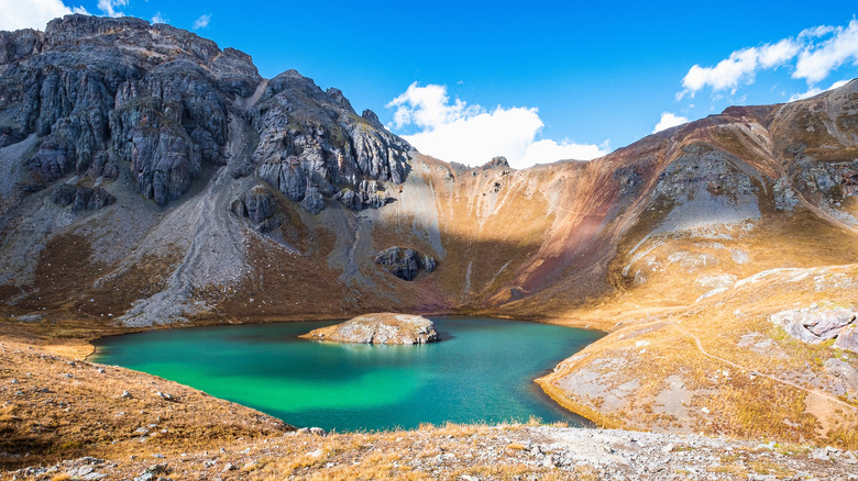
Being a remote mountain route, the Ice Lake Trail is a more rugged hike than more accessible destinations in popular parks. But the trail's scenery is more than worth the challenges you'll face along the way. The trail's elevation gain provides a picturesque tour of the complex ecosystems that populate different altitudes, with some additional features like waterfalls, wildflower meadows, and mountain peaks thrown in for good measure. However, the trail's highlight is arguably its namesake lakes. Though not the largest or most accessible lake in Colorado, the Ice Lakes and their picture-perfect turquoise waters may very well be the most beautiful.
Experience some of Colorado's most enchanting views
Colorado's vast, epic mountain landscape allows for numerous off-the-beaten-path hikes right next to popular outdoor attractions. For example, Zapata Falls is a secret waterfall right next to Great Sand Dunes National Park! Despite its popularity among backpackers and hikers, the Ice Lakes Trail is still a great example of a scenic route that flies under the radar compared to iconic Colorado sights. The trail cuts through the state's dramatic San Juan National Forest, within the rugged San Juan Mountains subrange of the southwestern Colorado's Rockies. The mineral-rich San Juan Mountains were once the site of excessive mining in the 19th and 20th centuries. But fortunately for hikers today, the range's enchanting Ice Lakes Trail remains an unsullied stretch of magical mountain wilderness.
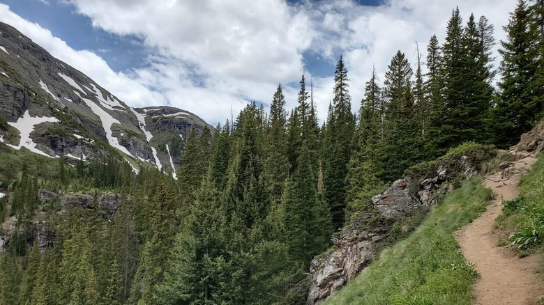
The Ice Lakes Trail extends several miles through the San Juan National Forest's Ice Lakes Basin. Here, the diversity of the eco-regions resulting from elevation changes is on full display. At lower altitudes, the trail passes through beautiful forests of aspen and conifer trees. During the first half-mile, you'll also pass by a lovely mountain waterfall. However, as you ascend above the tree line, the serene mountain forests give way to striking alpine landscapes with once-in-a-lifetime views of the surrounding mountain peaks.
The trail's lower and upper ice lake basins are separated by a 400-foot granite wall. Despite their deceptive proximity to each other, the elevation difference creates two distinct ecosystems. The lower ice lake basin is famed for its incredible wildflower meadows (among the best in Colorado), while the upper basin features sparse alpine tundra and magnificent views of the surrounding mountain peaks. And of course, there's the gem-like ice lakes themselves, famed for their fabulous aqua-marine colors juxtaposed against the surrounding mountain wilderness!
Hike through some of the most scenic spots in the Colorado Rockies
Given the elevation gain and rugged mountain terrain, the Ice Lake Hike is not the easiest in the world. However, it's more manageable compared to technical summit routes like the breathtaking adventure to the top of Colorado's highest summit of Mount Elbert, and other much more daunting Colorado "14er" peaks. Despite its relatively short length of "only" 8 miles round-trip, the Ice Lakes Trail features about 2,420 feet of total elevation gain. Beginning from a starting elevation of around 9,840 feet, you'll ascend above 12,000 feet to Lower and Upper Ice Lake, Island Lake, and finally Fuller Lake (with an ultimate elevation of 12,605 feet).
Despite the steep climbs at points, the trail is generally well-marked and well-maintained, with little to no arduous rock scrambles or highly technical sections. Of course, altitude sickness could be an issue, so it's recommended that all hikers properly acclimate themselves to the higher elevation for a day or two beforehand. While on the trail, always watch out for the early warning signs of altitude sickness (such as dizziness, fatigue, headache, and nausea) and turn back if you start feeling unwell.
The trail conveniently begins at the South Mineral Campground of the San Juan National Forest, so you have a great place to camp overnight if you want to spend multiple days in the mountains. Alternatively, the historic Colorado mining town of Silverton is close by, offering plenty of charming hotels, cottages, and B&Bs amid an authentic Old West character. The nearest international airport is the Albuquerque International Sunport, about five hours away. The Durango-La Plata County Airport is only an hour and a half away, though there are only a few select regional routes there.