Arizona's Canyon Monument Is A Technicolor Wonderland Of Towering Cliffs And Swirling Stone Waves

One of the most iconic images from Arizona is that of the rippling red swirls of sandstone that make up The Wave, a bucket-list hike that has become nearly impossible to do. The Wave is a part of the Coyote Buttes North region of the larger Vermilion Cliffs National Monument. While it can be remarkably difficult to get tickets to see The Wave, the national monument is still worth a visit, as there are plenty of other places where you can see stunningly colorful stone canyons and cliffs formed over millions of years. If you're someone who loves solitude and the rugged beauty of the American Southwest, you'd be hard pressed to find somewhere more incredible than this.
Tucked into the northwest edge of Arizona and into Utah, the Vermilion Cliffs National Monument is between the Kaibab National Forest and the Glen Canyon National Recreation Area. It's a remote part of the country; if you're flying in, it's about four hours from Nevada's Harry Reid International Airport, just one of many national parks and public lands within driving distance of Las Vegas.
Long before it became a national monument in 2000, the land was used by both Ancestral Puebloans and Southern Paiute. The land was also explored by the Spanish in the late 1700s and Mormon pioneers in the 1800s. As for why it was federally protected, the proclamation states, "Amid the sandstone slickrock, brilliant cliffs, and rolling sandy plateaus of the Vermilion Cliffs National Monument lie outstanding objects of scientific and historic interest ... Full of natural splendor and a sense of solitude, this area remains remote and unspoiled, qualities that are essential to the protection of the scientific and historic objects it contains."
Hiking and backpacking at the Vermilion Cliffs National Monument
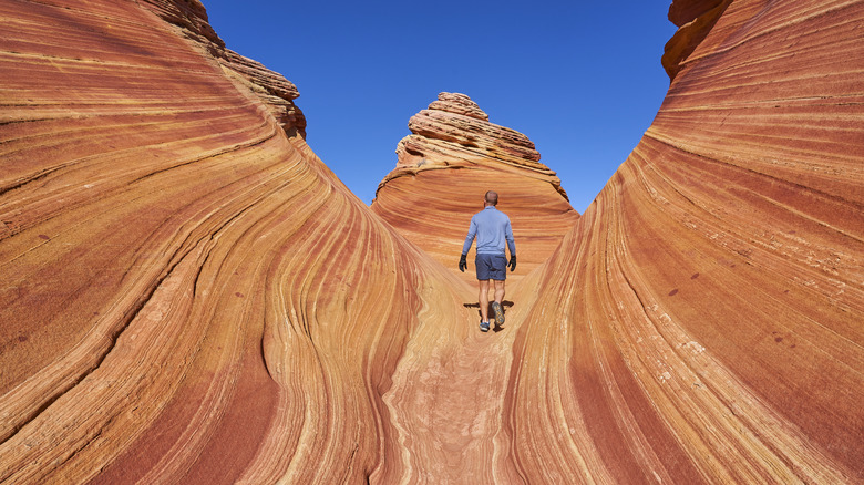
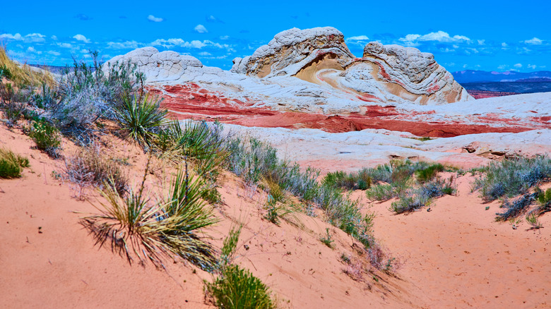
Vermilion Cliffs National Monument is divided into regions, with the Coyote Buttes to the north containing some of the most popular attractions at the monument, including The Wave. If you are hoping to see this surreal and much-photographed landscape with your own eyes, you first have to get a permit. There's a daily lottery for 16 spots that opens 48 hours before the permit day and is only accessible to people who are in the area. You can also try your luck with the Advanced Lottery; it has 48 spots and opens four months before the permit day. Once you get your permit, it's a little over a 6-mile round-trip hike to the undulating and unexpected sandstone features.
To see evidence of some of the people who lived in the area, visit the Maze Rock Art Site. It's about a 1.4-mile hike, and you'll pass by rocks with an impressive collection of petroglyphs. There is also rock art at Buckskin Gulch, one of the longest slot canyons on the planet. It's 16 miles of beautiful twisting and turning sandstone, great for day hiking. For more backpacking, Paria Canyon is another popular spot. It's a total of 38 miles along (and sometimes in) the Paria River. You can also day hike here.
All kinds of wildlife make their home in the area, including endangered California condors. You have a good chance of seeing them at the Condor Viewing Site along House Rock Valley Road. Make sure to bring your binoculars.
Things to keep in mind at Vermilion Cliffs, where to stay, and where to go next
Many of the popular sites at Vermilion Cliffs National Monument require individual day-use permits. There are also regions of the national monument that require a 4x4 vehicle. The temperatures can get upwards of 100 degrees Fahrenheit during the summer, so make sure to bring plenty of water. That being said, flash floods can happen in the area, with water accumulating quickly in the narrow canyons. Stay alert, check the area's weather, and have a plan if you encounter signs of an incoming flood; do not hike Buckskin Gulch if there could be rain anywhere within the surrounding 100 miles. If it's rained recently, wet roads can be dangerously slick, and there's also no consistent cell service throughout the monument. And as always, when you're out exploring nature, remember to leave no trace.
There are two campgrounds at the national monument, along with backcountry camping options. If you aren't interested in camping, consider a stay at the Marble Canyon Lodge, a remote desert lodge less than 30 minutes from the Vermilion Cliffs. As well as giving easy access to the national monument, the lodge is less than 10 minutes from the Lonely Dell Ranch Historic Site with gorgeous orchard and Colorado River views.
Vermilion Cliffs is about 40 minutes from Lees Ferry, a popular launch point for trips on the Colorado River and into the Grand Canyon, and it's about an hour to the North Rim. For those on an American southwest road trip and wanting to see more impressive red rock cliffs and canyons, the Grand Staircase-Escalante National Monument in Utah is about 65 miles away.