This Breathtaking Trail Through The Katahdin Mountains Leads To Maine's Tallest Waterfall
Maine is the getaway destination for travelers chasing true Northeast wilderness. While other New England states like New Hampshire, Vermont, and Massachusetts certainly have amazing natural spectacles to share, Maine is arguably the most rugged state in the region. Its pristine natural splendor is famously encapsulated in the well-known Acadia National Park. With popular Acadia spots like the Thunder Hole inlet, Cadillac Mountain, and Jordan Pond, Maine's lone national park is consistently one of the top draws in the entire U.S. National Park System. Still, Maine is much, much more than Acadia. Further north, the state's epic North Woods region protects vast forests and enchanting hikes that rival Acadia in every way. For many travelers, Maine's best hike outside of Acadia is the stunning, mountainous trek to the enchanting Katahdin Falls, the highest waterfall in the state.
Taken alone, a waterfall as tall and scenic as Katahdin Falls would be enough to make its attached hike one of the state's best. However, the path to Katahdin Falls showcases even more than a single spectacular waterfall. The full hike from the trailhead to the waterfall is a photo-worthy tour of a state park that matches or even exceeds many national parks in terms of monumental scenery. And not only does the Katahdin Falls hike showcase Maine's highest waterfall, it also provides exceptional views (and, depending on how far you go, summit access) to the state's highest mountain! The trailhead to Katahdin Falls is about two hours from Bangor International Airport, and three to four hours from Portland International Jetport. But with such amazing vistas, the longer drive is definitely worth it.
Discover Maine's highest waterfall in Baxter State Park
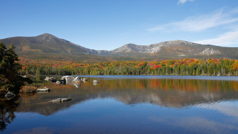
Katahdin Falls is just one of the many remarkable features of Maine's Baxter State Park. Not only does its 209,644 acres qualify it as Maine's largest state park, but Baxter State Park's epic landscape and trails make it a less-crowded alternative to Acadia. Baxter State Park's wild character comes from its location in the North Maine Woods, a vast expanse of untouched forests in the state's northern region that's about as remote as you can get in New England. The centerpiece of Baxter State Park is the 5,269-foot Mount Katahdin, the highest peak in Maine and a prominent icon of the northern Appalachian Mountains. Lying under the mountain's shadow, Katahdin Falls is a fabulous hidden gem well worth a hike through the captivating woodlands encircling Katahdin's mighty peaks.
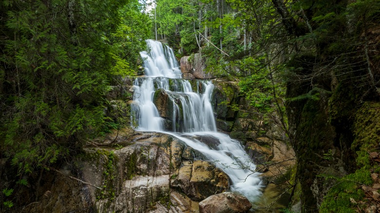
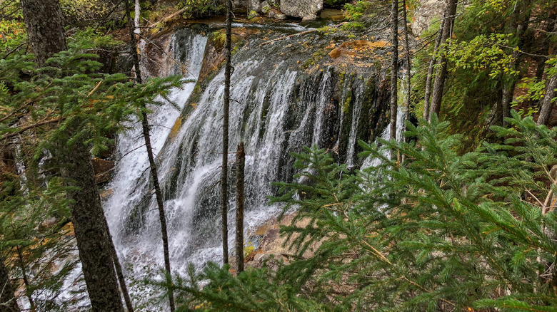
Katahdin Falls reaches a total height of around 800 feet, with about 280 of those feet making up the waterfall's main vertical drop. While this height is certainly impressive, Katahdin Falls is also one of the state's most visually stunning cascades. It consists of several distinct rocky layers, with white water pouring down each like a giant wedding cake. The entire waterfall sits nestled in an exquisite river gorge bracketed on both sides by a rich green forest. Both falls and gorge are part of Baxter State Park's Katahdin Stream, which runs parallel to much of the hike. Alongside its excellent stream views, the trail to Katahdin Falls also showcases Baxter State Park's brilliant wildflowers, with abundant birds making their homes in the surrounding forests.
Explore Maine's breathtaking wilderness on a manageable trail
The main route to get to Katahdin Falls is a 2.6-mile segment of Baxter State Park's epic Hunt Trail. Though you can easily make the relatively short hike to Katahdin Falls in about 90 minutes, the Hunt Trail actually extends all the way up to the top of Mount Katahdin's Baxter Peak. If you're looking for a more under-the-radar mountain view, the Hunt Trail also diverges from the Baxter Peak route for a picturesque detour to the summit of the neighboring 3,695-foot Owl Mountain. Being right next to Mount Katahdin, the Owl offers arguably the best views of its neighboring peak.
If you just want to visit Katahdin Falls, you're looking at a moderately difficult hike through a beautiful forest setting. The first mile or so of the trail is relatively flat, though it does pick up some steepness as it approaches the rocky ledges near the falls. Much of the trail's terrain is unpaved forest floor, though there is a convenient wooden bridge to help you cross Katahdin Stream. Once you get to Katahdin Falls, you might even find natural swimming holes where you can take a dip and cool off.
The Hunt Trail route to Katahdin Falls begins from the parking area at Baxter State Park's Katahdin Stream Campground. This means you have access to a top camping site if you're planning on staying the night in the park. Baxter State Park is also right next to the Katahdin Woods and Waters National Monument, which has its own amazing campgrounds administered by the National Park Service. The nearest town is Maine's charming four-season playground of Millinocket, a hidden small-town treasure with plenty of additional accommodations that let you explore Katahdin Falls with a bit more comfort.