Texas' Scenic Oasis At The End Of A Tough Hike Is A Destination Locals Would Prefer Be Kept Secret
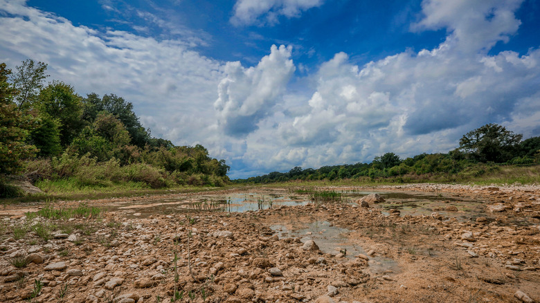
When thinking of dangerous hiking expeditions, the popular Mist Trail in Yosemite National Park or the scenic Huckleberry Lookout Trail in Glacier National Park come to mind as the most dangerous in America. While not known to be life-threateningly dangerous, the hike along the Blanco River to the gorgeous Narrows in Texas poses risks for several different reasons. The Narrows are part of a quarter-mile section of the Blanco River with limestone ledges and 20 to 50-foot-deep black pools. The only way to access this Texas wonder is by traversing a strenuous riverbed for 14 miles in the Texas heat. Unfortunately, what makes reaching this scenic area such a daunting task is that it is surrounded by private land, and the locals prefer to keep the area to themselves.
The Blanco River's trailhead to the Narrows is located about an hour southwest of Austin. It is situated in the middle of a trio of towns: Henly, Blanco, and Fischer. There is an Airbnb two miles away from the upstream trailhead, so it may be worth reserving a room within walking distance prior to making the journey. Finding a safe place to park near the riverbed trailheads is especially tricky since there have been many reports of disdainful locals slashing tires and cutting valve stems on hikers' cars. Because the trail to the Narrows is surrounded by private land, it is very easy to accidentally trespass and anger local residents. To avoid the issue of coming back to a vandalized car entirely, consider getting a rideshare to the trailhead locations. Keep an eye out for purple paint on signs, fence posts, and rocks, as these indicate private property boundaries. Stay on the riverbed the whole time, because only the riverbed is classified as public land owned by the state.
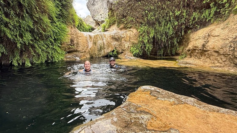
The secluded Narrows along the Blanco River are a worthy reward after a grueling hike
There are two ways that daring hikers can approach the Narrows. The upstream section starts from the low-water bridge on Chimney Valley Road. The downstream section starts closer to Blanco near the intersection between Chimney Valley Road and Route 165. While the 14-mile route upstream is longer than the downstream option, the upstream path usually has less flooding. Hikers who take the downstream route will need a rope for the journey back from the Narrows because of a steep section in the riverbed. The trek to the Narrows takes around five hours to complete, and that is not including the trip back. A round trip with time to stop and enjoy the Narrows often takes 10 to 14 hours, so all hikers should take plenty of water and electrolyte packets to fend off dehydration. Additionally, hikers should bring walking sticks, plenty of snacks, sunscreen, hats for the sun, and hiking boots in preparation for the lengthy and challenging hike.
Hikers will know they are near their destination when they see the limestone gorge carved out by the river covered in green maidenhair ferns. In the gorge, hikers will find the Narrows surrounded by cliff walls that reach up to 40 feet in height. The Narrows are the centerpiece with crystal pools with seemingly no bottom. Because the pools are so deep, they appear dark green or black. These otherworldly pools with smooth edges are called potholes and are perfect for soaking after the long, strenuous hike. It is also a great location for a picnic with views that rival the clear waters of the prettiest lake in all of Texas. Make sure to save some strength for the journey back, since it can be just as grueling.