California's 'Old Grayback' Mountain Wilderness Is A Scenic Destination To Admire Unspoiled Fall Foliage
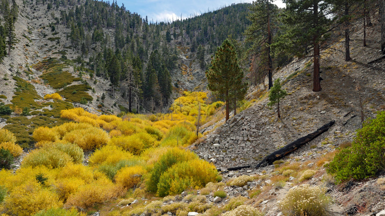
Southern California's forests are spread across a marvelous patchwork of mountains, canyons, and desert edges, home to delightful hiking opportunities like the scenic trail to Heart Rock Waterfall in the San Bernardino Mountains. A towering star of this region is San Gorgonio Peak (which locals used to call "Old Grayback"), California's tallest point south of the Sierra Nevada. You can venture up the tall mountain for unmatched views by way of the tough Vivian Creek Trail, though there are lots of picturesque lookouts in the mountain's encompassing area, designated as the San Gorgonio Wilderness. Made up of a variety of deciduous trees and home to California's southernmost aspen grove, the wilderness, with its multitude of trails, is particularly photogenic in the fall.
The San Gorgonio Wilderness comprises 81 miles of trails, including a portion of the Pacific Crest Trail, a popular yet deadly West Coast trail. It also has 24 free backcountry campsites and many more reservable sites at the San Gorgonio Campground. Whether you plan on staying overnight or coming to hike for the day, the wilderness is a pristine place to witness fall's glorious palette.
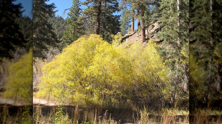
You'll get the best views at the aspen grove, located about 0.5 miles in on the Aspen Grove Trail. It might be a surprise to find aspens here, since they thrive in cooler regions, but the San Gorgonio Wilderness has a cooler climate than you might come to expect compared to other parts of Southern California. In the fall, the aspens' leaves turn golden-yellow and sometimes red, their vibrant color typically peaking in the first half of October. Alongside aspens, you'll also see some black oaks, big leaf maples, and sycamores ornamenting the trails with fall color.
How to explore the trails of the San Gorgonio Wilderness in autumn
There are a few different entry points to the San Gorgonio Wilderness, depending on which trails you're coming for. The Aspen Grove Trail has its own parking lot that's located off forest road 1N05. If you're flying in, the nearest commercial airport is the San Bernardino International Airport in San Bernardino, a popular West Coast city that also ranks as America's dirtiest. From the airport, it's about a 2.5-hour drive to reach the Aspen Grove Trailhead — just note that the forest road might be closed in the wintertime.
All hikers need a permit to enter the wilderness (other than some parts overseen by the Bureau of Land Management, rather than the Forest Service). Permits are free and can be reserved online, but they sell out fast during weekends in autumn. Once on the Aspen Grove Trail, you'll cross a creek and then turn right to reach the grove's heart within 0.75 miles. Several popular trails, including the Vivian Creek Trail, begin in Forest Falls, a small community that's just a 30-minute drive from the San Bernardino International Airport. If you want to brave the steep Vivian Creek Trail, September and October are the perfect months to do it.
From winter to early summer, the high elevation of the trail becomes dangerous because of fickle and extreme weather conditions, including fires. Meanwhile, the trail starts getting snow in mid- to late fall. The Momyer Creek Trail, just over 4 miles long and also starting from Forest Falls, is another great hike option for fall, when temperatures become more comfortable and the shimmering creeks are full.