Nestled In California's Big Sur Is An Iconic Bridge With Dramatic Views Overlooking The Pacific
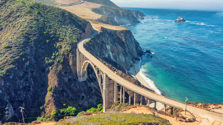
One of America's must-do experiences whether you're a resident or a visitor is a road trip along Pacific Coast Highway 1, which winds along the dramatic California shoreline totaling about 650 miles from Orange County through San Francisco to Mendocino County. But really, when most people picture Highway 1, they're probably thinking of the section that meanders through Big Sur and the Monterey area — with its craggy cliffs, foggy marine layers, towering redwood forests, city detours, and more — it's not only the most breathtaking stretch of the drive but one of the most beautiful destinations in America. A big reason you can make such a memorable trip is thanks to the Bixby Bridge, one of the most famous and most photographed bridges in the U.S. (a feat, considering there are more than 6,000 bridges around the country).
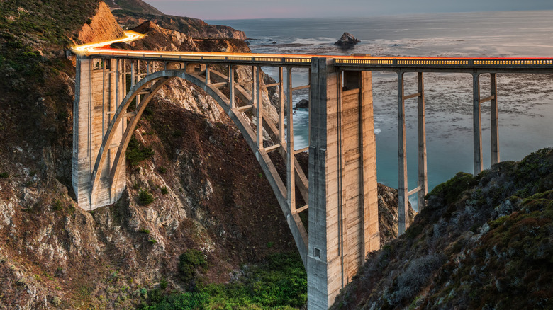
Bixby Bridge is an architectural marvel spanning Bixby Creek, tucked neatly between the striking Santa Lucia Mountains and overlooking the Pacific Ocean's crashing breaks. It's a world-class place to watch the sunset and take photos, or just gawk out the window while singing along to your favorite music at top volume as you cruise along. There are only 30 miles between Monterey and Big Sur, that magic space immortalized by John Steinbeck, Henry Miller, and Jack Kerouac, and highly recommended by modern travel aficionados like Samantha Brown. Today, you can easily drive through Big Sur in a few hours. But imagine taking three days to slog from Big Sur to Monterey — not to enjoy the scenery or make charming detours, but just to get groceries. That was the reality for central coast Californians prior to 1932, when Bixby Creek Bridge was built.
Bixby Bridge created new access for Californians
Prior to the existence of the Bixby Bridge, local residents were all but trapped during winter without direct access to the south. Old Coast Road, a stagecoach route, was an 11-mile, inland detour that was often impassable due to inclement weather or fog. Bixby Bridge changed all of that. Constructed from 1931 to 1932 and designed and engineered by F.W. Panhorst and C.H. Purcell respectively, the Art Deco-inspired reinforced-concrete structure almost matches the natural landscape and was a striking engineering feat for its time, connecting northern and southern California without tunneling through the Santa Lucia Mountains. If you're road-tripping down the coast, you'll certainly cross Bixby Bridge via Highway 1. It's located just 15 miles south of Carmel-by-the-Sea, a charming, historic village filled with delightful boutiques, and 15 miles north of Post Ranch Inn, a Big Sur eco-luxury resort in the cliffs high above the Pacific Ocean.
Because of the site's precarious location, the bridge had to be constructed between unstable cliffs above Bixby Creek by methodically shipping 45,000 sacks of cement and heavy-duty machinery up the mountains around single-lane switchbacks. Platforms, cables, pulleys, and slings did the heavy lifting. Against all odds, the bridge was finished in just over a year, five years before the road itself was even finished. It cost under $200,000 and, at the time, it was the tallest concrete, single-span arch bridge in the world. In 1965, Lady Bird Johnson designated Bixby Bridge as California's first scenic highway, and in the 1990s, the bridge was seismically retrofitted to withstand earthquakes. Today, it still stands as it was built more than 90 years ago — over 260 feet tall and 714 feet long.
Things to know about Bixby Bridge before you go
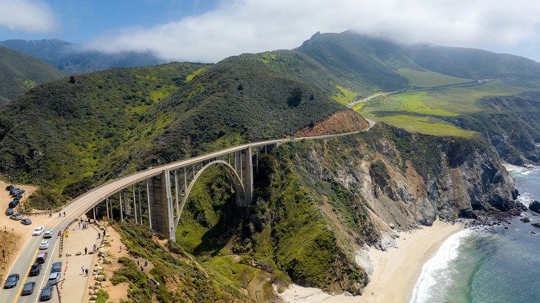
Though the bridge itself is still impressively standing after nearly a century of use, mudslides and erosion in the area have impacted local roads, including Pacific Coast Highway 1. In 2024, part of the highway just north of Bixby Bridge and south of Carmel collapsed during heavy rains, leaving hundreds of people stranded in their cars. After travelers were rerouted, parts of the highway were closed or reduced to one lane for more than a year as the road was repaired. Although the second lane reopened in the summer of 2025, part of Highway 1 about 25 miles south of Bixby Bridge is still closed. In 2021, another stretch of the road near Monterey also collapsed, thanks to mud and rockslides during heavy rains. The California Department of Transportation (CalTrans) monitors and fortifies the highways, so check the CalTrans website for the latest updates on road conditions before you set out on your drive.
Bixby Bridge doesn't get to be the most photographed bridge in America without crowds to photograph it, so keep that in mind, particularly if you're visiting at golden hour or sunset or in the peak summer months. There are a few turn-offs with limited parking, which are the only places you can pull over on the road as parking is not allowed on the shoulder. On the north side of the bridge, Castle Rock viewpoint is the safest spot to capture the curvature of the bridge, or you can drive to the Bixby Bridge vista point about a half-mile inland. There are no pedestrian sidewalks, so it's not possible to stand on the bridge itself to take photos.