Virginia's Longest Recreation Bridge Thrives In A Unique State Park With Renowned Trails And Deep History
If you were to list destination names that don't bother with subtlety, the Grand Canyon and the Great Salt Lake would land squarely at the top. But there's one name you've likely never heard of: Virginia's High Bridge Trail State Park, a moniker that leaves little to the imagination. At the park's heart lies the historic High Bridge, looming 125 feet over the Appomattox River, per Virginia Department of Conservation and Recreation. It's Old Dominion's longest recreational bridge, and the park it calls home is packed with renowned trails and deep history. It's also easy to reach, sitting around 70 miles away from Richmond, a historic center and hub of diverse entertainment.
According to Virginia's Heartland Regional Visitor Center, High Bridge boasts landmark status, earning the designation both from the state of Virginia and from the National Register of Historic Places. First built in 1853, it was once believed to be the longest bridge in the world, connecting Petersburg to Lynchburg, today a vibrant college city in the Blue Ridge Mountains foothills. The bridge once served as a key logistical artery and endured several attempts to destroy it during the Civil War to slow Confederate Army General Robert E. Lee's retreating forces. It ultimately hosted some of the final skirmishes of the war, preceding Lee's surrender.
The bridge was rejuvenated after the war, with trains continuing to cross it. It was eventually replaced by a steel version in 1914, and the piers and abutments that supported the original structure still stand today. All bridge use was discontinued by 2006, when the Norfolk Southern Railway Company donated a 31-mile chunk of the line it was a part of to the state of Virginia. Several years of restoration work later, the bridge opened in its current form in 2012.
Crossing Virginia's High Bridge
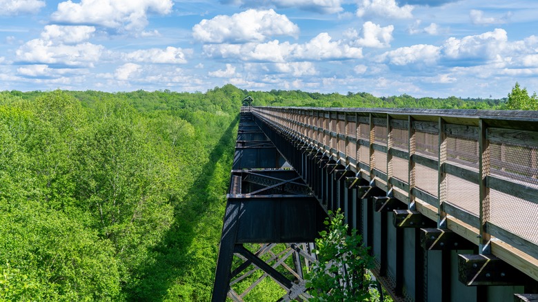
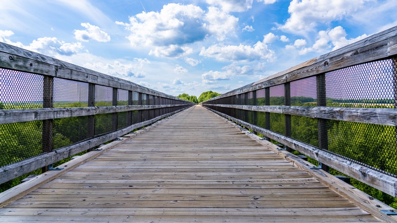
The park's eponymous trail is a 32.2-mile former rail bed. The trains are long gone, replaced by a crushed limestone path that has been recognized as a National Recreation Trail — a title reserved for outstanding treks that enable their communities to connect with nature. Part of a larger 40-mile network, the trail makes for a pleasant hike (or ride, if you're on a bike or horseback). The crown jewel of the park is its High Bridge, boasting a 2,400-foot span, making it the longest recreational bridge in the state. The big question is: Which trail in the park should you take?
Hikers with their most rugged boots should head over to one of the High Bridge Trail's offshoots. Nearly all are rewarding on foot. Those traversing the area on two wheels should consider the Deering, Burnside, or Early trails, which are ideal for mountain bikes. No hiker would have fulfilled their duties without going on High Bridge itself, taking in the scenery of the Appomattox River and surrounding forests and farms. Early risers should head over in the early morning for unobstructed sunrise views.
Visitors can start at High Bridge Station, a visitor center that offers a deep dive into the park's historic significance, giving some context for the visit and overall experience (it rather appropriately resembles a train station). Park rangers on hand can answer any questions and give guidance. You can reach it by heading to the parking lot east of the bridge on Camp Paradise Road, about a 13-minute drive from Farmville, a funky college town home to a bustling arts scene. Be sure to bring your own water, as there are no sources of it on the trail.