The 5 Best Trails To Explore The Bay Area's Breathtaking Point Reyes National Seashore
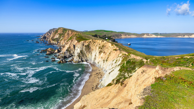
From aquamarine waves crashing against wildflower-covered cliffs, to elk-dotted grasslands, and hills that seem to fold into the ocean, Point Reyes National Seashore is the epitome of dramatic Northern California beauty. And one of its best attributes is its accessibility, located a bit over an hour north of San Francisco via the California coast's most immaculate Highway 1 drive, in Marin County.
Covering over 100 square miles, this preserve is blessed with pristine habitats and thriving wildlife, ranging from migratory gray whales and elephant seals to tule elk and even river otters. Visitors from across the Bay Area and further afield come for the natural beauty, coastal campgrounds, tidepools filled with critters, and the chance to snap a photo at the Point Reyes Lighthouse or the Instagram-famous Cypress Tree Tunnel. However, the network of over 150 miles of hiking trails is one of the main draws.
Whether you're completely new to hiking or a seasoned outdoor adventurer, you'll want to visit the trails at Point Reyes National Seashore again and again. With so many hiking routes spread over a sizable area, we've selected only the five best trails for visitors who want to make the most of their visit. Our selection process considered factors such as safety and trail maintenance, the prevalence of unique experiences and sights, and the (admittedly difficult-to-quantify) "wow factor" inspired by a truly impressive view. You'll also find hikes ranging from easy to moderately difficult, allowing everyone to enjoy Point Reyes National Seashore on foot. You can read more about how we came up with this list at the end of the article.
Tomales Point Trail
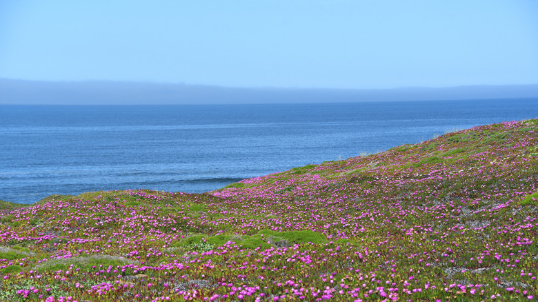
There's a reason the Tomales Point Trail is considered one of the best hikes in the Bay Area. Spanning 9.5 miles round-trip, the path showcases where gently rolling hills meet the wild Pacific Ocean. Experience views of Bodega Bay, Tomales Bay, and shrublands overflowing with wildflowers during the springtime on this trail, which takes between 4 and 5 hours to complete.
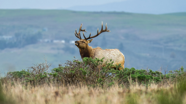
It's also a great place to spot local wildlife. In fact, you're almost guaranteed an elk sighting on the Tomales Point Trail. "I heard the alternating mating call of 2 Tule Elk mournfully baying unseen in the vicinity," shared one visitor on TripAdvisor. "It was haunting, wondrous, and completely unexpected. A wilderness experience you cannot plan for or expect but something you can only get at Pt. Reyes." And while it might be tempting to interact with the local wildlife, remember to give any animal you see (including marine mammals on the beaches) at least 150 feet of space for your safety and theirs.
Point Reyes is one of the foggiest places on the West Coast, so it should come as no surprise that the Tomales Point Trail is often socked in with fog. While it often obscures distant scenery, the tendrils of fog wrapping around the landscape create a softness and sense of mystique that's enchanting in its own right. Even with fog, you shouldn't underestimate the amount of water you'll need to bring. In addition, make sure to dress in layers, as the temperatures rise quickly when the fog burns off, and the bluffs get windy. When in doubt, check the weather forecast before hitting the trails.
Chimney Rock Trail
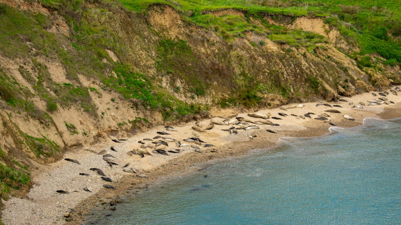
If you want to see northern elephant seals, harbor seals, and sea lions in their natural habitat, the Chimney Rock Trail is your best option. Short and sweet, this beginner-friendly path showcases the very best of Point Reyes National Seashore's impressive cliffs and is only 1.75 miles round-trip. It takes visitors along a cliffy peninsula, providing dramatic views of Drakes Bay and opportunities to see (and hear) colonies of elephant seals basking on the sands below. The path is relatively flat, and the incline won't wear you out, making it one of the top family-friendly hikes at Point Reyes National Seashore.
The best time to visit is in the spring (between March and April), but the seals are in residence from December to March. In the spring, not only will you see elephant seal pups, but the grasslands along the cliffs also come alive with brilliant wildflowers. Expect bursts of orange from California poppies and carpets of yellow-tinged lupine. Make sure to stop at Elephant Seal Overlook, which is only a 0.2-mile detour from the Chimney Rock Trail and close enough to the parking lot to be accessible for non-hikers.
Once you've had your fill of the seals' antics, follow the trail past the historic Point Reyes Lifeboat Station. From here, you can return to the parking lot or continue to Chimney Rock. This section of the trail can get quite gusty, and the cliffs are extra dangerous when obscured by fog. Always stay on the marked path and never attempt to scale the cliffs.
The Laguna-Coast Loop
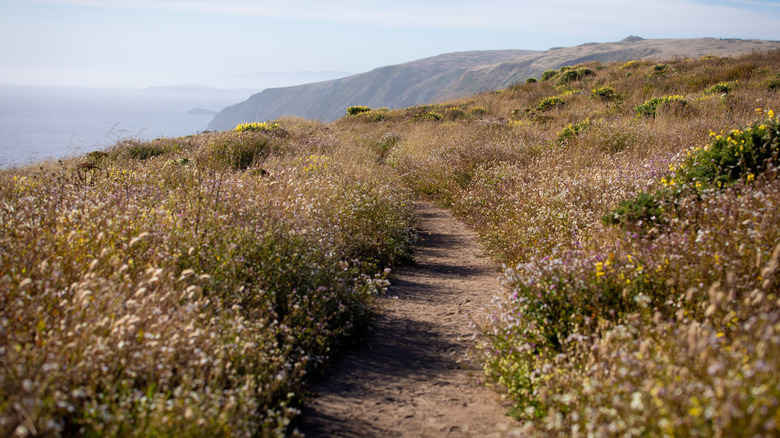
For the kind of ocean views that make people drive for hours and a route longer than the Chimney Rock Trail, take the Laguna-Coast Loop (sometimes referred to as the Coast-Laguna Loop). Measuring 5 miles round-trip, this is the Goldilocks of Point Reyes Trails—not too difficult, but filled with uninterrupted views from the headlands. The trail cuts through several premier Point Reyes habitats, including coastal shrublands and grassy bluffs — keep an eye out for deer, shady alder groves, and, of course, the windswept shoreline.
Enjoy views of Drakes Bay from above and access to Santa Maria Beach's empty shores from the wilderness camping at Coast Campground. Reachable only by foot, horse, or bicycle, the campground is everything a wilderness getaway should be. Remote and untouched, it offers 12 primitive sites within easy strolling distance of the ocean. Sites are available regardless of season and can be booked via recreation.gov.
Most hikers prefer to start clockwise from the Laguna Trailhead, but you can also begin your journey from the Coast Trailhead. Be mindful of your footing when hiking sections of the Laguna Trail, as a large crevice runs down the middle of the path. The 2.8-mile section that runs parallel to Drakes Bay has steep drop-offs. Keep a reasonable distance from the edge and only follow designated paths to the beach.
Alamere Falls via the Palomarin Trailhead

Unlike other featured hikes, this one is more about the destination, even though the journey takes you past Bass Lake's swimming holes, cypress-dotted hills, and miles of coastal views. But you have to walk over 13 miles round-trip for the experience. Alamere Falls is an example of rare "tidefalls," a type of cascade that tumbles directly onto the beach and into the sea. Pouring 40 feet down a jagged cliff onto Wildcat Beach, Alamere Falls is just as spectacular as McWay Falls, the famous tidefalls found at California's underrated Julia Pfeiffer Burns State Park in Big Sur.
In recent years, Alamere Falls has attracted more visitors (many of whom are unprepared for the long hike) thanks to viral videos calling it "California's most dramatic waterfall" and the "best waterfall in the Bay Area." The National Park Service (NPS) stresses that there is no park-sanctioned "Alamere Falls Trail" and that the "shortcut" mentioned in many blog posts is unsafe and damages the delicate ecosystem. In fact, Point Reyes National Seashore spokesperson Christine Beekman told SFGate that dozens of rescues per year result from people taking the "shortcut."
However, this doesn't mean the falls can't be reached. Instead, start from the Palomarin Trailhead, which connects to the Coast Trail and leads to Wildcat Beach. Next, and only at low tide, follow the beach until you reach the falls. You should plan to be out all day, or turn your trip into an overnight adventure by reserving a site at Wildcat Campground.
Abbotts Lagoon Trail

Known as one of the top birding destinations in the U.S., Point Reyes National Seashore offers numerous trails that will satisfy any birder. And, while Tomales Point and its elk are worthy of attention, the Abbotts Lagoon Trail is a hidden gem for wildlife spotting. Winding lazily through Abbotts Lagoon and over the coastal sand dunes, this 2.8-mile round-trip path leads from the trailhead at Pierce Point Road all the way to the coast.
The windswept dunes provide nesting areas for threatened western snowy plovers in spring and early summer, so mind your step and stay clear of restricted areas. Abbotts Lagoon is also home to one of the world's only groups of river otters known to hunt pelicans. If you're lucky, you might spot these North American river otters successfully capturing and eating brown pelicans. However, most birders will be satisfied with the variety of shorebirds and birds of prey, such as white-tailed kites.
The trail itself is easy and counts more as a stroll than a hike. The mostly flat path skirts the lagoon's edge and includes a small wooden bridge over the wetlands. Once you reach the dunes, the trail disappears, but it's easy to follow the sound of the waves to the water's edge. If you're looking for peace and quiet, this is the trail for you.
Methodology
In order to trim the fat, so to speak, and only choose the very best hikes at Point Reyes National Seashore, we selected trails with experiences that are unique to the area. For example, you might be able to see river otters somewhere else, but you'd be hard-pressed to witness these critters hunting pelicans in another lagoon. As mentioned previously, we also considered overall safety and trail maintenance.
Our research relies heavily on insights provided by the National Park Service, the Point Reyes National Seashore Association, regional tourism authorities such as Visit California, and local news sources like SFGate. The author's experience hiking at the preserve (she is a Bay Area native) and firsthand accounts from travelers on Reddit, TripAdvisor, AllTrails, and hiking Facebook groups further fleshed out our ranking.
Before starting your hike, make sure to check the National Park Service for trail closures and announcements. If you plan to visit during a superbloom or annual migratory event, check the park's Facebook page for updates or call 415-464-5100 to speak with a ranger.