The 5 Longest Hiking Trails In America With Ridiculous Distances

The United States is very much a land of hiking. With its vast size — much of it protecting stunning national parks, underrated state parks, and other public lands — the country offers trails through nearly every terrain imaginable. Not only that, but U.S. parks and hiking routes run the full spectrum of length and difficulty levels, from short, easy strolls to technical treks over rugged mountain peaks. Some trails even allow dogs.
Still, most U.S. trails, epic as they may be, are doable in a single day. Many are only a few miles long, and most hikers of average ability can complete them in a few hours at most. That is not always the case, though. Given the sheer size of the country, some American hiking trails go beyond a single-day hike and enter the realm of multi-day, overnight expeditions. With so much space to cover, a few trails go even further and hit lengths that nearly defy belief.
Believe it or not, the United States has several well-maintained trails and informal hiking routes that stretch for thousands of miles. Even more remarkably, many are popular within the hiking community, with ambitious adventurers setting aside several weeks — or months — to walk an entire route from end to end. These mega-trails typically cross multiple states and follow a specific geographic region, historic route, or other unifying theme. Then again, there are a few that are simply long. While intrepid hikers can find several formidable trails covering vast distances, these five developed trails are the longest in America.
The Appalachian Trail

The Appalachian Trail is arguably the most famous long-distance trail in the United States, so some travelers may be surprised to learn that it isn't the nation's longest. Still, at roughly 2,190 miles, it's certainly no slouch when it comes to length. According to some estimates, the Appalachian Trail is the longest hiking-only trail in the world, and, at the very least, earns the No. 5 spot on the list of longest U.S. trails.
Officially known as the Appalachian National Scenic Trail, the route is a comprehensive thoroughfare of the Appalachian Mountains. Such terrain allows the trail to live up to its "scenic" title, with virtually every mile surrounded by mountain summits, dense forests, lush meadows, and waterfalls. Hikers must contend with prominent Eastern peaks, including Tennessee and North Carolina's Kuwohi (formerly Clingmans Dome), Virginia's Mount Rogers, and New Hampshire's fearsome Mount Washington. Despite nearly 500,000 feet of total elevation gain, many hikers find the trail's beauty well worth the effort.
The trail also showcases the landscape of 14 different states, beginning in Georgia and traveling north through North Carolina, Tennessee, Virginia, West Virginia, Maryland, Pennsylvania, New Jersey, New York, Connecticut, Massachusetts, Vermont, and New Hampshire, before finally ending at Baxter State Park in the northern woodlands of Maine. Along the way, it passes through Great Smoky Mountains and Shenandoah National Parks, West Virginia's Harpers Ferry, New York's Harriman State Park, and New Hampshire's White Mountain National Forest, among many others. The trail also passes lookout spots, like the much-photographed McAfee Knob near Virginia's scenic Blue Ridge hideaway, Catawba.
The Pacific Crest Trail
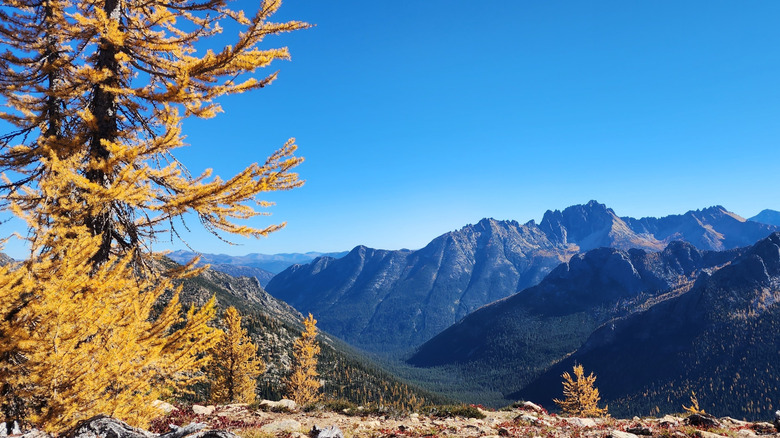
The Pacific Crest Trail is considered the Appalachian Trail's West Coast counterpart. Although it crosses just three states, their scale makes the route longer overall. The trail's full length is around 2,650 miles, spanning the distance between America's borders with Mexico and Canada, making it the fourth-longest hiking route in the country.
Like the Appalachian Trail, the Pacific Crest Trail is designated as a national scenic trail for its outstanding natural scenery. Unlike its eastern counterpart, however, it's not limited to a single mountain range. From the Mexican border, the trail climbs through Southern California's Laguna, San Jacinto, San Bernardino, and San Gabriel mountains, while making stops at public lands like Anza-Borrego Desert State Park along the way. From there, the trail moves into the Sierra Nevada of Central California, passing through Sequoia and Yosemite National Parks and skirting towering peaks like the 14,505-foot Mount Whitney.
In Northern California, the trail leaves the Sierra Nevada and enters the volcanic Cascade Range of the Pacific Northwest, passing Lassen Volcanic National Park and Mount Shasta. It continues for over 1,000 miles through Oregon and Washington, passing iconic Pacific Northwest features such as Crater Lake National Park, Mount Hood, the Columbia River Gorge, Mount Rainier, and North Cascades National Park. The American portion of the trail ends at the Canadian border, but the route does connect to the Windy Joe Trail in British Columbia's E.C. Manning Park, if hikers want to make it an international journey as well.
The Continental Divide Trail

If the Appalachian and Pacific Crest Trails are north-south hikes along both of America's coastlines, the Continental Divide Trail is the analogous long-distance trail in the country's interior. The namesake continental divide is the expansive hydrological divide between North America's Atlantic and Pacific watersheds. Like the Pacific Crest Trail, it spans the distance between the U.S. borders with Canada and Mexico. With a total length of around 3,100 miles, it is the third-longest single trail in the country, and the longest of the three so-called Triple Crown trails.
The Continental Divide Trail takes a more rugged, remote route than its coastal counterparts. It begins in the Chihuahuan Desert of southern New Mexico and travels northward through Colorado, Wyoming, Idaho, and Montana, before ending at the Canadian border near Alberta, where hikers may optionally continue north via connecting Canadian trails.
Along the way, the trail passes through some of the Mountain West's most stunning public lands. It traverses New Mexico's El Malpais National Monument, enters the southernmost extent of the Rocky Mountains, and then spends roughly 800 miles crossing Colorado's high country, including passages in Rocky Mountain National Park, the Collegiate Peaks, and the Never Summer Wilderness. Further north, the trail reaches its crescendo as it passes through acclaimed national parks like Wyoming's Yellowstone and Montana's Glacier, eventually meeting Canada's Waterton Lakes National Park at the border.
The North Country Trail
At approximately 4,800 miles, the North Country Trail is the longest trail in the United States with an official national scenic trail designation. Unlike the previous three national scenic trails on this list, this one doesn't highlight a specific geological feature; instead, it weaves together a wide range of northern landscapes.
Beginning in the northeastern woods of Vermont, the North Country Trail heads west across the Mid-Atlantic and Upper Midwest, crossing through New York, Pennsylvania, Ohio, Michigan, Wisconsin, Minnesota, and North Dakota. While this may seem like a random hodgepodge of states, the route actually offers an immersive adventure through some of the country's more underrated regions — from the mountains of New England and Upstate New York to America's Great Lakes shorelines, and finally to the vast grasslands of the Dakotas.
The North Country Trail is also a superb showcase of overlooked parks across the northern U.S., including Allegheny National Forest in Pennsylvania, with its old-growth hardwood forests, recreation-rich lakes, and extensive network of shorter trails. Further west, it becomes a gallery of Ohio's even more underrated public lands, including Hocking Hills State Park and Wayne National Forest. As it turns north towards the Great Lakes, it hits many of the country's popular lakeside destinations, including Michigan's Pictured Rocks National Lakeshore, Wisconsin's Chequamegon-Nicolet National Forest, and Minnesota's Boundary Waters Canoe Area Wilderness. While much of the route consists of hiking trails through natural areas and parks, some segments follow roads and other modern infrastructure, notably the massive Mackinac Bridge connecting Michigan's Lower and Upper peninsulas.
The American Discovery Trail

Unlike the other trails on this list, the American Discovery Trail is not an official national scenic trail. But while it lacks federal recognition, it has been developed, maintained, and used enough to qualify as a singular, recognized "trail." Clocking in at approximately 6,800 miles, it is the longest established trail in the United States and the first coast-to-coast hiking trail, linking America's Atlantic and Pacific coasts. Between these two oceans, the trail crosses 15 states and Washington, D.C., numerous national parks, several acclaimed cities and small towns, and other notable long-distance trails, including the Appalachian and Pacific Crest trails.
The American Discovery Trail begins at the Atlantic shoreline in Delaware's historic Cape Henlopen State Park. On the other side of the country, the trail ends (or begins) at the secret beaches and lagoons of California's utopian Point Reyes National Seashore. In between, it covers several thousand miles in four distinct regions. The Eastern States Region includes passage through Maryland and Washington, D.C., as well as the mountains of West Virginia and Kentucky. On the opposite end, the Western States Region traverses the Rocky Mountains and the continental divide of Colorado and Utah, Lake Tahoe on the Nevada-California border, and the rugged Sierra Nevada before reaching the Pacific. In the Midwest, the trail splits into two different routes: a North Central Region through northern Indiana, Illinois, Iowa, and Nebraska, and a South Central Region through southern Indiana, Illinois, Missouri, and Kansas. The American Discovery Trail with the South Central Route is slightly longer than with the North Central Route – 5,008 miles to 4,844 miles, respectively – but either option is still longer than any other single trail in the country.
Methodology

Compiling a list of the longest trails in the United States and ranking them based on length is more difficult than it may appear. While official length figures exist, precise measurements can be tricky to calculate with 100% accuracy, thanks to variations in the infamous coastline paradox. As a result, different sources sometimes report slightly different totals.
Another challenge was determining what constitutes a "trail" in the first place. Avid hikers in the United States have several notoriously long hiking routes that they develop and maintain on their own, and new long-distance hiking routes are always popping up as more enterprising hikers forge new pathways. A few of these unofficial routes are even longer than the five trails on this list. For example, the hiking community has recently sought to establish the 4,455-mile Great Western Trail, the 5,400-mile Eastern Continental Trail, and the 6,875-mile Great Western Loop. However, as of early 2026, these routes are still informal networks of previously established trails rather than singular trails in their own right. For our list, we limited our search to trails recognized by a public or reputable private entity. Conveniently, four of these trails are officially designated as national scenic trails. The American Discovery Trail, while not federally recognized, has sufficient non-governmental recognition to qualify.