The 5 Most Scenic Trails In Big Sur's Julia Pfeiffer Burns State Park
If images of a waterfall plunging onto a pristine beach kissed by frothy waves come to mind, you're likely thinking of Julia Pfeiffer Burns State Park in Big Sur, California. This iconic park is home not only to McWay Falls but also to a web of trails, leading hikers through peaceful redwood groves, over coastal canyons, and up towering ridges so high the Pacific Ocean's wild waves look like tiny ripples.
The park's website identifies seven official trails, but several are connected, allowing visitors to create longer hikes. Our recommendations take into account the scenery along the trails as well as the famous viewpoints or midway stopping points. We prioritize well-maintained, safe trails that remain fully in nature, rather than those that include a long section along the highway.
You'll need to check for road and trail closures before planning your trip. One of the most useful resources is the Big Sur Trailmap. Run by a local hiker with a deep passion for the area, the site has some of the most up-to-date information on trail closures as well as downloadable maps and trail suggestions. The Canyon Trail, McWay Falls Overlook Trail, and part of the Ewoldsen Trail remain closed at the time of writing. Currently, Julia Pfeiffer Burns State Park can be reached via Highway 1, about 40 miles south of Monterey. It's just a 1-hour drive from Cannery Row's famous oceanfront shops and Carmel's beaches and boutiques.
Ewoldsen Trail
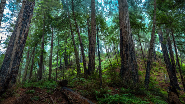
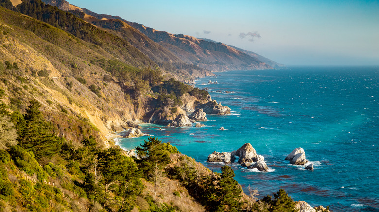
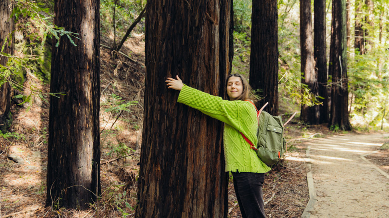
In many ways, the Ewoldsen Trail is the quintessential Big Sur hike. Stretching 5 miles, it gives visitors who don't mind an incline a taste of epic coastal views, redwood groves, creeks, and waterfalls, and the sense of being in a place that holds a little bit of magic. If you ask people from the greater Big Sur area to choose their favorite day hike, the Ewoldsen Trail will be at the top of many lists.
Although technically a loop, the eastern section that follows McWay Creek has been closed since the Dolan Fire in 2020. This makes the Ewoldsen Trail a moderately difficult out-and-back trek. You'll head up a steep slope, winding between coastal redwood communities dressed in a green carpet of sword ferns and sorrel, until you reach a high ridge. Near the end of the out-and-back section, take a rest at a humble bench with a bird's-eye view of the neighboring redwood-covered hills. From here, this particularly rough stretch of the Pacific Ocean looks as calm as a lake. The hike is definitely a workout, and some hikers recommend bringing trekking poles, but it's not a huge push for hikers used to steep grades. Plus, the trail is well-maintained.
This trail is considered one of the best trails to spot a condor in Big Sur. Famed for their 9.5-foot wingspans, these prehistoric-looking birds are incredibly rare — there are only about 350 left in the wild — and they occasionally make appearances over these ridges.
McWay Falls Overlook Trail
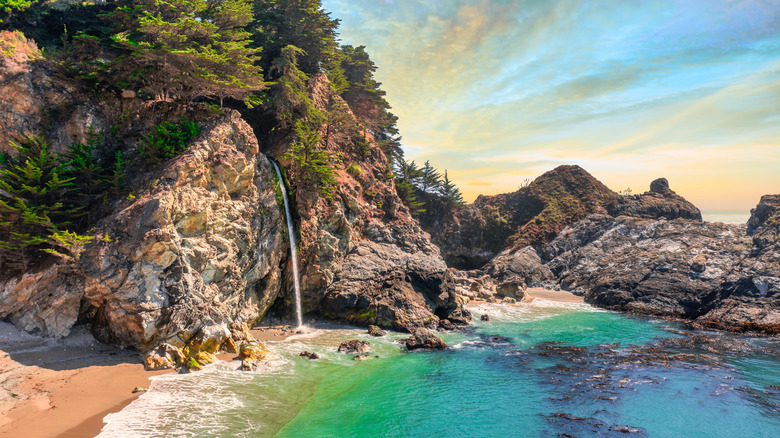
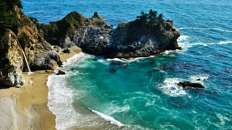
Although the McWay Falls Overlook Trail will remain closed into 2026 due to serious path repairs, it's undeniably one of the most scenic trails in Julia Pfeiffer Burns State Park. The trail itself is short (only 0.5 miles round-trip), wheelchair accessible, and will hopefully have a brand-new retaining wall when it reopens. However, the view of McWay Falls from the granite cliffs is the main attraction. You'll expend just a tiny bit of energy during the hike, and the reward is most definitely worth it.
Starting at the McWay Dayuse Parking Lot, you'll stroll under Highway 1 before the path takes you to the McWay Falls Overlook. Perched above McWay Cove's aquamarine waters, you'll spot the 80-foot waterfall plunging from the cliffs. Starting 3,000 feet above in the Santa Lucia Mountains, McWay Creek plummets from the redwood-topped cliffs like water out of a faucet, before spilling onto the untouched sand and rushing into the ocean. There's no beach or waterfall access, which allows visitors to enjoy McWay Cove like a living landscape painting — unblemished by trash or even footprints.
Even though it might be tempting to take a peek at the falls off-trail, it's not worth it. Several people have lost their lives illegally exploring the area, including a 20-year-old hiker who fell from the cliffs and drowned in 2015.
Tan Bark Trail
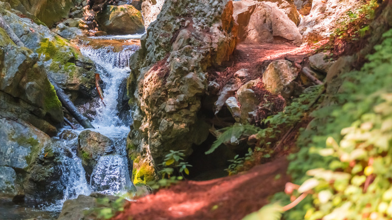
Following a path shaded by redwoods along Partington Creek, the Tan Bark Trail (3.2 miles one-way) offers one of the most magical river hikes in Big Sur. Water trickles over stones, while sword ferns and thimbleberries soak up splashes of dappled sunlight. But this is only part of the hike. Next, the path continues to wind through redwoods and grassy areas, before reaching switchbacks up the impossibly tall ridges with classic Big Sur ocean views. Not for casual strollers, the trail climbs from approximately 200 to 2,200 feet,
Hikers depart from the turnout for Partington Cove on Highway 1 and reach the end point at Tin House Road, a fire road that hikers are allowed to access. If you don't want to hike back the way you came, take the Tin House Road down the mountain, creating a 6.7-mile loop. However, there's a downside — you have to walk along Highway 1 to get back to the starting point, which isn't a relaxing way to finish your hike.
Pro tip: Pack a lunch and eat your meal at the ruins of Tin House. Constructed during the material shortages of the World War II era, the house is actually two gas stations that a former congressman dragged up the mountain. Here, you can enjoy views of the surrounding mountains and ocean from a vista point high above the fog line. You'll encounter the Tin House where the Tan Bark and Tin House Trails intersect.
Tin House Road
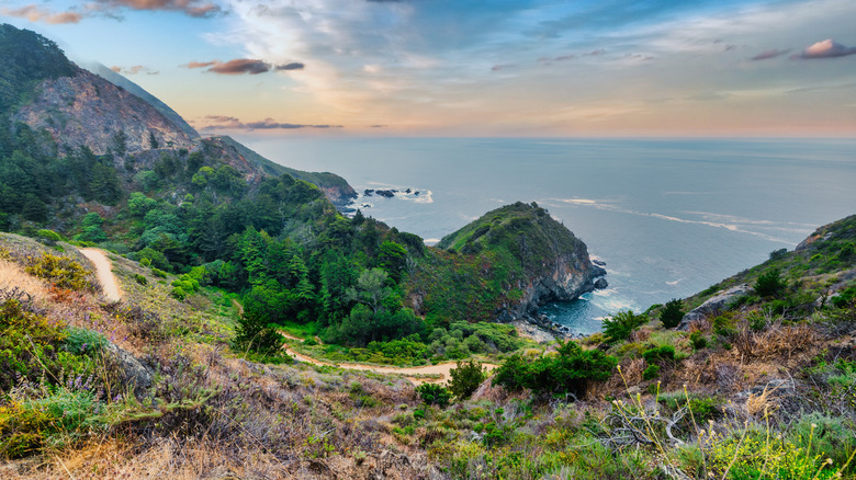
Another way to see the mysterious Tin House,and the views that go with it, is by following the 2.3-mile Tin House Road (the fire road mentioned in the previous entry) as an out-and-back hike. The trailhead isn't super well-marked, but you can find it by following directions to the Julia Pfeiffer Burns State Park Vista Point on Highway 1. Take a moment to spot McWay Falls in the distance and, during winter, look for gray whales on the horizon.
The entrance to the fire road lies slightly south of the vista point, on the ridge side of the highway. You can find it by looking at Google Street View, but it doesn't have a specific location. Be very careful when you cross Highway 1, as drivers are often distracted looking at the views and don't expect people crossing in this area. Showcasing panoramic views of the coast, the Tin House Road is more of a dirt path, lined with geasewood and a few tufts of pampas grass. You'll start out with an intense upward climb, and the trail keeps going up and up until you reach the Tin House. In one word, it's challenging.
Although completing the Tan Bark Trail and Tin House Loop gives you new scenery the entire time, taking only the Tin House Road means you walk on Highway 1 for a very short distance. In practice, it's more like crossing a dangerous street than actually hiking along the highway.
Partington Cove Trail
If you're looking for a short hike with a ton of variety to break up your awe-inspiring California Highway 1 road trip, the 1-mile-long Partington Cove Trail is perfect. Starting from the Partington Cove turnout, this former wagon road leads to three points: Partington Cove, Partington Creek, and a secluded bench overlooking the deep blue water. You'll also encounter an old timber tunnel, a quaint wooden bridge, clumps of redwoods, and wild paths weaving along the coast
Filled with the clearest water and mussel-covered rocks, the cove once served as a makeshift landing for timber before the highway was carved into the cliffs. In the late 1800s, the oaks that gave the Tan Bark Trail its name were harvested for their tannins, a substance used to tan animal hides, and dragged to the cove.
Although the trail is short, the incline is steep, and many visitors find the route challenging. "It is a strenuous hike," relayed one hiker on Tripadvisor. "Going down is easy, but going up could be tough; make sure you are in good shape." Before starting out, apply sunscreen and wear a hat as the path to the cove is unshaded and you can still get a burn, even on a foggy day.
Methodology
Although scenic is a subjective term, we selected these trails based on how well they exemplify classic Big Sur beauty. Think expansive ocean vistas, towering ridges nearly barren in their splendor, redwood groves, and bubbling waterfalls or creeks. We selected trails that provide a safe hiking experience. However, we can't stress enough that trail conditions change quickly: You need to be prepared for fallen trees and erosion, and always check the park website for trail closures.
Our recommendations are based on the first-hand experience of the author, a Bay Area native who has spent extensive time camping and hiking along the Big Sur Coast. She has hiked every trail in this park except the Waters Trail and the end of the Tin House Road.
In addition, our research includes trail information, updates, and statistical data from California State Parks, Big Sur Trailmap, and the Big Sur Chamber of Commerce. AllTrails, Reddit, Google Reviews, Tripadvisor, and testimonials from regional hiking groups and prominent travel bloggers also informed these recommendations.