Tennessee's Jaw-Dropping Waterfall At The End Of A Gorgeous Mountain Trail Is An Easy Knoxville Day Trip
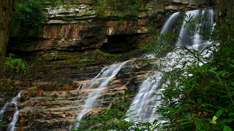
As a mountain range that's become synonymous with hiking, it's no surprise that the section of the Appalachians within Cherokee National Forest hosts some incredible trails, with picturesque lookouts, scenic forests, and numerous waterfalls. One of the most beloved hikes in the Cherokee National Forest is the Margarette Falls Hike. Head 1.5 hours (81 miles) east from Knoxville to Greeneville for a fun day of splashing and relaxing at the foot of the fan-shaped waterfall as it empties into West Fork Dry Creek (aka Dry Creek).
Despite its popularity, the Margarette Falls Hike retains a remote, isolated vibe. Most of the trail is pretty strenuous but scenic, featuring a winding, uphill path along a bubbling creek through pretty forests, with cascades and flowers sprinkled throughout. Margarette Falls is one of the few waterfalls in the area that generally runs even on dry days, making it one of the best year-round waterfalls. As a result, you're unlikely to find crowds jostling for space on the trail; everyone knows that they can see the waterfall anytime they please. However, if you really want to enjoy Margarette Falls in isolation, avoid the weekends and holidays.
Those who brave the steep, rocky paths are treated to a 60-foot waterfall and a pool that stays cool and clean even on a muggy day. The entire out-and-back hike is around 2.5 miles, with a 626-foot elevation gain. It's rated moderate on Alltrails, although isolated reviews on Google and Tripadvisor claim the trail is far more strenuous than its "moderate" tag would suggest. However, even those reviews decrying the trail's "moderate" rating agree that the scenic forest views, mini-waterfalls and cascades along the trail, and the beauty of Margarette Falls are worth the wobbly knees and aching muscles.
The route to Margarette Falls
The Margarette Falls Hike begins a few miles south of the funky, artsy town of Greeneville, just off the Shelton Mission Road parking lot. The first half-mile of the trail is an easy walk along a wide, gravel path until you reach a fork off the road. Turn right here onto a narrower dirt track to stay on the trail. At the second fork, turn left. Don't worry about getting lost; the hike is well-marked, with clear signage at every fork.
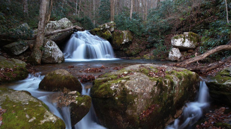
Past the second fork, you'll be walking on muddy, sometimes slippery paths along the pretty cascades of Dry Creek for the rest of the trail. A third of a mile later, you'll reach a bridge crossing over Dry Creek, and that's where the trail really amps up its difficulty. The path past the bridge is incredibly rocky and steep, featuring several sections with tall steps or loose rocks. Around 0.2 miles past the bridge, there's another creek crossing, this time with no bridge. On dry days, you might be able to hop across without getting your feet wet, but chances are your shoes will at least get slightly wet here, so we suggest getting some solid, waterproof hiking boots. If you don't have any shoes suitable for this hike, this list of the most popular hiking shoe brands is a good place to start.
Around 0.2 miles past the second creek crossing, you'll reach Margarette Falls. Cool off in the clear pool at the foot of the waterfall, take pictures, and enjoy the serene ambiance before heading back the same way. If you want to turn this day trip into a weekend vacation, consider visiting Tennessee's highest alpine lake for swimming, fishing, and kayaking, just 70 miles east of Margarette Falls.