11 Beautiful, Flourishing Downtowns Brought Back To Life After Being Ruined By Freeways
In the mid-20th century, the United States saw the rise of freeways, connecting the country from end to end. However, many of these freeways harmed communities — impacts that are still strongly felt today. Not only did these urban highways displace thousands during construction, primarily Black families, but they also reduced land values, increased economic and racial segregation, and elevated exposure to shocks and stresses. According to the Urban Land Institute, studies show that living near a freeway can harm your health, as well as contribute to climate change, reduce pedestrian safety, decrease investment in public transport, and even exacerbate extreme weather.
There's a growing movement to replace these urban highways with boulevards and/or green spaces. In several successful examples of this, the city that removed the highway benefited in numerous ways, according to the Congress for New Urbanism, a pioneer of the "Highways to Boulevards" movement (H2B). And now is the time, as many of the current freeways, especially in the United States, are aging and in need of extensive, expensive repairs. Removing these freeways can improve community ties, increase economic prosperity, improve local health, and decrease environmental impacts from the roads. And while it's not as simple as tearing all highways down, it can be done — and done well.
This article tells the story of 11 successful highway removal projects across the globe, from Boston to Madrid, which replaced congested freeways with parks, boulevards, waterways, and other community-building features, all with positive outcomes on the surrounding city.
Boston
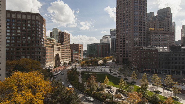
Boston is one of the most famous stories on this list, with the Central Artery highway that limited access to the waterfront and cut off various neighborhoods from downtown being turned into a massive underground tunnel during the "Big Dig." Although pricey, the Big Dig was ultimately a success, as the Rose Kennedy Greenway, the linear park that now stands in its place, can attest.
Nowadays, the Rose Kennedy Greenway, a stunning green scene with public art and gardens in the heart of Boston, is 17 acres that links Boston's downtown to neighborhoods that were once effectively cut off by the former Central Artery highway. That highway, which was built in 1959, displaced 20,000 residents and physically cut off neighborhoods like the North End and Waterfront from the rest of the city. In the mid-1990s, the "Big Dig" began, and while the project ultimately took much longer than originally estimated, it has undoubtedly improved Boston, replacing the Central Artery with an underground expressway that leads to a bridge crossing the Charles River.
Although the removal of the Central Artery was expensive (the most expensive highway project in the country's history, in fact), and didn't have perfect outcomes (promised public transportation replacement never arrived, for example), it still had enormous benefits. There's the greenway, of course, but the "Big Dig" restored Boston's Waterfront, and it's estimated that through thousands of new housing spaces, millions of square feet of commercial space, and over 40,000 new jobs, billions of dollars have been invested in the area (via Congress for New Urbanism).
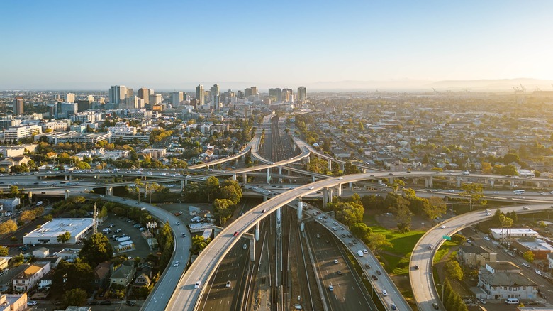
Oakland
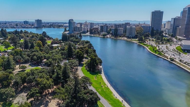
Oakland, California, was once home to the Cypress Street Viaduct, the first "double-decker" freeway in California, originally opened in 1957. However, the devastating Loma Prieta Earthquake (magnitude 7.1) in 1989 caused the complete collapse of the viaduct in several sections. This allowed the city of Oakland to partially restore the West Oakland neighborhood, severed and cut off from the rest of the city by the viaduct in the 1950s. Rather than reconstruct the freeway, Oakland rerouted much of the road to a more industrial area and turned part of it into the 1.3-mile Mandela Parkway. The parkway includes walking paths, bike lanes, green spaces, hundreds of trees, and has spurred dozens of new businesses.
In addition, between the establishment of the parkway between 1990 and 2010, the area of West Oakland saw fewer instances of poverty, an increase in household income, and a reduction in harmful pollutants like nitrogen oxide and black carbon levels. This has improved health outcomes for residents, according to the people-first transportation initiative, Our Streets.
However, the project has had it's problems as well. Much of the freeway was simply moved, and rising costs in the Bay Area have pushed many out who may have benefited from the changes. But overall, the positives are numerous since the parkway supports a walkable, connected community.
Portland
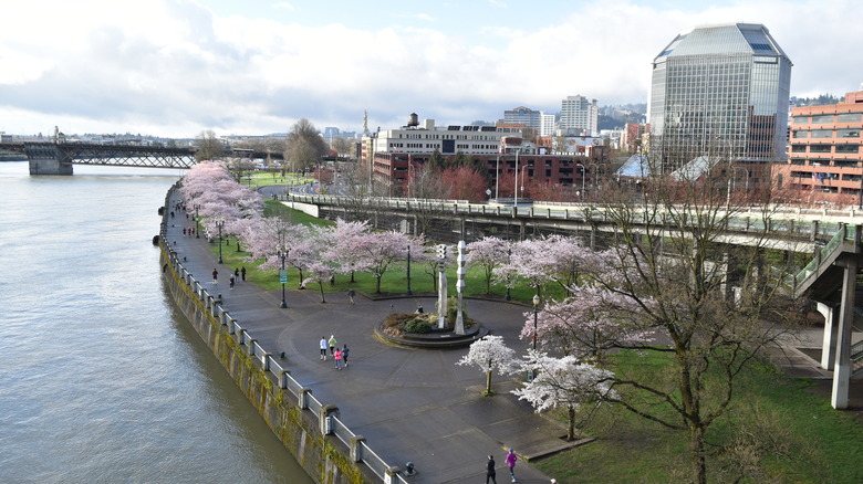
Portland, Oregon, is renowned for its beauty, particularly along the banks of the Willamette River. Yet the popular, lively Waterfront Park was once Harbor Drive, a busy, six-lane highway. In the history of freeway removal projects, Harbor Drive is the first in the United States to be intentionally removed rather than removed out of necessity.
Harbor Drive, a section of Route 99, was constructed in the 1950s, following the path of the Willamette River through downtown Portland. As other roads were built, Harbor Drive was used less and less. Eventually, a coalition called the "Riverfront for Citizens" called for its removal. Backed by Oregon Governor Tom McCall in the late 1960s, citing a beautification initiative, the freeway was demolished in 1974.
In 1978, Naito Parkway, constructed for local traffic, was opened, along with the new, 37-acre Waterfront Park. The success of the park was so great that in 1999, Portland enlarged the park by almost double. To this day, residents see the benefits. The waterfront area was revitalized, and property values continue to increase, along with a resurgence in downtown housing. And at the crux of it all, Portland's river access remains nearly unmatched, adding an invaluable amenity and improving the quality of life for its citizens.
Seoul
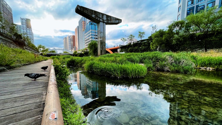
When you discover the beautiful Cheonggyecheon in Seoul, South Korea, you'd never realize that this lovely waterway was once a freeway — unless you stumble upon the sections of the park where a few freeway pillars remain as symbols of what once was. Even so, the surrounding paths, greenery, and water make it hard to imagine that this was once the Cheonggye Freeway; the loudest, most congested, and most polluted area in the capital (and all this just three decades after the freeway was built, in 1968).
As part of an urban renewal strategy in the early 2000s, Seoul's mayor advocated removing the freeway and installing a green space, in addition to daylighting the creek that had once flowed through. In 2005, the 5-mile-long (9 kilometers) Cheonggyecheon, full of trees, paths, and that long-lost (now man-made) stream, opened to the public.
Flooding has eased thanks to the open watercourse, and summer temperatures have decreased in the area by an average of 3.3 degrees Celsius (about 5.94 degrees Fahrenheit) per year. Wildlife has returned to the area, and tourists flock here —it's even one of the city's most visited tourist attractions, with about half a million visitors a week. The success of Cheonggyecheon has spurred Seoul to remove 14 other such freeways throughout the city, which has, in turn, increased use (and need) for public transit. Overall, Cheonggyecheon is an inspirational story of how we can bring back what freeways have taken away.
Chattanooga
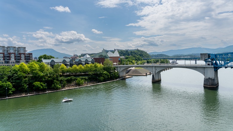
Don't sleep on Chattanooga, Tennessee, which is a scenic Southern gem with trails, river views, and lush green spaces. It wasn't always this way, though. In 1969, Walter Cronkite called Chattanooga "the dirtiest city in America," thanks to its congestion and industrial smog (via the Urban Land Institute). The city had a plan for revitalization, though, and a key part of this plan was freeway removal, especially dismantling the Riverfront Parkway. Built in the 1960s, it blocked the city from the river, in addition to bringing in huge amounts of traffic, pollution, and noise.
The parkway was transformed into a more pedestrian (and bike) friendly boulevard in the early 2000s, revitalizing the entire riverfront and downtown area. Since 1990, the population of this once-declining city has grown by 30%, and now the waterfront is one of the city's most desirable areas. Millions of dollars have been invested in the area, and efforts to make the new boulevard a green space have paid off, with the addition of a waterfront park, pedestrian crossings, and plenty of trees.
"What Chattanooga has now is a very attractive, walkable downtown that has all the amenities ... good public education, a good university, lots of ongoing public-private partnerships, new and revitalized parks with activation, and a downtown riverfront park," notes Leigh Ferguson, a local non-profit housing developer, to the Urban Land Initiative. The city's removal of Riverfront Parkway and dedication to urban renewal have enabled Chattanooga's downtown to thrive.
Paris
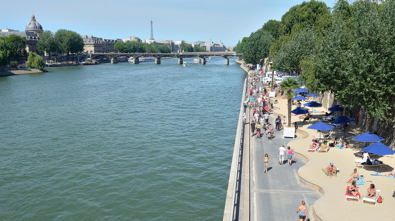
Paris' River Seine is so iconic, it seems a crime to have its banks lined with a freeway, yet this was the case with the Pompidou Expressway. One mayor experimented in the early 2000s with closing part of the expressway and creating a temporary beach along the riverbanks. This continued until 2012, when the expressway was permanently turned into a smaller boulevard, beach, and promenade, giving locals easy access, once again, to their beloved river.
The UNESCO-listed Seine is an iconic feature of Paris that was cut off from the city via the Pompidou Expressway in 1967, running along the banks through the city for over 8 miles (13 kilometers). In 2001, a new progressive mayor, running on a platform of increasing public transportation, proposed the idea of turning the Pompidou Expressway into a beach along the Seine. In 2002, the expressway was closed during the day for a month in the summer, which was enthusiastically embraced by Parisians. Finally, in 2012, the closure was made permanent, and both banks of the Seine now include public spaces like a promenade, sporting areas, playgrounds, event barges, and a floating garden.
This has been such a success that Paris recently voted to make at least 500 more streets of the city car-free, which will change how visitors to this iconic vacation destination experience its streets. Although this is a controversial plan, most approve of Paris's continued efforts to decrease car usage throughout the city. As one local official told The World from PRX: "Every Parisian is quite conscious of the fact that there [are fewer] cars, that there is less congestion, that there is better air quality, and that the overall quality of life has really improved."
Rochester
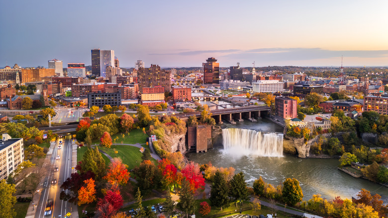
Rochester, New York's Inner Loop freeway is an example of how a freeway can physically isolate neighborhoods, demonstrably impacting outcomes and success of the individual sections and the city as a whole. Rochester's downtown, its business district, was "completely encircled" by the city's Inner Loop freeway, which effectively cut it off from the rest of the boroughs, according to the Congress of New Urbanism. Although the initial plans to turn the freeway into a boulevard began in 1999, it wasn't until 2012 that Rochester was able to remove a section of the sunken, six-lane highway (the Inner Loop East) thanks to a federal grant.
The highway trench was filled and subsequently turned into a boulevard, accompanied by bike lanes, pedestrian walkways, and on-street parking. In 2017, the project was completed, and, as reported by the nonprofit Our Streets, the over 9 acres that were then available for new development generated millions of dollars in economic development, created nearly 200 new jobs, and increased both walking and biking by over 50%. In addition, streets once connected but split apart by the highway are reconnected again, and hundreds of new housing spaces have been built (by 2023). Today, Rochester has reinvented its walkable downtown as an exciting neighborhood and has plans to reinvent other sections of the Inner Loop freeway into boulevards.
Utrecht
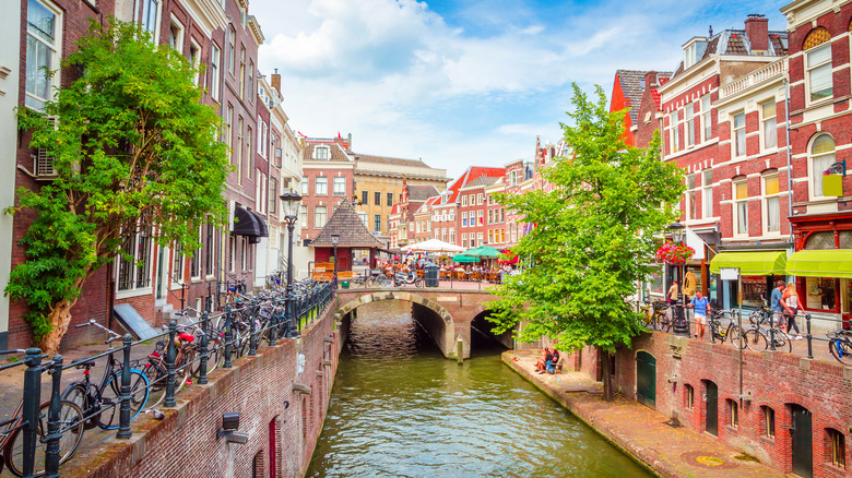
Utrecht, a beautiful medieval city in the Netherlands, was once known for its canals. That is, until the city drained the canal and turned it into a highway in the 1970s. This was never a popular decision, but it took years before the canals were finally fully reopened in 2020, to the joy of the citizens.
Utrecht, the Netherlands' lesser-known and just-as-pretty canal city, is thriving, and a lot of that is thanks to its idyllic, well-preserved historic center. But in the late 1970s, Utrecht's city planners decided to remove the 900-year-old canal, once a moat, and turn it into a ring road around the city. This idea was so heavily opposed from the start that the city compromised and only drained half of the canal. Calls for removal were immediate, and the rest of the loop was never completed. In 2002, the city voted to fully restore this waterway, with the first section reopening in 2015. The restoration was officially completed in 2020.
Locals celebrated, including those who had opposed the original idea of draining the canal way back in the 1960s. Reopening was a triumph, and even as Utrecht continues to reap the rewards, it also serves as a cautionary tale for developing cities to build for the people, not for the cars.
San Francisco
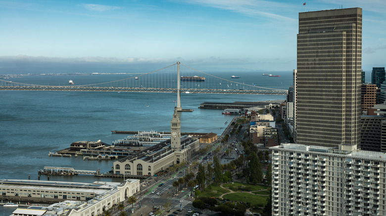
San Francisco's Embarcadero Freeway was an eyesore for many years, blocking much of San Francisco's famous bay from the rest of the city, until the 1989 Loma Prieta Earthquake, which also caused heavy destruction in Oakland, damaged it severely. This forced city officials to consider other options after years of debating, and the freeway was removed to make way for more waterfront access along with a new promenade and plaza.
Next City, a nonprofit news organization dedicated to urban policy, reported that housing in the area that was once overshadowed by the Embarcadero Freeway has grown by over 50%, while jobs have grown by nearly 25%, and that former neighborhoods isolated or cut off from the rest of the city have experienced a resurgence. Even the city's iconic Ferry Building has been revitalized with a farmer's market and shops.
The success of the Embarcadero Freeway removal has inspired other cities around the world to embark on similar projects, as it provided tangible evidence of the success of such an endeavor. Today, similar initiatives continue in San Francisco itself, as well. In 2025, a section of beach that was formerly blocked by the Upper Great Highway became a car-free coastal park with oceanfront charm.
Seattle
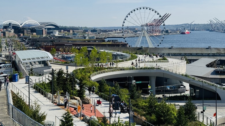
Seattle is another city that lost a valuable piece of its waterfront to a freeway, specifically the Alaskan Way Viaduct. In 2024, Seattle completed a massive urban renewal project to reroute the Alaskan Way into tunnels. Thus, the whole neighborhood has been revitalized as a walkable, vibrant haven with a cool waterfront park. Like San Francisco and Oakland, the viaduct had been damaged in an earthquake in 2001 and no longer met seismic standards. The city decided to reroute cars into a tunnel since the highway was notorious for noise and debris, as well as blocking views and sunlight — ever important in rainy Seattle. In addition to the tunnels, the city added two new connecting boulevards (a new Alaskan Way and Elliott Way) at street level, a new promenade, a two-way bike path, along with widened sidewalks, more street crossings, over 500 trees, on-site stormwater management, and increased lighting.
The waterfront project on the site of the former Alaskan Way Viaduct continues to evolve. In 2024, Overlook Walk, a pedestrian bridge above the new Alaskan Way, was completed. Overlook Walk isn't just a chunk of concrete, however; it provides incredible views of the surrounding area, along with concession stands and a playground. It also features a natural pathway that mimics the changes of Washington's endemic plants across elevations. The Salish Steps, honoring the Coast Salish people who have inhabited Seattle for time immemorial, will open by the end of 2025.
Madrid
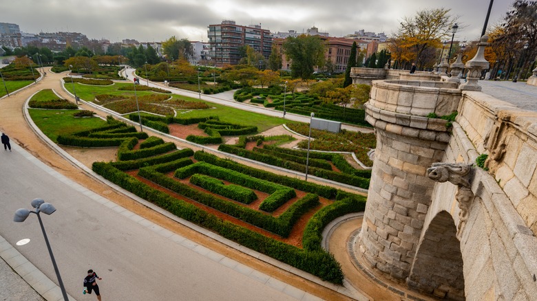
In Madrid, Spain, the once vibrant banks of the Manzanares River were overtaken by a congested freeway. That is, until 2011, when the roads were diverted into tunnels, and the riverbank once again was filled with parks, bike lanes, and trails.
In the 1970s, a ring road was built along both sides of the Manzanares River in central Madrid, effectively ripping a hole through the city's neighborhoods, causing decline on both sides. Still, when the revitalization of the riverfront and demolition of the freeway were proposed, along with a larger plan to broaden the public transportation of the city to reach neglected areas on the outskirts of Madrid, many were skeptical of what seemed an impossible task.
And yet, in 2011, after four years of construction, the underground tunnels were complete and the new 6-mile-long, 300-acre park, Madrid Río, opened. Neighborhoods forced apart are connected, and residents who live near the park are becoming healthier, with access to its trails, community centers, a beach, and a multitude of playgrounds. One lifelong resident of the area told the New York Times, "This is like new lungs for us," proving that the mistakes of the past can be corrected to positive results.
Methodology
For this article covering successful freeway removal projects and their corresponding cities, we researched sources from a variety of experts, like the Congress for the New Urbanism, the main driver behind the H2B movement, as well as the Urban Land Institute, various urban planning nonprofits, research entities, governmental reports, and more.
We've included cities both within and outside the United States to showcase the universal success and challenges of this movement. Many of these projects are ongoing, and their full impact on communities is not yet known, so we've endeavored to include projects that are considered completed.