5 Phoenix Hikes That Are At Their Most Stunning Right After An Arizona Rainstorm

As Arizona's capital and largest city, Phoenix offers most of the state's urban destinations and amenities, giving travelers a bit of a break from the wild desert landscape on all sides. Plus, as the fifth-largest city in the United States, Phoenix has urban amenities for virtually every type of visitor, from luxury hotels to historic and walkable suburbs like the neighborhood of Garfield. Still, Phoenix is very much a part of Southern Arizona's epic Sonoran Desert, a geographical quirk that gives the city a much greater offering of breathtaking outdoor hikes and scenic trails than many peer cities. The area in and around Phoenix is rich in some of the country's most unique hiking trails, all stretching through one-of-a-kind desert landscapes, rugged mountain peaks, and veritable forests of the state's iconic Saguaro cacti. And, of course, such hikes give you a taste of Arizona's formidable desert climate.
Being part of the Sonoran Desert means that Phoenix's hiking trails tend to be both hot and dry. Summers in Phoenix are unsurprisingly sweltering, while winter temperatures remain in the "pleasant" range. More importantly, the Phoenix area gets noticeably little rainfall, averaging a mere 7.22 inches of rain each year. However, while precipitation is rare here, "rare" does not mean "non-existent," and Phoenix-area trails do get some fairly significant rainstorms from time to time (particularly during the region's infamous monsoon season). And while rain is normally a detriment to an outdoor hike, rainfall in the Phoenix deserts brings about a particular type of magic that's worth experiencing. With everything from ephemeral waterfalls to blooms of color (and even a distinctive, pleasing aroma), these five hikes in and around Phoenix are the best to experience after an Arizona rainstorm.
Holbert Trail to Dobbins Lookout, South Mountain Park and Preserve
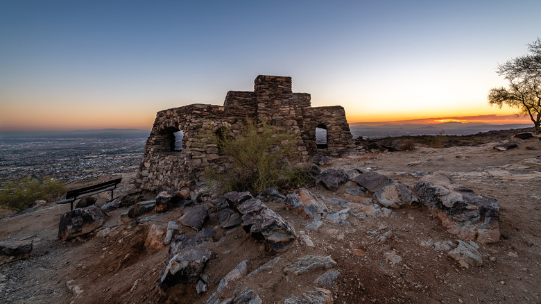
With more than 16,000 acres, Phoenix's South Mountain Park and Preserve is the largest municipal park in the United States, and the fourth-largest park located within an American city. Though it's just a few miles from Downtown Phoenix, South Mountain Park and Preserve contains three different mountain ranges: the Gila, the Guadalupe, and the Ma Ha Tauk Mountains. All of the park's impressive peaks intersect with the complex biodiversity of the Sonoran Desert, creating a peculiar type of beauty you won't find anywhere else. And as it's technically an urban park, South Mountain Park and Preserve also provides extraordinary scenic vistas of the Phoenix skyline alongside its majestic desert views.
If you're lucky enough to visit South Mountain after a rare Arizona rainstorm, you'll be treated to the additional magic of ephemeral streams and cascades flowing through the park's many washes, heavenly views of Phoenix framed by the Arizona sun breaking through rain clouds, and the unmistakable scent of mesquite and creosote unlocked into the air by the rain.
Virtually any of South Mountain Park and Preserve's abundant trails provide excellent immersion into the park's post-rain wonders. However, if you're looking for the best combination of manageable hiking challenges, South Mountain attractions, and exceptional post-rain views, the magnificent Holbert Trail is probably your best bet. Beginning from the parking area near the park's main entrance, the Holbert Trail stretches about five miles up the side of South Mountain. During the route, hikers will pass by a diverse display of desert flora, scenic viewpoints, ancient rock art, and deep canyons, many of which fill with picturesque streams after a rainstorm. The Holbert Trail culminates at the park's unforgettable Dobbins Lookout. Not only is Dobbins Lookout one of Arizona's best sunset-viewing spots, but its panoramic views provide unsurpassed shots of the Phoenix landscape decorated in post-rain greens and retreating clouds.
The Freedom Trail, Phoenix Mountains Preserve
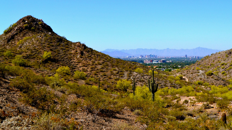
A more challenging, but no less stunning, mountain hike within the Phoenix city limits is the exhilarating Freedom Trail through Phoenix Mountains Preserve. Though it sits a mere 20 minutes from Downtown Phoenix, the Phoenix Mountains Preserve looks as remote and majestic as the most isolated desert wilderness. The park, true to its name, protects some of the most stunning mountains within Phoenix, including the 2,605-foot Piestewa Peak and the 2,706-foot Camelback Mountain. The jagged rocks of the mountains contrast with a rich tapestry of eye-catching balancing rocks and Sonoran Desert flora, including plenty of iconic saguaro cacti.
Phoenix Mountains Preserve has a sizable network of trails for hiking, mountain biking, and horseback riding. Any of these trails will provide a memorable tour of the park's vibrant landscape; however, the Freedom Trail is arguably the park's best bet for adventurous challenges, comprehensive sightseeing, and spectacular views. The basic Freedom Trail route circumnavigates the base of Piestewa Peak, covering around 3.8 miles and an elevation gain of around 1,000 feet. The main circular trail provides no shortage of photo-worthy views of the mountains and the Phoenix skyline. However, if you're feeling particularly adventurous, the Freedom Trail also connects to the Piestewa Peak Summit Trail, where you can find perhaps the best panoramic views of Phoenix and the surrounding landscape. Even better, there's no entrance fee!
After a rainstorm, spots of color will begin dotting the mountain terrain around the Freedom Trail. With such dry conditions in Phoenix, desert plants take advantage of any precipitation to erupt in full bloom. Those that unfurl their petals a few days after it rains include the pincushion cactus, which has bright pink flowers, and the yellow desert marigold, desert senna, and Coulter hibiscus. To see even more wildflowers, be sure to visit in the spring.
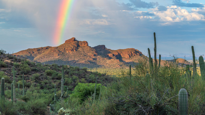
Jacob's Crosscut and Siphon Draw Trail, Lost Dutchman State Park
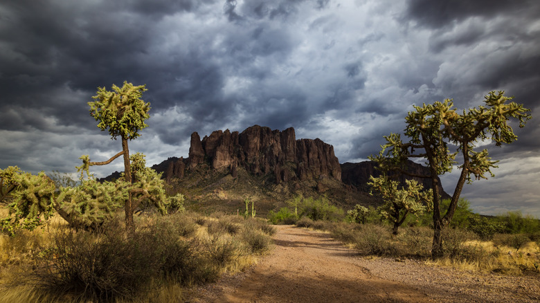
Sitting just 40-50 minutes from Downtown Phoenix, Lost Dutchman State Park has been ranked the top state park in Arizona by AllTrails users. Taking its name from a legendary "Lost Dutchman Gold Mine," Lost Dutchman State Park is a vibrant Phoenix-area paradise for hikers and campers alike. The park's magic comes from the appropriately-named Superstition Mountains, a complex of well-weathered volcanic rocks sculpted by millions of years of erosion into a fearsome display of jagged peaks. With a healthy covering of cacti, creosote, and desert trees, Lost Dutchman State Park is a dream-like combination of a classic western and a fantasy movie.
Like other Sonoran Desert parks, Lost Dutchman State Park is a great place to keep an eye out for blossoming plants after a rare Arizona rainstorm. When this happens, the Jacob's Crosscut and Siphon Draw Trail is perhaps the best route for exploring this one-of-a-kind setting without too many challenges. Despite the park's somewhat intimidating terrain, the Jacob's Crosscut and Siphon Draw route is a relatively easy hike, covering about two miles in a fairly flat loop around the Superstition Mountains.
With flatter terrain, the trail provides an excellent view of the towering Superstition Mountains framed by parting storm clouds. You can also hike part of the four-mile Siphon Draw route, which takes you to the namesake canyon that often features lovely ephemeral streams and cascades after a rainstorm. The park sees higher precipitation during the cooler winter months, which is good, as the Siphon Draw Trail has limited shade and often gets dangerously hot in the summer. Also, keep in mind that rain will make the rocks slick, so exercise caution and admire any water rushing down the trail from a safe distance, stopping your ascent when you encounter it. Note that entry into Lost Dutchman State Park costs $10 per vehicle ($20 for parties of two to four people), or $5 for individuals or bicyclists.
Hieroglyphic Trail to Petroglyphs, Superstition Wilderness
If you're craving a more rugged adventure through Phoenix's stunning Superstition Mountains than even Lost Dutchman State Park can provide, consider a trek through the Hieroglyphic Trail in the neighboring Superstition Wilderness. As a designated wilderness area within the epic Tonto National Forest, the Superstition Wilderness protects the most pristine display of desert and mountain that you can find within the Phoenix Metropolitan Area. In contrast to Lost Dutchman State Park, access to the Superstition Wilderness is free. However, note that, as a wilderness area, the trails in the Superstition Wilderness tend to be less developed and less well-marked than those in Arizona state parks like Lost Dutchman. Still, hiking routes like the Hieroglyphic Trail are certainly manageable for the average hiker, especially during cooler, post-rain periods.
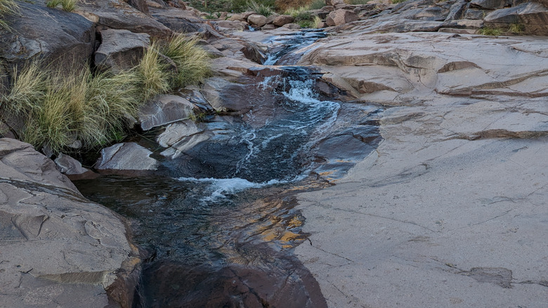
The Hieroglyphic Trail covers about three miles through the striking Hieroglyphic Canyon. While the terrain is rocky (and can be slippery after a rainstorm), the trail's total elevation gain is only around 570 feet, so hikers won't have to worry about attempting any steep cliffs or perilous summits. The trail's route also covers some of the most scintillating post-rain landscapes within the Superstition Mountains, complete with surprisingly lush forests of sycamores, cottonwood, and juniper trees that reach their full "lush-ness" after a rainstorm.
Arizona rains also bring gem-like pools and ephemeral waterfalls to the trail's Hieroglyphic Canyon, creating the rare sight of desert terrain juxtaposed with cascading water. Once you've traversed the heavenly rainy landscape of the Superstition Mountains, you'll be rewarded with the cultural treasures that give the Hieroglyphic Trail its name. The rock faces within Hieroglyphic Canyon feature several well-preserved examples of ancient rock art, likely created by the Hohokam people between 1,000 and 1,500 years ago.
Canyon of the Waterfalls Trail, Tonto National Forest
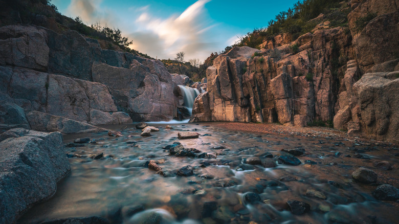
One of the main draws of a post-rain hike in the Phoenix area is the likely presence of numerous ephemeral waterfalls and streams, a rare sight in the generally arid Sonoran Desert. While you can generally find plenty of ephemeral waterfalls throughout southern Arizona after a rainstorm, a hiking route that's literally called the "Canyon of the Waterfalls Trail" is unlikely to be surpassed when it comes to picturesque desert cascades.
The Canyon of the Waterfalls Trail is part of Arizona's phenomenal Tonto National Forest, a vast, 2.9-million-acre preserve of Arizona desert beauty just east of Phoenix. Though it contains some of the most rugged, mountainous terrain in the Sonoran Desert's Tonto Basin, Tonto National Forest also has a vibrant network of rivers and watersheds. Arizona's rainstorms transform Tonto National Forest into a palatial wonderland of waterfalls, most of which are viewable on the park's many excellent hiking trails.
Although its name suggests a prominent place in Tonto's network of waterfall hikes, the Canyon of the Waterfalls Trail is less of an "official" hiking route and more of an unofficial combination of different trails and scenic viewpoints. As such, the trail is less user-friendly than novice hikers would probably prefer, and anyone attempting it should have some good navigational skills and outdoor experience. If you're able and willing, however, the Canyon of the Waterfalls Trail covers nearly five miles of unforgettable Sonoran Desert scenery, complete with panoramic desert views and oases of desert flowers popping up in the rainy landscape. The trail's namesake canyon has the perfect topography for mesmerizing, multi-tiered waterfalls to materialize after it rains — though make sure you watch out for the slippery rocks on the way down!
Methodology
Precipitation and its effects on a landscape are always complex and unpredictable variables, especially in an ecosystem as fickle as the Sonoran Desert. Therefore, compiling an "objective" list of the best post-rain hikes in the Phoenix area is borderline impossible. In creating this list, we therefore looked at a combination of objective trail measurements and difficulty levels with more subjective reviews from hikers and photographers who have experienced Phoenix-area rains firsthand.
We first focused on prominent trails that are either within the Phoenix city limits or within an hour's drive of Downtown Phoenix. Each of these trails has notably beautiful scenery, regardless of weather conditions, ensuring that hikers will get plenty of picturesque views on both rainy and sunny days. We also focused on trails that are only a few miles long, and which most hikers can complete within a few hours.
Finally, we had to grapple with the more complicated issue of what each trail is like after a rainstorm. Biologically, many of the Sonoran Desert's plant species have evolved to take full advantage of any precipitation, given the scarcity of water in the desert. The exact flowering conditions depend on an extremely complex web of factors, however, and there's never a guarantee that any one hike will feature extraordinary wildflower blooms after it rains. Still, many of the trails on this list are particularly acclaimed for beautiful wildflower views. Finally, we looked at conditions for ephemeral waterfalls and streams to form. While hydrological features also rely on complex factors, ephemeral waterways tend to follow natural paths (i.e., washes, canyons, gulches, etc.) after it rains. Each of these trails on this list passes by topographical features that often conduct drainage routes during rainstorms, creating ideal conditions for streams and waterfalls.