America's 5 States With The Most Islands
Search the United States Geological Survey (USGS) for islands in the U.S. and you get 17,358 listings. But they're not shared equally across the country. There are some states that lay claim to thousands upon thousands of islets, while others have just a trickle, or indeed none at all.
This guide is all about pinpointing the places that are very much blessed on the islands front. Using data from the USGS, it homes in on a handful of states that count the highest total number of isles. The result is a pretty tempting array of places for the ocean-loving, beach-obsessed traveler, since it hops from some of the most astounding corners of the East Coast all the way to the Arctic, and even dips into the tropical waters of the south.
You'll notice a common thread: all the states with high numbers of islands are coastal, with typically long shorelines that are broken up by bays, glaciers, fjords, coral reefs — you name it. New England and the Eastern Seaboard make a particularly strong showing, but the top spot is quite rightly reserved for the wildest state of all.
Alaska
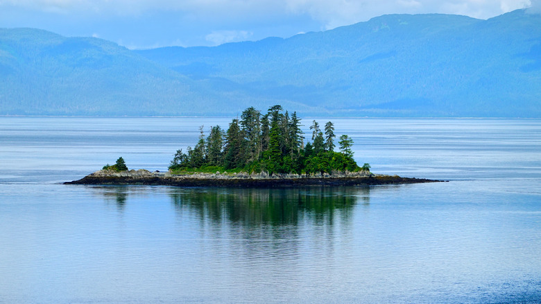
It shouldn't come as too much of a surprise that it's the seemingly endless landscapes of Alaska that come up trumps here. This state is, simply put, massive. Check the statistics: It encompasses a mega 365 million acres, is 2,400 miles wide, and has feet in both the Arctic Ocean and the Pacific Ocean. All that, plus it's one of the most undeveloped corners of the USA, so nature still reigns supreme — you've got over 57 million acres of dedicated wilderness in The Last Frontier!
That's the setting for a whopping 2,728 islands, according to numbers from the USGS. They're all over. You'll find them dotting the icy waters of the Glacier Bay National Park in the form of the Beardslee archipelago, kayaking meccas one and all. You'll get them seal-speckled and rich in marine life at the Inian Islands, which sit right where the cold currents of the Gulf of Alaska meet the Inside Passage.
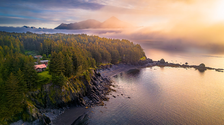
But no mention of Alaksa's great isles could possibly be complete without a nod to Kodiak Island. The second-largest island in the whole of the United States sits roughly 30 miles off the mainland, rising in a symphony of forest-clad mountain peaks that go more than 5,000 feet up from the ocean. The rock is dominated by the Kodiak National Wildlife Refuge, a 2-million acre park that's roamed by the rare Kodiak brown bear, who survive on the rich salmon runs of the native riverways.
Maine
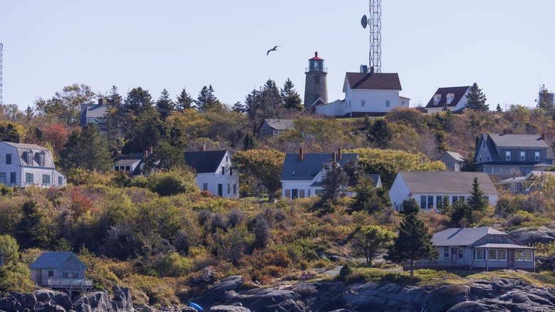
Maine's nickname, the Pine Tree State, hardly tells the full story. Yes, this is America's most forested state relative to its size, but it also flaunts 3,500 miles of coastline that ranges across inlets, bays, beaches, lighthouse-capped capes, and — of course — islands. In fact, according to the USGS, Maine is second only to Alaska when it comes to the sheer number of islands, totting up a seadog-inspiring 1,906 in total.
The largest of the lot? That honor goes to Mount Desert Island. It's actually famed all over as the home of Acadia National Park, which is considered to be one of the coastal gems of New England as a whole. The salty town of Bar Harbor clings to its northeastern shoreline. Base yourself there for whale watching tours during the summer months, or for scenic drives along Park Loop Road, a 27-miler that includes glacier-carved mountains, hemlock forests, and photogenic beaches.
Beyond that are countless other quintessential Maine islands that are great for summer getaways on the East Coast. For example, one-square-mile Monhegan Island is a real escape set 10 miles out into the Atlantic Ocean, where lobster fishing shacks and old painting workshops sit side by side. Meanwhile, little Peaks Island is a 20 minutes' ferry ride from the bustling city of Portland, offering a antidote to urban life in the form of community eateries and sandy beachfronts.
Florida
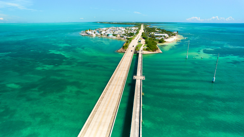
Welcome to the southernmost of the Lower 48 states, where there's over 2,900 hours of sunshine every year, and more idyllic beaches than you can shake a ticket to Walt Disney World at. Yep, Florida is America's flattest state and home to the some of the country's most iconic tourist destinations. It's also got the third-highest number of islands overall — 1,741 in total, according to the United States Geological Survey.
Perhaps the most famous chain of islets here is the Florida Keys, a tiara of over 110 dots on the map that curve for 220 miles into the sea. They're vacation havens from tip to toe, touting coral reef reserves filled with sea sponges and angelfish alongside the buzzy nightlife hub of Key West, a onetime haunt of Ernest Hemingway, no less.
Out west, Anna Maria Island arcs for seven miles beside the Gulf Coast. It's a gorgeous number, with powdery quartz beaches that are soft as soft can be fringing its whole length. Out east, where the Sunshine State meets the big Atlantic blue, you'll find the scenic trails and lagoons of America's first national wildlife refuge on Pelican Island. And then there's the so-called Ten Thousand Islands that pepper the ends of the Everglades. There aren't quite as many as the name implies (otherwise Florida would be top of this list!), but they are a wonderful showcasing of mangroves and fish-filled waterways.
New York
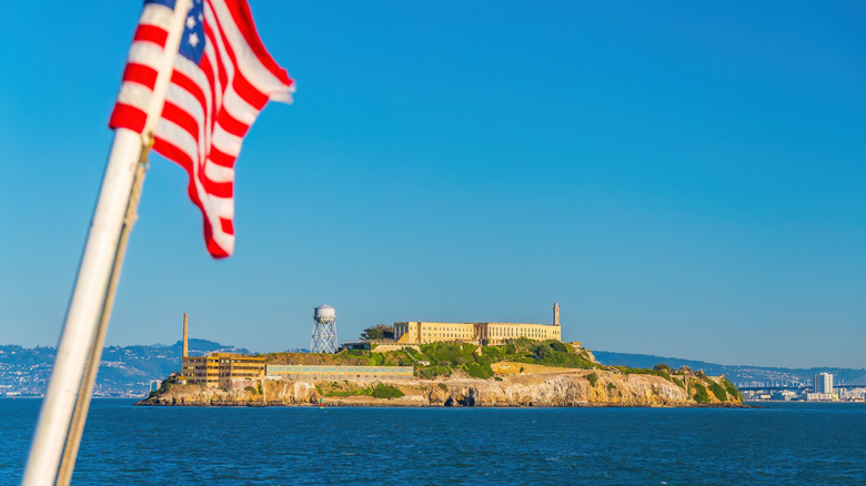
Over in the Empire State, you'll encounter some of the best-known islands in the country without even leaving sprawling New York City. Take the small rock of Liberty Island, crowning the Upper Bay with the unforgettable outline of the Statue of Liberty. Even bustling, skyscraper-capped Manhattan – home of Broadway and Central Park, with a population of nearly 1.6 million — is an island. Thing is, they are but two in a total of 885 islands that pepper the state.
Yep, this corner of the northeast has plenty of water-ringed rocks to explore. Head away from said sprawling metropolis and you can find some real gems. Assemble Great Gatsby buffs for Long Island, a 118-mile finger that protrudes into the Atlantic in a show of some of the most opulent mansions in America. Get to the very end to discover Montauk, one of New York's most famed beach towns, where surf and seafood eateries abound.
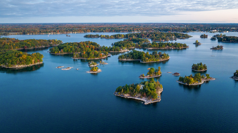
One huge chunk of New York's total island count is surely down to the region known as the Thousand Islands. There are actually closer to 2,000 islands there, but they're shared with the Canadian province of Ontario, spilling across the border over the St. Lawrence Seaway. According to VisittheUSA.com, visitors should begin adventures in those parts with a boat trip, to learn the swashbuckling pirate history and see some of the handsome castles that pepper the banks.
Massachusetts
It's another Eastern Seaboard state that finishes off this list of the U.S. territories with the most overall islands. Cue Massachusetts, where the United States Geological Survey reports there are upwards of 660 separate islands in all. The high number is largely down to the geography of MA: rocks and islets fragment off of a coastline that twists and turns and bends and opens into wide bays, clocking up a colossal 1,500 miles of shore in all.
Among them are some seriously well-known names, not least of all Martha's Vineyard, an iconic American island that has all the charm of an English village. Shaped like a triangle and rising up from the Atlantic some 4 miles from the mainland, it's long been a vacation spot of choice for presidents. But you don't have to hold high office to string together an itinerary like the one recommended by the New York Times — one that's packed with lobster rolls and sojourns on the Vineyard's glorious sandy beaches.
Just 15 miles across the ocean from there is another MA island that ranks highly for travelers: Nantucket. It has a healthy rivalry with Martha's Vineyard, and there are hot debates about which is better. According to one past visitor writing on Reddit, it's "Nantucket hands down! It's gorgeous and very easy to navigate on bikes. Yes, it's one town but with a lot of restaurants and shops. It's perfect for a weekend." What's more, according to Lonely Planet, the beaches of Nantucket are more accessible, since they are all open to the public.
Methodology
To pinpoint the states that count the most islands of all, we looked to the United States Geological Survey's Geographic Names Information System (GNIS). It's essentially a database of geographical features across the U.S., listing everything from mountain ranges to forests, and beaches to bays. We searched the GNIS for any feature classed as an "island," which is defined by the USGS as an "area of dry or relatively dry land surrounded by water or low wetland (archipelago, atoll, cay, hammock, hummock, isla, isle, key, moku, rock)." We then analyzed the data to count how many individual occurrences of islands there were in each state, listing the five with the most above.