Ohio's 5 Best Hiking Trails In And Around Columbus For A Scenic Outdoor Escape
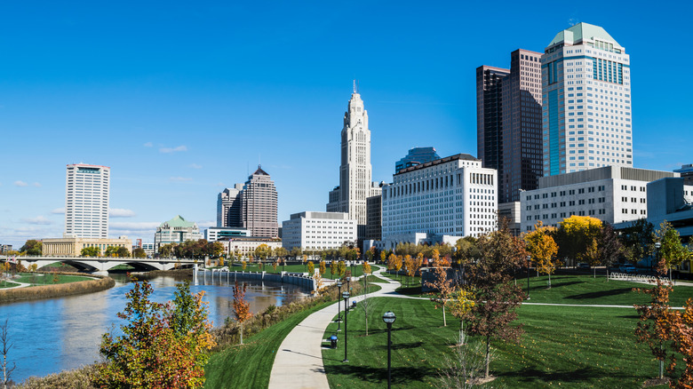
Columbus is both the capital of Ohio and the state's largest city. However, in contrast to other Ohio metro areas like Cleveland and Cincinnati, Columbus' media and stakeholders have often noted that the city lacks a coherent identity as a cultural, recreational, or historical destination. Of course, cursory glances can be deceiving. Columbus is actually rich in excellent urban hiking and walking routes, enough to get it ranked as one of the top walkable cities in the United States. Anyone looking for a long walk through an underrated area can explore any one of the city's many superb hiking routes, like the one through Westerville (a scenic Columbus suburb with charming boutiques and a pretty trail system) or along a Columbus trail that connects craft distilleries.
Even more remarkable than these urban haunts, however, is Columbus' equally rich collection of green spaces. All across the metro area, you can find numerous parks, greenways, and wooded areas that will transport you from the big city to pristine wilderness in mere minutes. Despite its aforementioned reputational challenges as a prime tourist destination, Columbus enjoys surprisingly lush nature preserves with forests, creeks, and even waterfalls. Most of these parks and green spaces protect segments of Columbus's roughly 230 miles of trails.
While sightseers can discover dozens of excellent outdoor experiences in the region, five specific spots stand out. These trails have vibrant scenery, quality infrastructure, and overall appeal. If you're traveling to Ohio, consider visiting these scenic escapes, which rank among the best hiking trails in and around Columbus.
Blendon Woods Loop
The Blendon Woods Loop is an easy yet lovely walk through one of the Columbus area's most beautiful urban woodlands. Find it within Blendon Woods Metro Park, a lush forest preserve protecting a haven of ravines, sandstone rock formations, and forests of beech, maple, and oak trees in Westerville. Spanning 653 acres, the park is small enough to provide an intimate urban hiking experience but large enough to host a thriving community of songbirds, waterfowl, and other photogenic wildlife.
For perhaps the best introduction to this ravishing park, explore Blendon Woods Loop. Roughly 2 miles long, the loop is manageable for most hikers, with well-maintained infrastructure and few if any strenuous sections. Most visitors complete the entire loop in around an hour, though Blendon Woods does often demand more time for birdwatching, photography, or just basking in the park's forested tranquility.
Blendon Woods Loop is actually a combination of several shorter hiking routes through Blendon Woods Metro Park. The full loop includes Blendon Woods' Brookside, Hickory Ridge, Ripple Rock, and Overlook trails. Each route showcases a different area of the park, allowing the complete trail to immerse hikers in Blendon Woods and its many woodland marvels. The most common course along the loop begins at the Overlook Trailhead parking area, near the park's ranger station. Once you finish your trek, you can also stop by the Blendon Woods Nature Center for some informative displays and wildlife viewing (and maybe some hot chocolate, too).
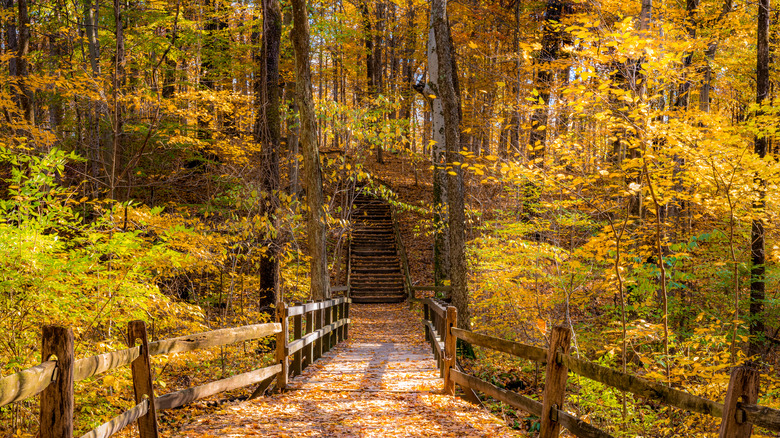
Millikin Falls via Connector, Boardwalk, and Flat Rock Loop
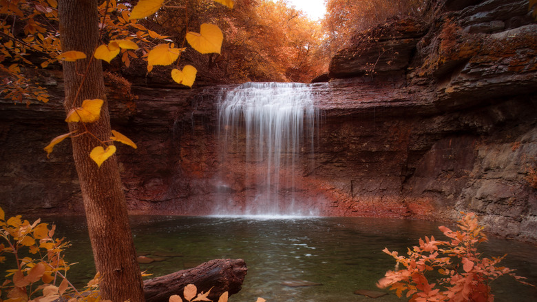
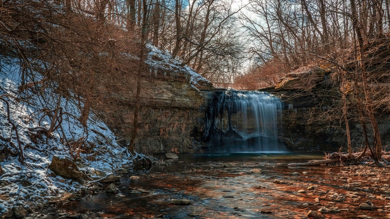
Few natural features are as sought after by hikers as an epic waterfall. Central Ohio, however, is rarely associated with such features, to say nothing of a heavily developed urban area like Columbus. This is why the trail to Millikin Falls is such a treasure. In a mere 1.6 miles, hikers can visit a waterfall gem while exploring one of Columbus' prettiest metro parks.
Even without a water feature, Quarry Trails Metro Park would be a remarkable destination for its ingenious design alone. Per its name, the destination lies atop an abandoned stone quarry outside Columbus. Rather than leaving the discarded quarry to fester as an eyesore, local officials instead repurposed it into a delightful preserve of salvaged forests, scenic trails, and Ohio's first via ferrata climbing routes on the site's solid limestone walls.
The park's past quarrying projects also led to the creation of Millikin Falls via the diversion of water through an area called Roberts Millikin Ditch. Though the cascade's 25-foot height is relatively modest compared to some of the world's most famous and ethereal waterfalls, its dramatic framing within a limestone cliff surrounded by forest beauty makes it as Instagram-worthy as any. It also makes Millikin Falls one of the top hiking destinations around Columbus. The most common (and, arguably, best) route to Millikin Falls combines Quarry Trails Metro Park's Connector, Boardwalk, and Flat Rock trails for a scenic jaunt of less than 2 miles. This journey loops around the artificial lake in the remains of Marble Cliff Quarry. Eventually, hikers reach a convenient observation deck at Millikin Falls, where they have the option of getting even closer via steps carved directly into the park's natural limestone.
Olentangy Trail
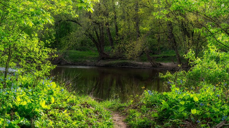
Olentangy Trail is one of the most beloved hiking routes in Columbus for good reason. Unlike the preceding trails on this list, Olentangy isn't confined to a single park. Rather, it follows the course of Ohio's gorgeous Olentangy River as it flows from Highbanks Metro Park near Worthington all the way to Downtown Columbus. Stretching 97 miles through central Ohio, this river serves as both an important water source and a way to highlight the region's lovely wetlands, forests, and natural areas. These surrounding environments (including shale banks that rise 110 feet above the river at some points) were enough to earn the Olentangy recognition as one of Ohio's official scenic rivers.
This waterway has amazing water trails perfect for paddling adventures, but if you want to stay dry, the Olentangy Trail provides the same scenery. The full route covers around 14 miles north of Columbus, though there are many access points along the way for those seeking short section hikes. Overall, the trail consists of a northern and a southern section, each with unique sights and a distinctive atmosphere. The southern section travels through many of Columbus' loveliest greenways (including the Ohio State University campus), while the northern portion hits several beautiful community parks. Both areas are great for hiking and cycling.
Despite its 14-mile length, the Olentangy Trail features flat terrain and well-paved paths that make the entire hike fairly easy, even for inexperienced hikers. If you're into birdwatching, you'll also appreciate how the route passes through some central Ohio birding hotspots.
Blacklick Creek Greenway Trail
The immersive Blacklick Creek Trail is a lengthy but peaceful walking corridor along a waterway of the same name. Both the trail and creek go through Blacklick Woods Metro Park, a superb 652-acre nature preserve of unspoiled prairies, wetlands, and groves of maple and beech tree woodlands. Established in 1948, Blacklick Woods is the oldest metro park in Columbus. Today, it offers an excellent blend of gorgeous natural scenery and modern recreational amenities. For example, right next to its picturesque woodland scenes sit not one but two terrific golf courses: the expertly-designed Championship Course (for serious golfers) and the accommodating Learners Course (for beginners to get into the swing of the game).
Hikers, of course, will likely care much more about Blacklick Creek Trail than any tee times. While the route centers around its eponymous park, the full 16-mile trek also extends into nearby areas like Columbus' Pickerington Ponds and JFK, Huber, Portman, Chatterton, and Three Creeks parks. Despite this length, the generally flat terrain and maintained infrastructure along the way mean a lack of any strenuous challenges or technical sections that may turn some hikers off.
After enjoying your hike and the surrounding woodlands, make a detour to the Blacklick Woods Nature Center or the 40-foot-high, ADA-accessible Canopy Walk. The park also hosts several children's playgrounds. If you're up for a longer adventure, you can expand the basic Blacklick Creek hike into a 25-mile voyage along Blacklick Creek Greenway Trail. Mostly flat and shaded, this excursion showcases even more of the area's rich greenery.
Alum Creek Trail
Much like the similarly-named Blacklick Creek route, Alum Creek Trail follows the course of another lovely local waterway. In this case, the hike travels a more dramatic course of nearly 60 miles through the fertile plains and steep shale cliffs of central Ohio. At one end, the creek flows from the popular and scenic Alum Creek Lake just north of Columbus.
Beginning east of downtown Columbus, Alum Creek Trail hits its northern terminus at Wolfe Park, a family-friendly community area situated along the banks of Alum Creek. From there, the trail travels about 25 miles south through several scenic parklands and vibrant neighborhoods. Perfect for both hikers and cyclists, the route mostly consists of flat, paved asphalt and concrete paths. While on the lengthier side, the trek earns an "easy" rating from AllTrails for its broadly accessible terrain and lack of any notable challenges. Additionally, the trail's abundant tree canopy allows it to moonlight as one of Columbus's top birdwatching spots.
After traveling nearly 25 miles south of Columbus, the Alum Creek Trail ends in the lush Three Creeks Metro Park. The creek itself also concludes its course at a scenic junction with Big Walnut and Blacklick creeks; these three waters give Three Creeks Metro Park its name. If you're somehow up for even more hiking after your 25-mile walk, Alum Creek Trail connects to Blacklick Creek Trail and other worthwhile Columbus routes such as Bluebell Trail and Big Walnut Trail.
Methodology
In gathering a comprehensive master list of top Columbus-area hikes, we looked at both officially-listed greenway trails maintained by Columbus and Franklin County Metro Parks and user reviews on AllTrails. The latter showed which local trails ranked highest in terms of hiker satisfaction. Given that most of these routes are located in (or at least pass through) the region's many excellent metro parks, the greenways list provided useful information about each trail's features.
One issue we ran into, however, was the occasional discrepancy between highly-ranked hikes on AllTrails and listings from Columbus and Franklin County Metro Parks. For example, the trail to Quarry Trails Metro Park's Millikin Falls (extremely well-rated on AllTrails) is not a single path recognized by the Metro Parks Authority. Rather, it's a combination of several different routes. We ultimately decided to include this trek, as its component trails are official metro park routes. Plus, the hike's popularity on AllTrails shows that it's well-known and frequently traveled by locals.
Finally, we tried to avoid including overlapping trails. For example, Alltrails ranks Blendon Woods' Sugarbrush Trail as one of the top trails in the Columbus area. However, Sugarbrush significantly overlaps with Blendon Woods Loop, so we left it off this list of Ohio's five best hiking trails in and around Columbus.