5 Abandoned National Parks And Monuments That No Longer Exist
The 63 national parks and over 100 national monuments of the United States are all magnificent natural wonders or essential historic sites. Within that framework, though, they represent a surprising range of diversity. Some national parks have beginner-friendly trails for novice hikers, while others preserve remote wilderness available only to the most experienced backpackers. However, no matter their accessibility or challenges, most American national parks seem timeless, like spectacular monuments forged by nature and history that are as constant as the planet itself. If you've been awestruck at the dramatic vistas of the Grand Canyon or the divine contours of Yosemite Valley, you may be surprised to find out that some of America's once-prominent national park sites were straight-up abandoned.
The idea of a "defunct" national park seems both tragic and comical. After all, if a natural or historical treasure is important enough to earn coveted national park status, how could the government abandon it so cavalierly? Or, even worse, if the park's main resources were destroyed or tarnished, how could the country let that happen? The answers to these questions tend to vary, though politics, public interest, and (yes) money usually play a role in a park's demise.
The good news, however, is that many of America's "lost" national parks do still exist in one form or another, often under another form of protection in the National Park Service or another federal or state agency. Some of them are still prime tourist destinations today, despite losing their status. Though they no longer exist, these five former national parks and national monuments remain remarkable American treasures, and help tell the long and complex story of public land preservation in the United States.
Platt National Park
Though it's fairly well-represented within the National Park Service, Oklahoma does not currently have any national parks. That wasn't always the case, however. From 1906 to 1976, south-central Oklahoma was home to one Platt National Park, which, at its height, served as one of the nation's top destinations for outdoor recreation.
Similar to Arkansas's Hot Springs National Park (which is one of America's most unique), Platt National Park preserved a group of natural mineral springs for both sightseeing and a kind of natural spa experience. The 33 mineral springs of Platt National Park sit in an underrated region of Oklahoma between the Arbuckle Mountains and the Washita River Valley, near the contemporary Oklahoma town of Sulphur. In 1902, the federal government purchased the land from the Chickasaw and Choctaw nations to create a publicly-accessible preserve. In 1906, that preserve officially became Platt National Park, in honor of Connecticut Senator Orville H. Platt who had played a major role in the park's establishment.
Though Platt National Park was more of a small recreational area (complete with a golf course and animal pens) than the breathtaking panorama you'd expect in parks like Yellowstone or the Grand Canyon, it was extremely popular during its early years, even welcoming more visitors than Yellowstone and Yosemite in 1914! However, as the National Park Service grew in the ensuing decades, more and more travelers came to expect dramatic, monumental views from their national parks, rather than a small collection of lovely, but modest, mineral springs. In 1976, the increasingly-overshadowed Platt National Park was "demoted," or more accurately, combined with the nearby Arbuckle Recreation Area to create the new Chickasaw National Recreation Area. The good news is that Platt's freshwater springs and historic structures are still there, and still visitable (for free!), in Chickasaw National Recreation Area today.
Papago Saguaro National Monument
Few plant species are as closely associated with a particular state as the mighty saguaro cactus is with Arizona. The famed saguaro cactus obviously goes hand-in-hand with the destination that bears its name: the breathtaking (yet underrated) desert gem of Saguaro National Park. However, the saguaro cactus once lent its name to another Arizona NPS site, one that highlights both the aspirations and perils of the entire concept of a "national park." The former Papago Saguaro National Monument is notable for its exceptional ecological resources within the Phoenix metro area.
Though technically urban, this area held a gorgeous collection of red sandstone buttes and marvelous forests of saguaro cacti that, at the time, had significance for both scientists and tourists. President Woodrow Wilson officially designated the area as Papago Saguaro National Monument in 1914. Unfortunately, the establishment of a national monument on the site did not prove a cure-all for the ills that often afflict an urban park.
In contrast to other defunct national parks, which may have lost their status due to being too remote and too sparsely visited, Papago Saguaro National Monument suffered from a lack of federal funds. The park's initial 2,000 acres began to get chipped away for roads, railways, and powerlines. Shale mines depleted the park's famed rocks, and poachers straight up stole the park's namesake saguaros. In 1930, with the park torn from its initial purpose and suffering chronic underfunding, Congress made the then-unprecedented decision to de-list Papago Saguaro from the National Park Service entirely. The story has a semi-happy ending, however. Arizona reclaimed the land from the federal government and re-established it as Phoenix's Papago Park, a lovely (and better protected) municipal park with both natural beauty and family-friendly amenities.
Holy Cross National Monument
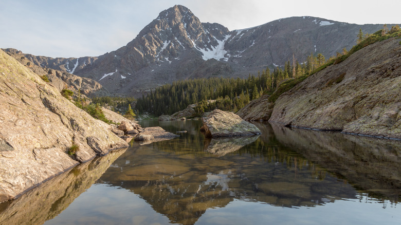
Among Colorado's many impressive 14ers (i.e., mountains that exceed 14,000 feet) sits a particularly storied peak known as the Mount of the Holy Cross. While the Mount of the Holy Cross is not the highest 14er in Colorado (at only 14,007 feet), it does have a fairly remarkable quality that once earned it the status of national monument.
The creation of Holy Cross National Monument can be traced back to a single photograph. In 1873, photographer William Henry Jackson joined a survey of Colorado's Sawatch Range, including a particular peak said to feature a large, distinctive cross when covered with sufficient snow. Jackson ended up being the first person to photograph this notable "snow cross" phenomenon, and the resulting photograph soon became a media sensation. Mount of the Holy Cross quickly became the site of religious pilgrimages. In 1929, President Herbert Hoover acceded to the mountain's increasing significance by establishing it as Holy Cross National Monument.
However, a national park still needs basic administration to operate. Unfortunately for Holy Cross National Monument, this proved to be a challenge almost immediately. Mount of the Holy Cross's remote mountain wilderness made it difficult for the National Park Service to house sufficient staff there. Add the minor fact that the federal government failed to provide adequate funding for administration, and Holy Cross National Monument quickly proved unviable. In 1950, just 17 years after its establishment, Congress officially abolished the national monument entirely. Today, Mount of the Holy Cross is part of the Holy Cross Wilderness in the U.S. Forest Service's White River National Forest. If conditions are right, and you're willing to make the challenging trek there, you can still see the mountain's famous snow cross in person.
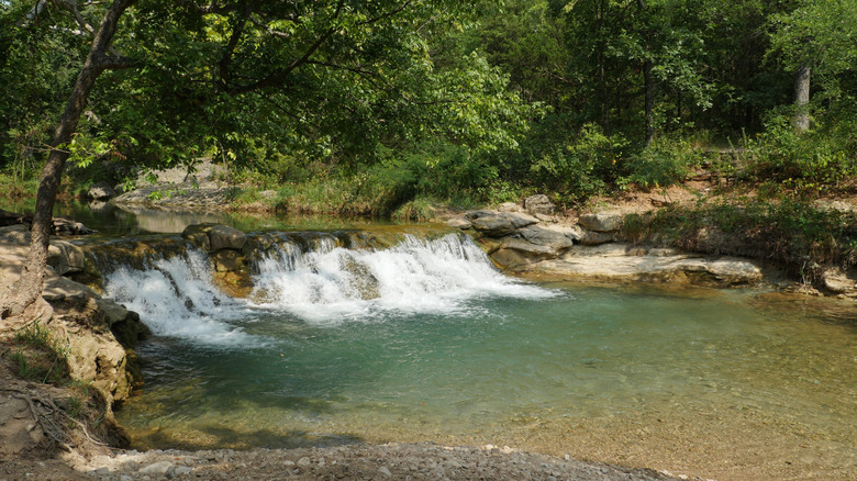
Lewis and Clark Cavern National Monument
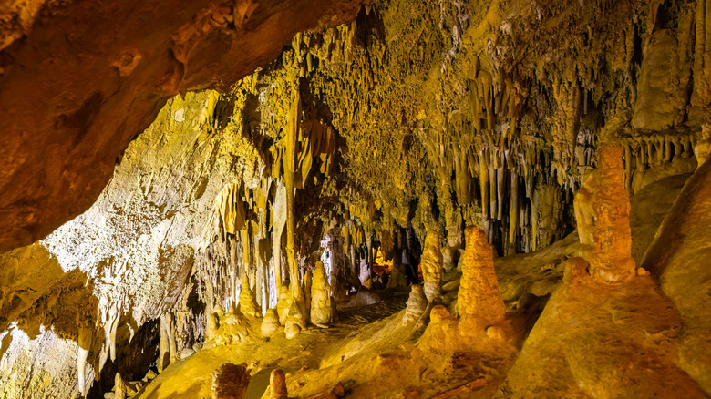
Lewis and Clark Caverns State Park is one of the preeminent wonders of the Montana state park system (and in a state as acclaimed for its aboveground scenery as Montana, that's really saying something). While Montana's Department of Fish, Wildlife, and Parks is more than happy to have it, Lewis and Clark Caverns was once considered a national monument.
The National Park Service is no stranger to amazing cave systems. With South Dakota's Wind Cave being one of America's oldest national parks and subterranean wonders like Mammoth Cave and Carlsbad Caverns breaking various records, national park caves can be just as spectacular as their surface-level brethren. Lewis and Clark Caverns more than lives up to this lofty national park standard, displaying intricate limestone formations and photogenic speleothems (i.e., cave formations) in one of the Northwest's largest cave systems. President Theodore Roosevelt agreed with the cave's many boosters, establishing the Lewis and Clark Cavern National Monument in 1908.
During its early years, the cave had limited accessible infrastructure, which, combined with its fairly remote location, made it quite difficult to access. In the 1930s, Civilian Conservation Corps workers constructed more developed infrastructure that made the cave easier and safer to visit. Still, Montana residents and politicians grew increasingly frustrated by consistently low visitation numbers and limited investment from the federal government. In 1935, Montana Governor Frank Cooney took the bold step of requesting that Congress officially transfer administration of the cave over to Montana. Congress agreed two years later, and in 1941, the Lewis and Clark Cavern National Monument opened as the Lewis and Clark Caverns State Park (Montana's first state park, in fact). With a 90-minute drive from Helena and an $8 entrance fee, you can explore this remarkable cave system today.
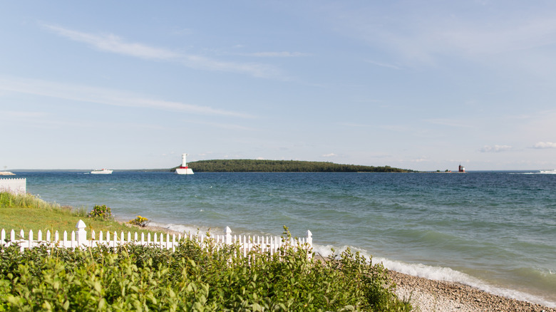
Mackinac National Park
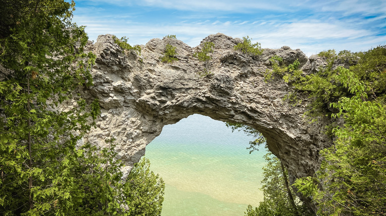
Today, Michigan's Mackinac Island is a major vacation and sightseeing option in the Upper Midwest, as the car-free island even boasts the timeless, elegant Grand Hotel resort. Lost in splendid lakeside views, historic small-town charm, and ample recreational opportunities is the oft-forgotten fact that this gorgeous Lake Huron island was once America's second national park. Strange as it sounds, Mackinac National Park was officially established by Congress in 1875, making it only three years younger than the much more famous Yellowstone National Park. This timing coincided with an overall shift in Mackinac Island's significance for the United States. Initially a strategic military base, the island became a major resort destination after the Civil War.
Increasing tourism brought the threat of overdevelopment, and local preservationists began to fear that the island's beloved features (like the 50-foot wide Arch Rock) would be destroyed. Fortunately, these preservationists had an ally in Congress, as Michigan Senator Thomas W. Ferry was a Mackinac Island native. Ferry built legislative support for federally protecting Mackinac Island, and Mackinac National Park was born.
However, national parks in the 19th century operated very differently than they do today, as the National Park Service was not established until 1916. Administration of Mackinac National Park largely fell to the War Department via the island's Fort Mackinac army base. This arrangement, however, did not account for the island's waning military significance. Fort Mackinac was decommissioned in the 1890s, and with it went the War Department's administration of the park. Congress, loath to spend additional funds on a new federal administration, agreed to turn Mackinac Island over to the state of Michigan in 1895. Michigan proved a better steward than the federal government, and Mackinac Island's state park and historic sites are popular attractions, accessible via local ferry services from Mackinaw City and St. Ignace on the mainland.