Arizona's 5 Best Beginner-Friendly Hiking Trails In Phoenix

Arizona's unforgettable desert scenery and rugged geography offer many of America's most formidable hiking challenges, including some within the Phoenix metro area itself. Just outside the state's capital and largest city, daring hikers can find worthwhile challenges like the breathtaking mountain escape of the Four Peaks Wilderness and the mythical "Lost Dutchman's Gold" at the intimidating Lost Dutchman's State Park. Of course, not every visitor to Phoenix is looking for a hiking challenge of those magnitudes. For many, a visit to Arizona's famed desert metropolis needs only a short and stress-free jaunt through some unique desert scenery.
Phoenix, being one of the largest cities in the United States, has a good share of municipal parks and urban walkways within its city limits. Most of Phoenix's local trails, including the easiest ones, showcase Arizona's distinctive desert flora and fauna (like Arizona's eminent saguaro cactus), as if hikers were trekking through the remote desert wilderness.
Different hikers with limited experience (especially in difficult climates than Arizona's) may have different criteria for what they're looking for in a "beginner-friendly" hike. Still, the broader hiking community often arrives at a somewhat satisfactory consensus on the relative challenge levels of each trail. For this list, we used the trail difficulty ratings on AllTrails.com as our main criteria for finding easy, beginner-friendly trails in Phoenix. Based on this methodology, these five Phoenix-area trails in particular are excellent routes for beginner hikers (or anyone looking for a more casual, relaxing stroll through Phoenix).
Double Butte Loop Trail, Papago Park

Papago Park's location, just a few miles from downtown Phoenix, belies its extraordinary desert ecosystem and geological formations, all of which would look more in place in a remote national park. In fact, the Papago Saguaro National Monument was once federally recognized, but it is, tragically, one of America's now-abandoned national parks that no longer exists. However, the National Park Service's loss was the city of Phoenix's gain, and today's Papago Park offers some of Phoenix's best urban hikes among truly magical desert scenery. Chief among these hikes is the unmissable Double Butte Loop Trail, the perfect journey through the park's incredible views in a short and easy hiking experience.
Described as a "beautiful trail" and a "nice easy walk" by AllTrails reviewers, the 4.6-out-of-5-starred Double Butte Loop Trail circles around the two prominent red buttes that serve as the epicenter of the park's scenery. Consisting of the same red sandstone you'll find in other prominent Arizona treasures like the Grand Canyon and the mesas around Sedona, the Papago Park's buttes form a colorful, eye-catching profile above the rich shades of the park's many saguaros, palm trees, and desert flowers. Despite the formidable natural features referenced in its name, the Double Butte Loop Trail covers a largely flat 2-mile route with minimal elevation gain. In other words, it's perfect for beginner hikers who want to ease themselves into Arizona's harsh desert landscape. Hikers on the Double Butte Loop Trail can also stop at one of the park's many ramada shelters for a lovely midday picnic, or just to enjoy the scenery of both the Phoenix skyline and the stunning Arizona mountains beyond.
Pima Wash Trail to West Loop, South Mountain Park
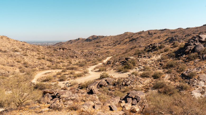
Phoenix's South Mountain Park and Preserve is one of the largest municipal parks in the United States, protecting a massive 16,000-acre preserve of the rugged-yet-beautiful Gila, Guadalupe, and Ma Ha Tauk ranges, which all converge in one magnificent display just outside downtown Phoenix. For novice hikers, or just anyone looking for a relaxing stroll through Phoenix's mega-park, the Pima Wash Trail to West Loop offers the best combination of low difficulty levels and abundant sightseeing opportunities. Of all the "easy" rated trails in South Mountain Park, the Pima Wash Trail to West Loop has the most consistently positive reviews on AllTrails, with reviewers describing it as a "great trail to run, mountain bike or walk," and a "lovely well marked and maintained trail." The trail is currently rated at 4.7 out of 5, with more than 6,000 AllTrails reviews.
Unlike the difficult, higher-elevation routes up the sides of the surrounding mountains, the Pima Wash Trail involves a mere 226 feet of elevation gain over 2.8 miles. Though visitors may encounter a few steeper sections, the trail overall is largely flat and accommodating for the average hiker. This lack of challenges does not correspond to a lack of scenery, though. Not only does the Pima Wash Trail showcase the park's stunning mountain peaks as they rise above the route's flatter areas, but it is rich in stunning desert flora (including some of Phoenix's best displays of wildflowers in the spring and summer). The trail also takes hikers past the ruins of an old stone house, which adds a haunting atmosphere to the trail's abundant desert beauty.
L.V. Yates to Charles Christiansen Trail, Phoenix Mountains Preserve
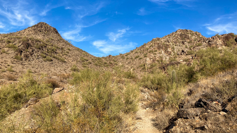
Much like South Mountain Park, the interconnected public parks that comprise the Phoenix Mountains Preserve showcase a stellar range of rugged desert mountains within the boundaries of the Phoenix Metropolitan Area. Phoenix Mountains Preserve's diverse park offerings range from the aforementioned Papago Park and its visitor-friendly amenities to the harsh summit routes of the 2,608-foot Piestewa Peak and the visitor-favorite (and free) Camelback Mountain. Hikers looking for easy, beginner-friendly routes can find a perfect Phoenix Mountains day-hike on the highly-ranked L.V. Yates to Charles Christiansen Trail. This 2.6-mile looping route draws together a few different established trails, with one AllTrails reviewer calling it "a nice easy hike with lots of cool [cacti] to see in the foreground of many mountains."
The main L.V. Yates Loop (i.e., Trail No. 8) follows a largely even path underneath the park's many mountains, with only a few uphill sections creating any challenges. Do note, however, that while the trail's terrain is mostly manageable for beginner hikers, it can be difficult to navigate, with a few potentially confusing junctions and turns. Even experienced hikers may want to bring navigation tools like GPS devices to avoid getting lost.
The Charles M. Christiansen Memorial Trail (i.e., Trail No. 100) is a much longer trail in total, measuring about 11 miles and including more moderately challenging (though not quite expert-level) terrain. The 2.6-mile L.V. Yates to Charles Christiansen loop combines many of the easier sections of both trails, while preserving the magnificent scenery of each. Hikers can bask at the sight of cactus-draped mountain peaks rising nearly 2,000 feet above the trail, while taking in superb views of the Sonoran Desert and the Phoenix skyline beyond the mountains.
Tempe Town Lake Trail

In a complete 180-degree turn from the previous entries, the Tempe Town Lake Trail is pure urban hiking bliss among Phoenix's metropolitan areas. In an oft-needed break from the mountainous desert terrain just outside of Phoenix, Tempe Town Lake is a lovely, family-friendly recreation center encircling a 2.5-mile artificial reservoir in the heart of downtown Tempe. The well-maintained concrete path that follows the lake's banks offers wonderful, stress-free walks along Arizona's hidden slice of urban beauty.
The full Tempe Town Lake Trail Loop is a bit longer than other easy Phoenix-area hikes, measuring over 7 miles in total. However, the trail is quite flat and even, and it is ADA accessible and has enough width to accommodate heavy foot traffic. Plus, the trail's many convenient junctions with nearby roads and neighborhoods let hikers limit their walk to shorter sections of the trail. AllTrails reviewers describe it as a "a very nice trail to ride during the day or night" and note that it "felt safe, maintained, and had great views of the river."
The highlight of the Tempe Town Lake hike (for infrastructure fans, at least) may be its crossing of the Tempe Town Lake Pedestrian Bridge. This attention-grabbing suspension bridge shines in a modern, intricate design that connects the lake's north and south shores (and even shines with blue lights at night). Awaiting on the south side of the bridge is the gorgeous Tempe Center for the Arts campus, a major Phoenix-area arts and entertainment center and the focal point of a popular 3.6-mile route within the Tempe Town Lake Trail.
Desert Botanical Garden Loop
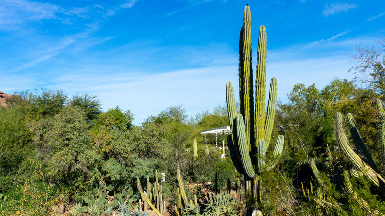
Phoenix's exceptional Desert Botanical Garden brings all of the iconic flora of Arizona's Sonoran Desert to a single lovely (and beginner-friendly) nature preserve. Contained within are five different themed trails circling through more than 50,000 Sonoran plants on display. While you can tour each trail individually, you can also explore all five trails in one immersive, yet easy, hike via the full Desert Botanical Garden Loop. Rated 4.7 out of 5 on AllTrails across more than 1,000 reviews, the Desert Botanical Garden Loop is a 2.1-mile walking tour that circles through the preserve's different thematic areas over much of the garden's 55 acres. Among all "easy" rated Phoenix trails, the Desert Botanical Garden Loop draws particularly rave reviews, with AllTrails users describing it as "a great place to just wander around" with "plenty of informational signs" on the area's remarkable botany.
During the full loop, visitors can explore the distinctive flora and fauna of the Sonoran Desert on the Desert Discovery and Sonoran Desert Nature Trails, stroll past gorgeous desert flower displays on the Harriet K. Maxwell Desert Wildflower Trail, learn about the people who have long made the Sonoran Desert their home on the Plants & People of the Sonoran Desert Trail, or get some practical tips for living among the desert today on the Center for Desert Living Trail.
As the Desert Botanical Garden is a cultivated nature preserve, the comprehensive route consists of flat, well-maintained paths. Each of the park's main trails is fully ADA accessible, making the full Desert Botanical Garden Loop the perfect destination for all hikers to experience the beauty of the Sonoran Desert. At the time of writing, General weekday admission for the Desert Botanical Garden is $32.95 for adults (if purchased online), or $34.95 (if purchased in-person), while weekend admission is $34.95 (online) and $39.95 (in-person).
Methodology

AllTrails currently features four different difficulty ratings for trails, ranging from "easy" to "strenuous." According to their own criteria, trails rated "easy" on AllTrails are "typically short, with clearly marked paths and fairly level terrain." Though difficulty levels are always going to be subjective, things like trail length, level terrain, and clear markings are objective enough qualities to reliably determine which trails are ideal for beginner hikers.
AllTrails helpfully ranks the trails in particular areas (like Phoenix), with the option to narrow the options down by difficulty level. The five trails that made our list are not only rated "easy" on AllTrails, but they also rank quite highly among all of Phoenix's easy hikes.
Rather than simply selecting the top five easy-rated Phoenix hikes on AllTrails, however, we made sure to include a diverse selection of different parks and hiking destinations. This allowed us to introduce beginner hikers to a wide range of Phoenix-area hiking destinations, including wild mountain parks like South Mountain and Phoenix Mountains, cultivated nature preserves like Desert Botanical Garden, and in-between destinations like Papago Park. While AllTrails was our main source, we supplemented our research with other popular hiking sites like 10adventures.com.