The All-Time Best Hikes In The Pacific Northwest, According To Travelers
Volcanoes, mountains, waterfalls, and endless stretches of open land — the Pacific Northwest (PNW) has a little bit of everything. The landscapes shift from rainforest to high alpine water, while centuries-old forests surround raging rivers that run cold and clear. It's a region that offers hikers year-round exploration, and there are trails to suit everyone. But it doesn't matter whether you're just starting or you're a seasoned backpacker; there always seems to be more to discover, no matter how many of them you tick off.
This list of classic PNW hikes is based on what hikers say in trail reviews, blog posts, trip reports, and forums where they describe what they saw and felt. They range from easy family-friendly loops to multi-day tests of endurance. Some push the mentality as well as the physicality, while others will have you finished and feeling satisfied before lunch. Most of the best hikes turned out to be in Washington, but we've included some from Oregon and Idaho, too.
However, they all have one thing in common — the people who do them tend to do them again. Some have left hikers struggling for words to describe what they saw because it can be difficult with such stunning views. The Pacific Northwest is untamed and beautiful, and it stays with you long after you leave. Here are some hikes that are often considered to be among the region's all-time best.
The Enchantments, Washington: A long but stunning hike
You cannot drive to the Enchantments in the Alpine Lakes Wilderness in Washington. You have to walk. On top of that, camping permits are awarded through a lottery and are difficult to procure. However, the effort is certainly well worth it, especially when Steph Abegg of the renowned alpine and adventure blog called it "easily one of the most beautiful places I've ever experienced on foot." It's Washington's "Crown Jewel of Hiking," and it's brimming with sapphire lakes and wild ridgelines.
The through hike covers about 18 miles one way, and it moves through three distinct zones. The Upper Enchantments are barren and almost lunar-like with their gray rock, loose scree, and patches of ice beneath the ridge of Dragontail Peak. Below there, the Middle Enchantments are home to some of the most dramatic lakes you'll see, and they are framed by smooth granite rock and centuries-old larches. The Lower Enchantments end at Lake Viviane, which is tucked into a deep granite bowl under Prusik Peak.
The place names tell you what the first visitors thought — Aasgard, Sprite, and Leprechaun certainly spark imaginations, but getting through them is another matter. Aasgard Pass gains 2,000 feet in just a mile and a half, with a scramble on all fours over boulders. The descent from Leprechaun Lake to Upper and Lower Snow Lakes isn't much easier with large boulder walls that are difficult to navigate, while the final stretch drags on a lot farther than most expect. One AllTrails reviewer summed it up when they said it's "about as hard as running a marathon." But they also said, "Surreal. Best hike of my life."
Timberline Trail, Oregon: A multi-day loop around an iconic peak
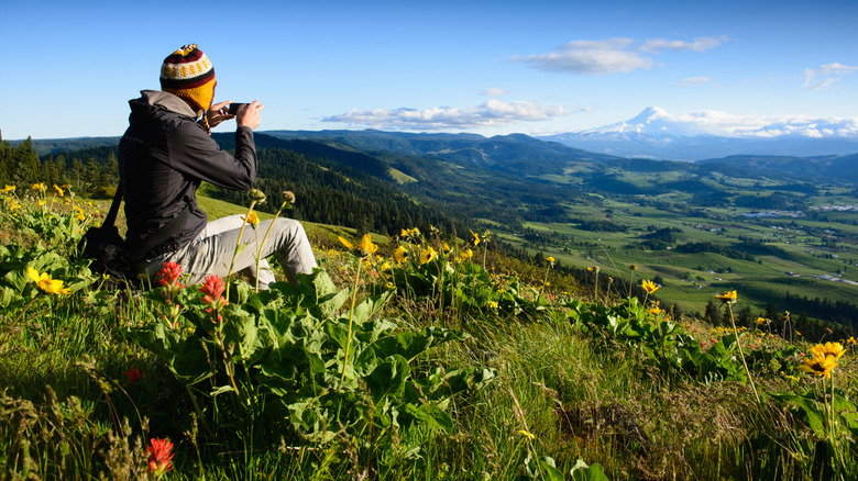
The Timberline Trail is a loop that wraps around Oregon's highest peak, Mount Hood. Traditionally known as Wy'East, it stands tall at 11,244 feet, and the entire 40-mile circuit is known as one of America's hardest hikes. On top of the trail's majestic peaks, you'll be treated to stunning waterfalls and otherworldly views, which make the brutal climbs worthy of your endeavors. It starts at Timberline Lodge on the south slope of Mount Hood, just over an hour from Portland, and as you make your way around, you'll see the mountain from different perspectives. Mounts Jefferson, St. Helens, Adams, and Rainier make guest appearances, too, while Portland and the Columbia River can be seen in the distance for much of the hike.
River crossings are the primary reason this multi-day journey needs to be taken seriously. Meltwater pours off the mountain, creating crossings that demand attention — because most are unbridged. The Coe crossing requires boulder hopping and is considered among the scariest by hikers, but the U.S. Forest Service also names the Newton, Muddy Fork, Sandy, and White rivers as challenging. Plan your crossings for the morning before the heat of the day swells their flow. The wind can also be fierce, so pack layers you can easily reach for. The loop usually takes four days to complete. It isn't easy, but if you make it back to Timberline Lodge in one piece, a renowned breakfast buffet awaits.
Skyline Trail, Washington: A steep hike with unbelievable views
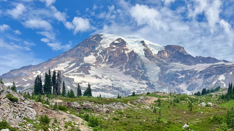
For well over a century, the Skyline Trail in Mount Rainier National Park has drawn hikers from across the country. It's a steep, demanding trail, and the exposure can be relentless, but it can be done in a single day, and the payoff is enormous. The 5.5-mile trail is well-maintained, and hikers on AllTrails consider it one of the best day hikes in the region. Over on the Washington Trails Association, one traveler said: "Probably the most beautiful day hike I have ever done."
The meadows on the way up are bright with wildflowers through July and August, and hoary marmots lounge across the trail while mountain goats graze. The path climbs to Panorama Point at just under 7,000 feet, where you'll see Tahoma, Mount Rainier's Indigenous name, towering over you and the Nisqually Glacier sprawling below. It's quite the sight, and on a clear day you can even see views beyond the park to Mount St. Helens, Mount Adams, and, just visible on the horizon, Mount Hood in Oregon.
One AllTrails hiker arrived on a foggy day and found that the weather only added to the experience: "We couldn't see all the beauty until we got to the very top and it looked like we were above the clouds." On the way down, the loop passes Myrtle Falls, a cascading veil of water that spills down over dark rock and is a sight that may well be worth your efforts alone.
Mt. Storm King, Washington: A short but punishing hike worth the view
The first mile and a half on the trail to Mount Storm King in Olympic National Park may lull you into a false sense of security because this section barely counts as a hike. It's flat and easy, with little to suggest what's around the corner. Once you hit the turnoff, the trail tilts sharply upward through humid forest, and the trees change from evergreens to gnarled, red-barked madronas and manzanitas growing between old-growth cedar and hemlock. The climb is relentless, and while May through October is the best time to hike, snow can show up on the upper sections at any time. It's only 4.3 miles out and back, but it feels much longer thanks to the 2,100-foot elevation gain.
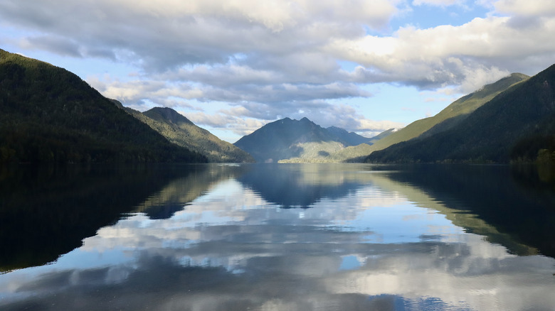
But it is stunning. Below, Lake Crescent, the second-deepest lake in Washington, fills the views, while beyond, you'll see the Strait of Juan de Fuca. You'll get more fantastic views at the end of the maintained trail, but beyond that point, it becomes neglected. It narrows to an exposed scramble with ropes fixed into the rock. You can only go one person at a time, and this is where many hikers have been hurt. Search and rescue teams are called out several times throughout the year, so make your decision about whether to proceed wisely. One Redditor said, "It's tougher mentally than physically, for sure." If you survive and make it back down, Marymere Falls is a short detour from the main trail and an excellent spot to calm your nerves.
Rattlesnake Ledge, Washington: A quick hike with big rewards
You can see the cliff face of Rattlesnake Ledge from across its namesake lake, the moment you step out of your car. From there, it looks like a serious climb, but the reality is, it's not as tough as it looks. The trail is just a short drive from Seattle, and with carefully laid-out switchbacks making up the roughly four-mile out-and-back hike, it's a steady climb as opposed to a grueling one. It's family- and pet-friendly, though the ledge itself is an open slab of rock with nothing between you and a long drop, so keep everyone close by.
The path climbs through young forest past boulders thick with moss, and from the top, you can see Mount Si and the Cedar River watershed stretching beyond. Look down, and you'll also see paddlers and swimmers enjoying Rattlesnake Lake if the weather is warm. However, if you're not enjoying the crowds on the ledge, there are two higher viewpoints with fewer people and wider views.
One AllTrails reviewer did say there were "so many freakin' people. Even on a cold rainy Saturday" — but it is busy for a reason. Hikers on that website rate it as one of the best short hikes in the state. However, another way to escape the masses is to extend the day with a loop around the lake below. There, you'll find massive old tree stumps lining the shore, with crowds thinning down to almost nothing.
Sawtooth Lake, Idaho: A steady climb to Idaho's most striking lake
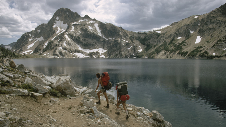
Local hikers consider the Sawtooth Lake hike to be the definitive trail in the Sawtooth Wilderness. The 9.6-mile out-and-back trail climbs 1,817 feet, and at your destination, you'll see Mount Regan rising 10,188 feet above with its steep gray slopes streaked with snow, mirrored in near-perfect symmetry on the lake. The water shifts between a deep blue and vivid turquoise depending on the light, and on still evenings, the peak burns with soft orange at the summit. Kristen Bor of the reputable outdoors blog Bearfoot Theory said, "At every corner and switchback, the trail gets more exciting," but also mentioned, "The hike itself isn't too tough considering all of the visual distractions."
However, the route includes a few creek crossings and stretches of steep, exposed rock along the way. One Redditor agreed that "it's a moderate amount of effort for amazing views." Alpine Lake is another stunning spot on this trail and is well worth the 100-foot descent from the main trail at 3.8 miles. The emerald green water is strikingly clear, but if you don't fancy the climb down, you can still get a good view from the switchbacks that follow. July through September is the best time to hike the trail, but it is the busiest time of the year. That said, when you feel like you are "walking through a postcard every second of the way," as one Redditor said, it's definitely worth sharing the experience.
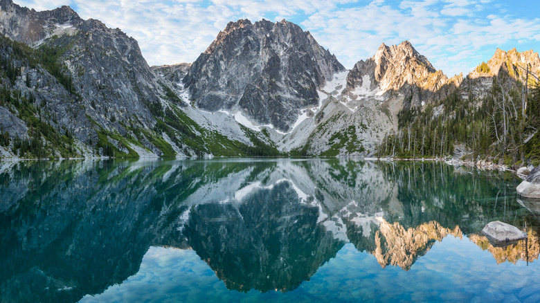
Colchuck Lake, Washington: A tough climb to a jaw-dropping lake
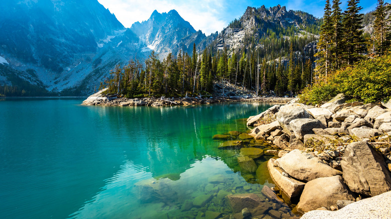
One AllTrails hiker said they "cried tears of joy" after arriving at Colchuck Lake in the Okanogan-Wenatchee National Forest. They went on to say, "The views of the snow on the trees with the sun shining was absolutely magical ... truly a winter wonderland." This is very high praise, but it really is that kind of place. The water is one of those bodies of water in America with unbelievably vibrant blue Gatorade-colored hues. Dragontail and Colchuck peaks can be seen rising sharply above at the far end, dominating the skyline. From the water's edge, you can also see Colchuck Glacier and the steep slash of Asgard Pass, the gateway to the Enchantments.
The hike to get there is an 8-mile round trip with an elevation gain of 2,280 feet. It can take anywhere from five to eight hours, depending on your pace, but not everyone is blown away by the actual trail — it's the lake that makes the hike worth every step. As one AllTrails hiker said, "The lake is beautiful, but the hike up is not particularly noteworthy." The opening stretch is pretty gentle. It follows a creek through forest for a mile and a half before getting steeper and a little rougher in the second half. Along the way, you'll see a beautiful waterfall, while just before Lake Colchuck, the trees open up to some sweeping views of Mount Stuart. Then, of course, you're treated to those eye-watering views at the lake.
Trail of Ten Falls, Oregon: A family-friendly waterfall marathon
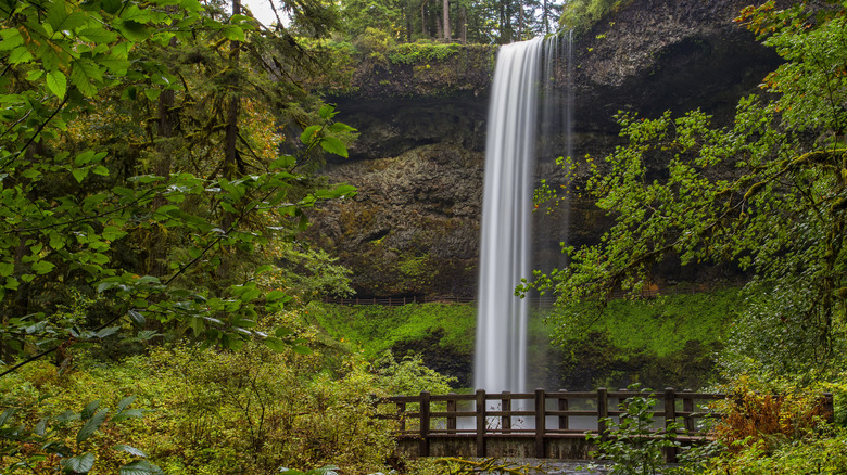
Silver Falls State Park is often referred to as the "crown jewel" of the Oregon State Parks system, and one of the main reasons for that is one of Oregon's best waterfall hikes: the Trail of the Ten Falls. This 7.2-mile loop is just over an hour from Portland and is officially recognized as a National Recreation Trail. And with 10 stunning waterfalls to enjoy across the hike, you can easily see why. They range in size from 27 to 177 feet, and one Tripadvisor reviewer said, "The falls explode with cascading, tumultuous, never-ending sheets." You can even walk behind four of them through gaps in the cliff face for some close-up moments behind curtains of falling water. South Falls is the biggest and most famous, and the walkable space behind it is one of the most photographed spots in the park.
Afterward, the trail drops into a canyon thick with Douglas fir, fern, and moss, following a creek winding along the bottom. The path is in good shape throughout, and the elevation gain is a fairly gentle 800 feet. It's easy enough for children, and there are benches to rest on between falls. Calm pools along the creek are great for cooling off in the summer months, and by mid-October, the maples in the surrounding forest turn, and the park gets a brief run of autumnal color. Over a million people enjoy the state's most majestic waterfalls, and most of them leave with a sense of wonder. One hiking blogger on The Packable Life even said they had "never hiked anything like it, and honestly, may never again."
Chain Lakes Loop, Washington: A moderate loop through volcanic scenery
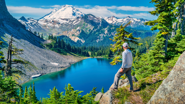
"Earth crafted a masterpiece here," wrote one AllTrails hiker while commenting on the Chain Lakes Loop. It's hard to argue, really. This 6.5-mile loop in the Mount Baker-Snoqualmie National Forest climbs 1,820 feet to Herman Saddle, sitting at 5,400 feet. Here, the North Cascades unfold around you, with the massive, snow-covered bulk of Mount Baker filling the western sky. To the east is Mount Shuksan, the Lummi people's word for High Peak. Its jagged, snow-draped slopes rise above dark evergreens, while its crags and ridges press sharply against the blue sky. At dusk, the rocky face washes over with a cold purple light that makes it look both serene and imposing. Few mountains anywhere are photographed as often, and you'll likely need more than one shot to justify it.
Between these two stunning peaks, the trail drops down past a string of alpine lakes. Iceberg, Hayes, and Mazama are all scattered through the basins below. Iceberg glows bright under sunny skies. Hayes is darker in color and sits between fir trees and sunlit ridges. The two Mazama lakes are a deep green and lie cradled beneath the bright snow‑washed peaks. The shorelines are rocky, and in summer, the lakes are warm enough for swimming, while the trails are dog friendly and moderate enough for kids. Spring brings wildflowers to the meadows, and in late summer, blueberries grow. By autumn, the hillsides are on fire with color, and one WTA hiker wrote in their trip report that it's "still one of the most beautiful and rewarding, easily accessible hikes in the North Cascades."
Naches Peak Loop, Washington: An easy walk with outsized views
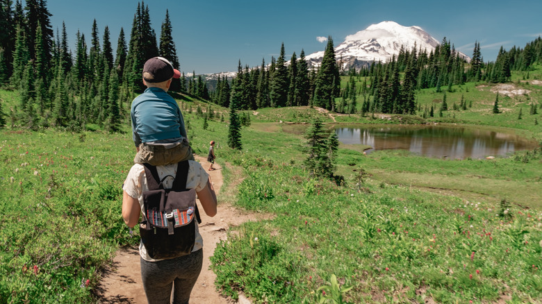
You'd be forgiven for thinking you had already reached your destination at the start of the Naches Peak Loop. Before you've even begun walking, Mount Rainier's snowy dome reflects off the still blue water of Tipsoo Lake. It makes for the perfect start to one of the most beloved hikes in Mount Rainier National Park. Doing the loop clockwise, you'll pick up a stretch of the Pacific Crest Trail (PCT) as it wraps around the north side of the picturesque Naches Peak. This broad, rounded subalpine mountain is surrounded by snowfields and wildflower meadows dotted with blues, whites, and magentas.
The trail then climbs above the green valley, and you'll see a line of distant peaks stretching out to the north before arriving at a rocky ledge looking down on the blue-green waters of Dewey Lake. This is a splendid place to stop for lunch before the trail curves southward, where many hikers say the scenery really comes alive. Mount Rainier takes over the views ahead. The wide, snow-capped volcano looms above rolling green meadows, with scattered firs and ponds spread out below the glaciated slopes. You'll end the loop back at Tipsoo Lake, where it's easy to hang around for another hour or so. The whole loop is just 3.5 miles, and the 500-foot elevation gain is manageable for most. One AllTrails hiker simply said it's "a lot of payoff for an easy trail," so it's a rewarding and stress-free day out for families.
Methodology

We trawled through Reddit threads, Facebook hiking groups, AllTrails reviews, and well-known travel blogs looking for PNW trails that travelers keep close to their hearts. What we discovered was a collection of hikes that people keep returning to and recommending to strangers online, with descriptions that go well beyond the scenery. So get your gear packed and hit some of these all-time best PNW hikes, and the memories are sure to stay with you long after the mud has dried on your boots.