The Secret Blue Ridge Mountain Trail In Shenandoah National Park That Most Tourists Miss

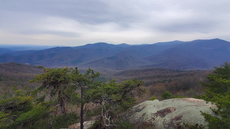
If you've ever visited Shenandoah National Park, chances are you've seen Oventop Mountain. Hulking over Sperryville, Virginia, this 2,467-foot peak is hard to miss from the park's central and northern districts. It's one of the prominent peaks in the Blue Ridge Mountains, featuring a prominence (how high the mountain stands above the surrounding area) of 686 feet. Despite the lofty views, few visitors make the effort to scale this imposing mountain.
The National Park Service (NPS) doesn't keep records of the number of people who climb Oventop Mountain each year, but it's undoubtedly a tiny number, given how hard it is to find information about this hike. In fact, you won't find a single review on Google Maps, and the most detailed blog post about the hike dates back to 2018. However, according to a SummitPost report, not much has changed over the years.
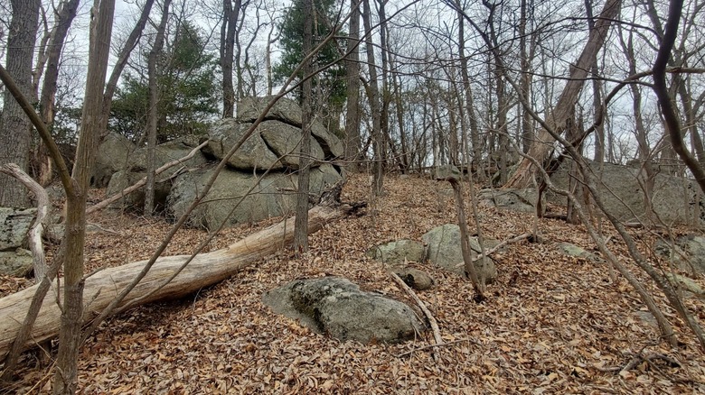
The hike to Oventop Mountain is still a strenuous ascent with over 1,100 feet of elevation gain and requires a good deal of bushwhacking along an unmaintained route to reach the summit. It's not a beginner-friendly trail and should only be attempted by hikers who know what they're doing. However, if you follow the park's guidelines for backcountry trip planning (really look at them), set out with a buddy, and follow the "STOP" mnemonic if you get lost, this mountain ascent offers stunning views of the surrounding mountains and zero crowds.
How to hike Oventop Mountain
The trail to Oventop Mountain is "secret" not because hikers gatekeep the route, but because it's not super easy to locate or follow. You won't find a designated Oventop Mountain Trail or step-by-step instructions provided by the NPS. Instead, hikers recommend starting from the Pass Mountain Trailhead along U.S. 211, about 4.5 miles from Sperryville, an artsy haven for beer lovers, foodies, and explorers. Important: This isn't the Pass Mountain Trailhead along Skyline Drive.
Although some hikers recommend looking for a cement post that marks the trailhead, this marker isn't clearly visible from the road. Instead, use the Thornton Gap Area Road Map provided by the NPS, and look for a gravel pull-off on the side of the road near these Google Maps coordinates.
Starting from the Pass Mountain Trailhead, you need to hike 1.8 miles to reach the main summit. Follow the Pass Mountain Trailhead for about 0.6 miles until you reach a sharp leftward curve in the path. From here, turn right and follow the ridge until you reach the main summit. This section of the trail isn't maintained and may require a good deal of bushwacking, depending on the time of year. Hikers report that the trail disappears, but you'll be able to reach the summit by sticking to the ridge. Make sure you have a GPS map in case you lose track on the trail.
What is the Oventop Mountain hike like?
The hike up Oventop Mountain is best for peak baggers, hikers who try to climb every peak in an area or on a list, and experienced hikers seeking solitude. The climb up is difficult, and some hikers find the views from the main summit less than thrilling. However, if you continue past the main summit, you'll find several peaks with impressive vistas. "Not far past the main summit, the trail descends slightly and passes some rocks (the rocks are to the left of the trail). Scramble up these rocks, which are almost as high as the main summit, for excellent views to the north of The Peak and Mount Marshall and southwest to Marys Rock," per the SummitPost report. Keep in mind that, like the rest of the trail, this section is unmaintained and requires scrambling over rocks.
Those looking to spend the night in the park can choose from one of the best camping spots in the Blue Ridge Mountains. Alternatively, backcountry camping permits are available, but hikers must apply for them in advance by phone or online.