This Little-Known Arizona Arch Just Outside Of Las Vegas Is A Natural Wonder Resembling The Liberty Bell
If you love finding places to visit with few people but plenty of adventure, Arizona is the gift that keeps on giving. From secret routes to drive down to the bottom of the Grand Canyon to a hidden natural water park — complete with slides, cliff jumps, and clear pools — there's always something new to uncover in one of America's youngest states, a mere 113 years old.
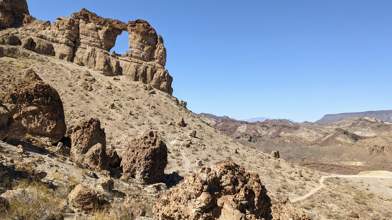
This time, we're planning ahead and heading into a quiet, beautiful stretch of desert to find something a little patriotic, just in time for America's 250th birthday. Lace up your hiking boots, we're off to see Liberty Bell Arch, named for the Liberty Bell, a symbol of American freedom. But this one wasn't cast in bronze, it was carved by wind, time, and the wild desert itself.
Located 40 minutes from Las Vegas, the hike to Liberty Bell Arch offers a 5.5-mile round trip with stunning views and unique desert landscapes. If you've had your fill of the bright lights of the Strip, a quiet adventure might be just what you're looking for. Just be sure to plan ahead: sturdy hiking boots, plenty of water, sunscreen, and hiking poles are must-haves for this trek. Timing matters too, as this trail closes during the peak of summer (May through September) to protect hikers from the scorching Arizona heat. If you've missed the window, add this to your 2026 trip list, when America celebrates the Semiquincentennial.
Getting there and what to expect
To get to this little-known hiking spot, travel south on Interstate 11 from Las Vegas. Cross into Arizona over the Hoover Dam, where the highway becomes U.S. 93. If you've never visited the Hoover Dam, it's worth a stop to see this modern marvel of engineering. You could also take a detour into Boulder City, a charming Nevada town with deep ties to the dam and a historic downtown.
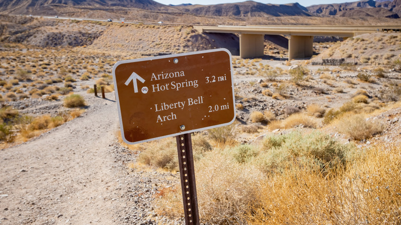
If you're in a hurry, or the weather is warm, you might want to head straight to the trailhead. Once you arrive, you'll most likely find ample parking early in the day, and you may notice that many people are actually headed to the more challenging Arizona Hot Springs. They share the same trailhead, but offer very different experiences. The hot springs have been ranked the "best natural hot springs in the U.S.," but reaching them requires a strenuous hike, and recently, several hikers needed to be rescued. As with all hiking adventures, know your limits.
This isn't a maintained trail, so download the map ahead of time or keep it open on your phone. Signs are posted, but it's easy to miss the fork where you'll head toward Liberty Bell Arch instead of the hot springs. Once you're on the right path toward Liberty Bell Arch, you'll find yourself walking through soft, sandy conditions after crossing under a bridge. You may need to stop a few times to empty your boots. There's also no shade along the way, so you'll be exposed to the elements the entire time. Take your time and soak in the desert views and a few unexpected places to explore.
Wildlife and World War II mining await
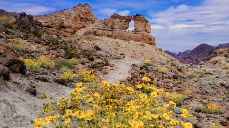
Along the way, there are interesting sights to see, including wildflowers in spring, cactus, and a small slot canyon. It's not nearly as dramatic as the canyons of Utah or Arizona's less crowded Antelope Canyon X, but it's a fun detour. You'll also pass the remnants of a World War II-era magnesium mining camp, an unexpected find in the middle of the Mojave Desert. You might even spot wildlife like bighorn sheep or lizards. Of course, be mindful of snakes, scorpions, and other desert creatures, especially in the warmer months. The nearest hospital is about 11 miles away, so always hike prepared. This trail is dog-friendly, but if your pup isn't trained in rattlesnake avoidance, you might want to leave your buddy behind.
Expect about 600 feet of elevation gain as you approach the arch. Just when you think you've missed it, you'll realize Liberty Bell Arch is right there, you just need to move around to spot it. It's hard to believe this stunning arch was created entirely by erosion. Climb up the hill a little more to grab selfies to prove this place really exists, or continue another half mile to the overlook of the Colorado River and add another 400 feet of elevation gain. You might even spot kayakers below. There is no access to the cool water here unfortunately, so as you make your way back down the trail, keep hiking poles ready to steady you on the sand.