These Are The Most Breathtaking Road Trips Along The West Coast, According To Travelers
A road trip is often the best way to explore a region, but hitting the road along the West Coast of the United States is even more special because it offers some of the most stunning scenery in the country. From the palm tree-lined beaches of Southern California to the rugged coastline of the Pacific Northwest, road-tripping offers a close look at the diverse landscapes. Beyond the famous Highway 1, the West Coast is also home to vast deserts, sand dunes, lush mountains, waterfalls, turquoise lakes, and towering redwood trees.
Different journeys will take you through sweeping ocean views, majestic redwood forests, and charming small towns. Whether you want a shorter road trip through the desert or an epic adventure traversing the coastline over multiple days, there's a route for everyone. I have personally driven many of these road trips, but I have also consulted travel blogs, travel Instagram posts, and road trip travel forums to ensure we are covering the best of the coast. Next time you visit the area, rent a car and hit the road on one of these breathtaking road trips along the West Coast.
Highway 1 from Dana Point to Monterey, California
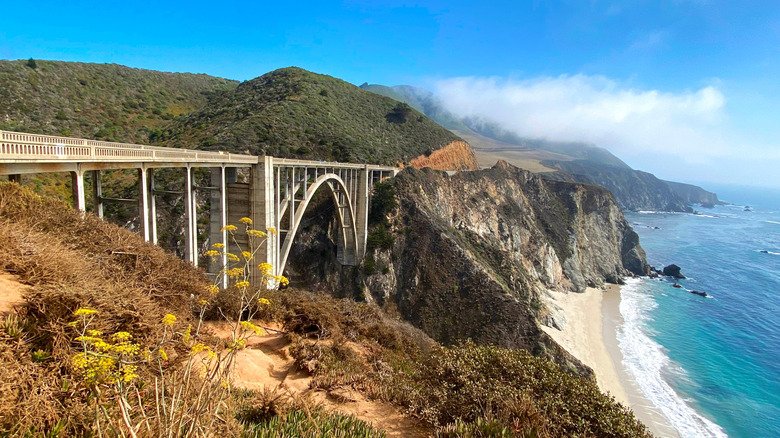
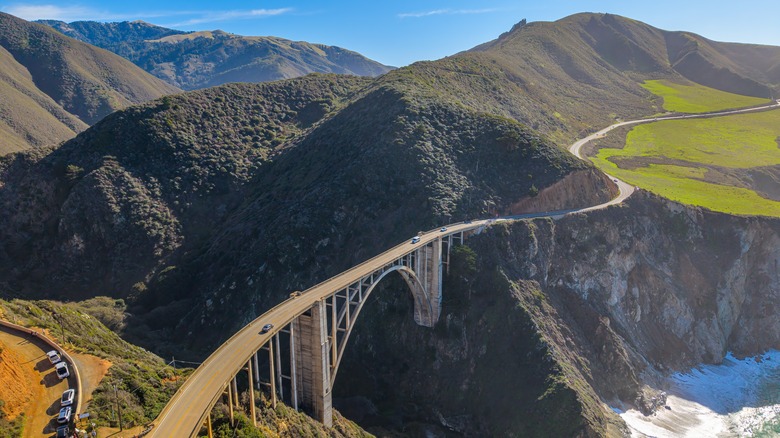
The most famous West Coast road trip is undoubtedly Highway 1 along the coast of California. The highway starts at Dana Point and ends near Leggett, but to drive the entire route is quite an undertaking. Many people drive to the most popular and iconic section of the highway, which is the area around Big Sur, from Dana Point to Monterey. Big Sur is famous for its natural beauty and remains relatively rugged and undeveloped, though it also offers various types of lodging, including glamping and luxury all-inclusive resorts.
There is so much to see along this route that you really should not rush the drive, which is roughly 500 miles long from Dana Point to Monterey. One Redditor says that the views north of Cambria get especially scenic. You will pass by beach towns, Hearst Castle, the famous Bixby Bridge, an elephant seal rookery, and the fairytale-like Carmel-by-the-Sea. Take your time to ensure you enjoy the best of what the California coast has to offer. Stop at Point Lobos State Natural Reserve and you might be able to spot some whales and sea otters. The Big Sur area is prone to landslides, though, so keep in mind that certain parts may be closed to road traffic and check highway conditions before you start your drive.
U.S. 101 from Los Angeles to San Luis Obispo
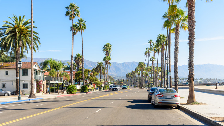
Highway 1 is not the only scenic coastal route in California. The U.S. 101 hugs the coast from Ventura to Gaviota and is also worth the drive. Take a road trip north on the 101 from Los Angeles to San Luis Obispo for a shorter getaway. The two cities are less than 200 miles apart. Plus, we think San Luis Obispo is one of the most underrated cities in America and perfect for a relaxing weekend away. I've done this drive many times and always love the ocean view as I get closer to the halfway point, Santa Barbara.
Nicknamed the American Riviera, Santa Barbara is a great place to stop for its Spanish Colonial architecture, delicious restaurants, and wine tasting rooms. Hike to the wind-carved caves at Gaviota State Park before the road turns inland toward the Santa Ynez Valley, an area full of wineries. Take a detour to Solvang, a cute town known for its Danish-style architecture. Then, stop by Santa Maria for a bite and taste tri-tip smoked over red oak. In San Luis Obispo, you'll find small town charms, the kitschy but iconic (and unmistakably pink) Madonna Inn, and a walkable downtown with great locally owned restaurants.
Volcanic Legacy Scenic Byway
Travelers love road tripping along the coast, but a bit further inland is the 500-mile-long Volcanic Legacy Scenic Byway, which is not only designated a National Scenic Byway, but one of only 42 All-American Roads in the country. To be an All-American Road, it must offer an exceptional travel experience and be a one-of-a-kind destination, so you know that this road trip is going to be outstanding (other All-American Roads in California include the famous Highway 1 and Route 66). One Redditor says this is a bucket list trip, especially if you like volcanoes, waterfalls, and caves.
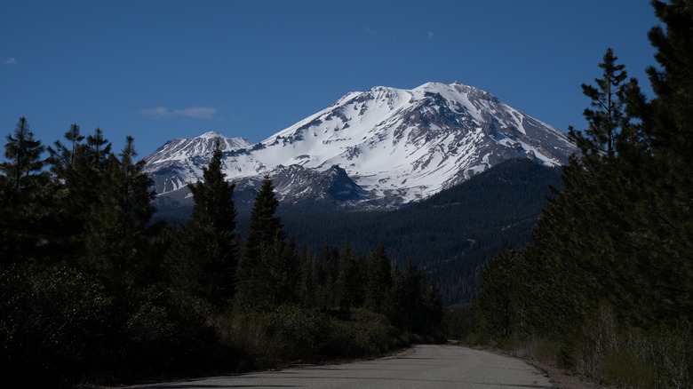
As the name suggests, this road trip route takes you to five volcanoes in the northeastern part of California and southern Oregon, passing through old mining towns along the way. Start by spending a couple of days exploring the mud pots and hydrothermal areas of Lassen Volcanic National Park, then head north to Mount Shasta before exploring the lava-formed caves at Lava Beds National Monument. The scenic byway also passes by a few waterfalls including Burney Falls. Afterward, cross the state border into Oregon and visit Medicine Lake Volcano and Crater Lake National Park. The latter is home to the deepest lake in the U.S.
Highway 395 to Lake Tahoe
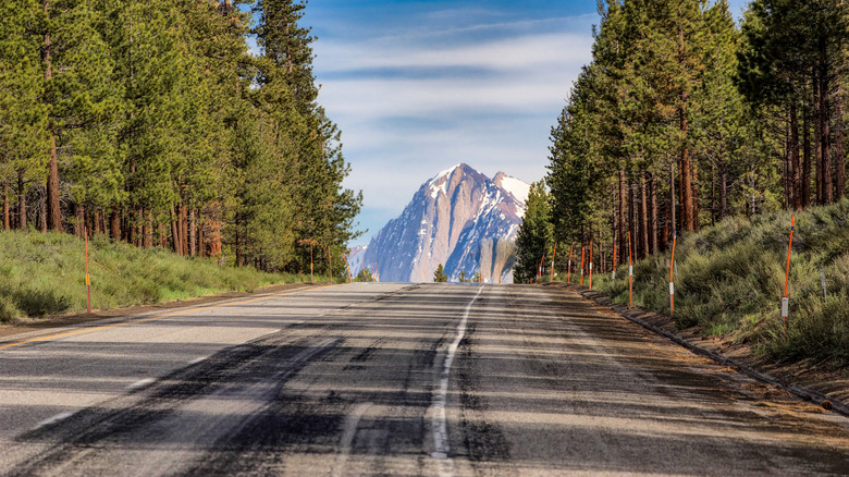
U.S. Highway 395 stretches 1,300 miles long, but don't worry, we're not telling you to drive the entire length. The section of Highway 395 in California that you should explore goes from just north of the San Bernardino National Forest to Lake Tahoe, which is roughly 400 miles. Travel influencer Asya Olson calls this "one of the prettiest road trips in California," and especially likes the section between Big Pine and Lake Tahoe.
Before you get to Big Pine, though, you'll also pass by Alabama Hills, which is known for its rock formations. Then there's Manzanar National Historic Site, an important historical monument where thousands of Japanese-Americans were incarcerated during World War II. Between Big Pine and Lake Tahoe, the drive will take you past multiple lakes. If you have time, it's well worth going on a hike or kayaking on one of the lakes. Stop by Mono Lake to see the tufa towers, and visit the Bodie ghost town (now a State Historic Park). Of course, when you get to Lake Tahoe, continue your road trip around the iconic Lake Tahoe and visit highlights like Emerald Bay State Park and Zephyr Cove.
Waterfall Loop in the Shasta-Cascade
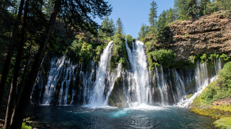
TLC might tell you not to go chasing waterfalls, but we say you should. Northern California's Shasta-Cascade region is known as the Waterfall Mecca, and there's a driving loop that will take you to visit 13 of them in the span of around 200 miles. The drive starts from Redding and either goes north on Interstate 5 or east on California State Route 299. The two roads are connected via CA State Route 89.
Depending on how much time you have, you may not be able to visit all 13 waterfalls, but there are some you should not miss, including Burney Falls. This is a wide, cascading waterfall and one of the prettiest I've seen. Meanwhile, behind Hedge Creek Falls is a cave that you can enter, offering a different view of the falls. Then there are the three tiers of McCloud Falls near Mt. Shasta. The town of Mt. Shasta is your best bet to spend the night with multiple lodging options like Summit Lofts Boutique Hotel. This loop partially overlaps with the Volcanic Legacy Scenic Byway, so you may want to combine the two while you're in the area.
Napa to Mendocino
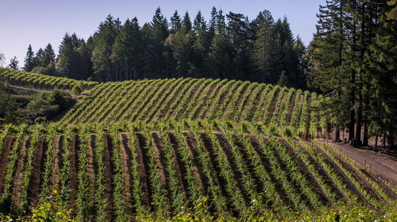
Vineyards, redwoods, and coastal views are all included in this short Northern California road trip from Napa to Mendocino. There are generally two main routes you can take to Mendocino, but if you're visiting the famous Napa Valley, you can continue to Mendocino via CA State Route 29 and make a stop at California's own Old Faithful Geyser in Calistoga. Afterward, hop on Highway 128 and drive through Anderson Valley, a lesser-known wine region in Mendocino County. You can stop by various wineries for wine tastings, like Roederer Estate's newly renovated tasting room, which offers excellent sparkling wines and sweeping views of the vineyards.
The small towns of Boonville and Philo may lack phone reception, but they also hide some great places to stop for a bite, including sushi and more at SŌBŌ Sake Bar in Boonville. Eventually, the vineyard views will end and be replaced by towering redwood trees. The road snakes through Navarro River Redwoods State Park, which offers serenity and hikes in near-solitude. Toward the end of the road trip, Highway 128 turns into Shoreline Highway, a portion of Highway 1, and follows the coastline up to the artsy town of Mendocino.
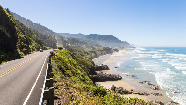
Eureka, California, to Oregon
From Eureka, California, the U.S. 101 highway continues north to Oregon. You can drive roughly 450 miles along the coast to Astoria, Oregon, to see some outstanding Pacific Northwest scenery. Don't miss a stop at Fern Canyon in Prairie Creek Redwoods State Park. It's a short trail that goes through a wonderfully lush, 50- to 80-foot-deep canyon lined with ferns. Trees of Mystery is a fun roadside attraction with a skywalk that traverses bridges suspended between redwood trees (you can't miss the giant Paul Bunyan sculpture out front).
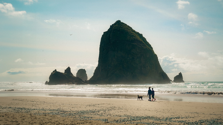
When you hit the Oregon border, explore the arch rocks and blowholes at Samuel H. Boardman State Scenic Corridor and the rock formations on Bandon Beach. If you have time, ride a dune buggy on North America's largest coastal dunes at Oregon Dunes National Recreation Area. There are a few beach towns along the way where you can stop to rest and refuel. Of course, you need to break for cheese and ice cream at Tillamook Creamery. Last but not least, Cannon Beach is a must on this road trip, as the beach is home to the famous Haystack Rock. Not only is this sea stack one of Oregon's iconic landmarks, but you might also catch a view of tufted puffins resting on the top.
Mendocino to Eureka, California
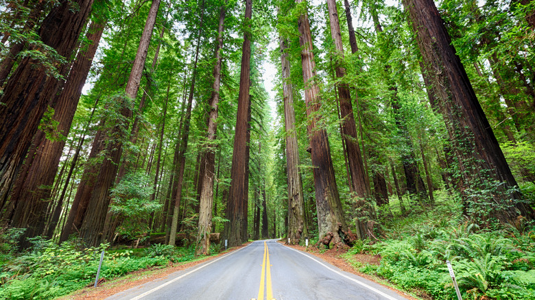
The famous Highway 1 ends north of Mendocino around the town of Leggett, but you can continue driving to Eureka via U.S. 101. For the rest of the Highway 1 drive, you can stop in Fort Bragg to explore the famous Glass Beach (although the glass on the beach isn't as plentiful now, as tourists keep illegally taking pieces home, but it's still interesting to see), ride on the historic Skunk Train, or have a pint at North Coast Brewing Company.
After Leggett, continue north on the U.S. 101, which is dotted with quirky roadside attractions. At some point, the road forks, and you'll want to make sure to get on the Avenue of the Giants. The 31-mile road is famous for being the most scenic drive through the redwood forests. The road is surrounded by the Redwoods State Park and includes a lot of stops to explore. Check out hiking trails through redwood groves and the Shrine Drive-Thru Tree. Don't miss the Immortal Tree, estimated to be almost 1,000 years old. The Avenue of the Giants eventually merges onto U.S. 101 again, but before you reach Eureka, you may want to take a short detour to the charming Victorian village of Ferndale.
San Diego to Anza-Borrego State Park via Julian
Travel influencer Asya Olson recommends the drive from San Diego to Julian with a detour at Mt. Laguna to drive along Sunrise Highway. From San Diego, head east and up in elevation toward the Cleveland National Forest, and turn onto the Sunrise Highway at Laguna Junction. Sunrise Highway is a county road that runs through the Laguna Mountains. At an elevation between 4,000 and 6,000 feet above sea level, it has scenic mountain views and offers a number of vista points to stop and enjoy the landscape.
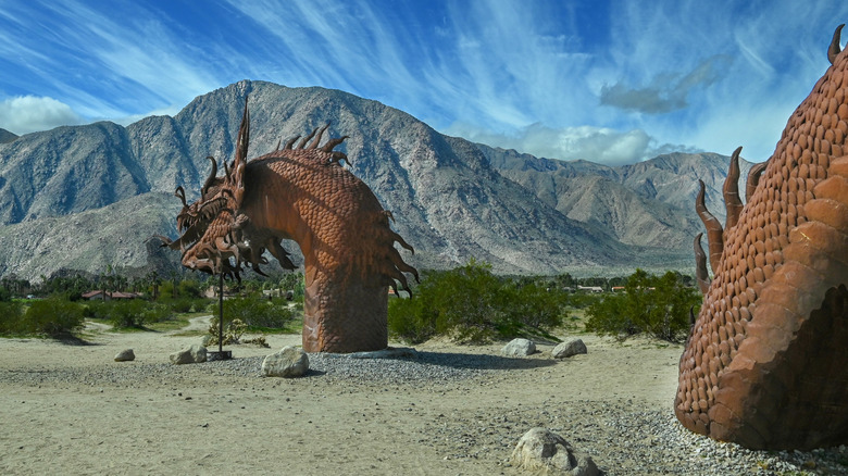
Shortly after Sunrise Highway ends, you'll arrive at the town of Julian, the Apple Capital of Southern California. Naturally, Julian is also known for apple pies, so be sure to grab a slice from one of the local bakeries. From Julian, head east for some desert views at Anza-Borrego Desert State Park and hike through the slot canyon. Try to stay up late because the park is known for its dark skies and it's the best stargazing destination in the country. From there, head north to Borrego Springs and drive around Galleta Meadows to check out all the large-scale metal sculptures in the area, created by metal artist Ricardo Breceda.
San Francisco to Mendocino
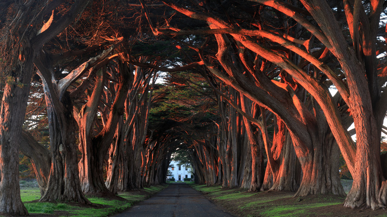
The drive from San Francisco to Mendocino only takes around three hours if you take the U.S. 101, but the slower, coastal route on Highway 1 is much more scenic with numerous stops along the way. Just north of San Francisco, you'll see Muir Woods National Monument and the 3-mile-long Stinson Beach. It's worth taking a day to explore Point Reyes National Seashore where you can walk under a tunnel of cypress trees, look at elephant seals resting on the beach, or get a chance to view some tule elks, which are only found in California.
Stop for fresh oysters anywhere between Point Reyes and Tomales. Tomales Bay is well-known for its mollusks. Further north, check out the architecture in Sea Ranch, climb up the 155-year-old Point Arena Lighthouse, and take a walk on any of the beaches that dot the coastline up to Mendocino. Blogger California Through My Lens particularly recommends the area from Jenner through Salmon Creek State Park. If you have the funds for a splurge meal, the two-Michelin-starred restaurant Harbor House awaits in Elk. You can also spend the night at the inn here, which includes a lovely Japanese-style breakfast that I can personally attest to as one of the best hotel breakfasts I've ever had the pleasure of eating.
Joshua Tree to Death Valley
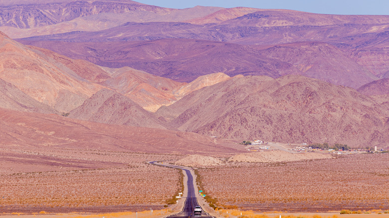
This short road trip takes you to two of California's desert national parks. Start by spending at least a full day exploring Joshua Tree National Park, getting to know the unique yucca plant and rock formations like Skull Rock and Arch Rock. From Joshua Tree, you can drive to Death Valley National Park in about four hours, but we recommend taking the scenic route instead.
Travel blogger California Crossings suggests adding Amboy Crater, Kelso Dunes, and Shoshone as stops on the map to get the proper routing for the scenic drive. The Amboy Crater is a cinder cone located in one of the youngest volcanic fields in the country and was used by NASA to test the Mars Rover. From there, head to Kelso Dunes to hike the sand dunes (hiking in the summer is not recommended), before exploring the unique ghost town in Shoshone. The town is called Dublin Gulch and consists of homes carved into the caves. The dwellings were used by miners and railroad workers in the late 1800s because the caves provided good insulation.
You should spend at least two days driving around Death Valley National Park itself because it is the largest national park in the contiguous United States. That's not its only claim to fame. Death Valley is also the hottest, driest, and lowest place in the country, so it's best to do this road trip outside of summer.
Methodology
As a travel writer living in California, I have personally driven at least a part of each of these road trip routes, and I recommend them as some of my favorites. To make sure I didn't miss anything, I also combed through posts from travel blogs, travel Instagram influencers, and travel forums on Reddit and other platforms. Because the article is about scenic road trips, I selected routes where the views from the roads are also beautiful, in addition to offering stops and destinations worth visiting along the way.