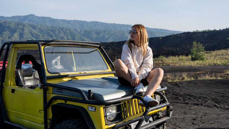
Travelers Agree That These Are The Scariest Drives In U.S. National Parks
Dotted on maps across the United States, the National Park Service offers a treasure trove of breathtaking destinations in a wide range of ecosystems and terrains. The problem is that getting into some of the dreamiest national park locales sometimes requires a bit of a white-knuckled drive — something I know from firsthand experience.
When I was growing up in the late '80s to early '90s, my family loved rolling around the country in our RV, often camping in the national park system's RV campsites as we traveled from our home in Oklahoma through the American South, all through New England, and up through the mountain states like Colorado and Wyoming. While my dad, an experienced semi truck driver and a fire engine operator with our city's fire department, never seemed to break a sweat driving our C-class camper over mountain roads, there were a handful of moments on those family vacations that caused my young heart to stop. Although decades have since passed, I'll never forget the sheer terror I felt as a young teen looking out the window as we drove through the winding roads of the Rocky Mountains with nothing but a straight drop down over the side.
The good news is that with a little planning, my fellow risk-averse drivers who don't love the idea of riding their brakes over serpentine roads can avoid the sketchiest park drives. Here's a breakdown of the worst offenders courtesy of users on sites like Reddit, YouTube, and Tripadvisor.
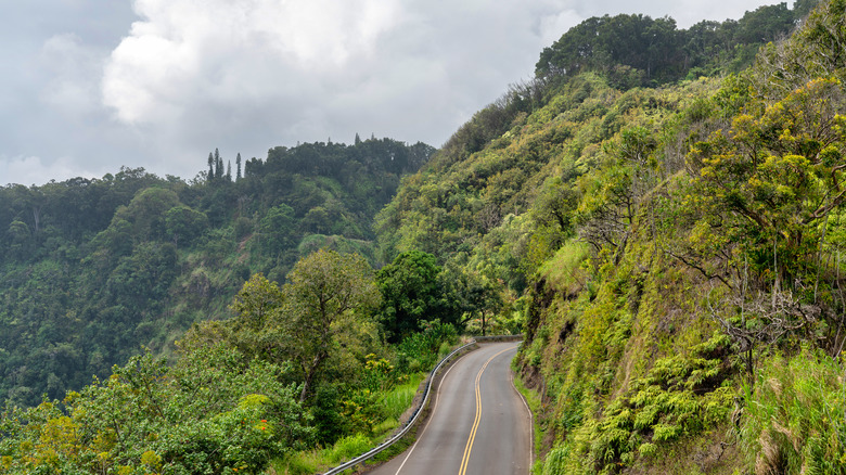
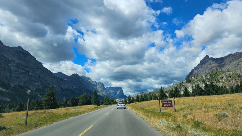
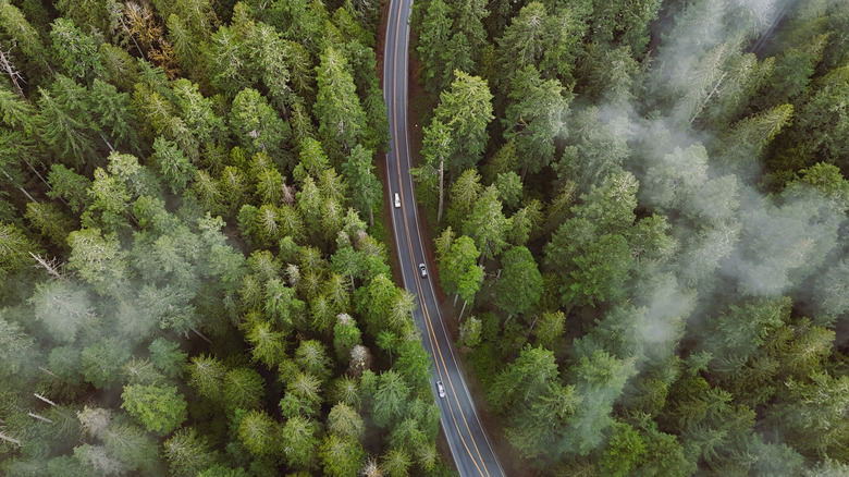
The north-south entrance to Sequoia National Park
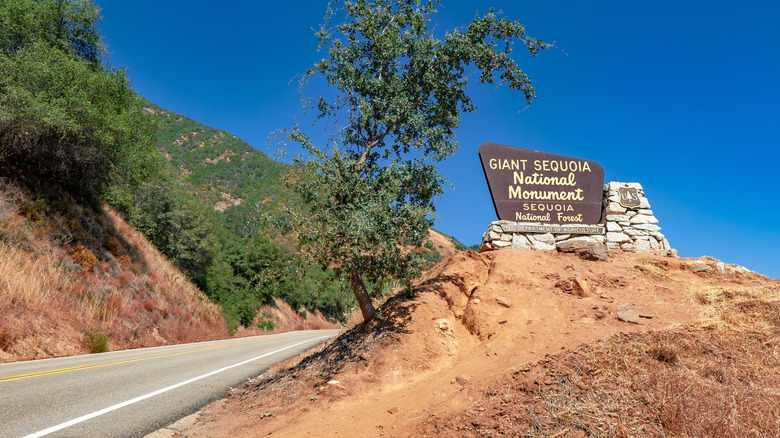
Standing in a grove of giant Sequoias can be a profoundly humbling experience. The world's largest trees, according to trunk volume, some of these stately giants are the height of a skyscraper and the width of a city street. Even more humbling, many have been maintaining their silent vigil since long before the fall of Rome. The enchanted Giant Forest most of the world's remaining sequoias call home, resides in California's Sequoia National Park, an awe-inspiring hidden gem and America's second-oldest national park.
Located in the southern Sierra Nevada Mountains, the park is also home to mountains, meadows, waterfalls, and hundreds of caves. But the same rugged terrain that yields such a cornucopia of natural marvels can make for a frightful drive on the way in, some travelers say. Writing on r/nationalparks, one Redditor complained of the park's north-south entrance thanks to its minimal to no guardrails and steep drops, writing, "One of the most terrifying things I've ever done." And one Tripadvisor user reported rounding curves on the park entrance's "scary winding road from Three Rivers" to nearly hit another vehicle traveling in their lane.
If you'd prefer to avoid all of that, reserve a spot on the Visalia-Sequoia shuttle that transports guests for just $20 round-trip per person or $35 per vehicle. Once you're inside the park, the shuttle offers unlimited service inside to locations like the Giant Forest Museum and General Sherman Trailhead.
The scenic byway en route to Kings Canyon National Park
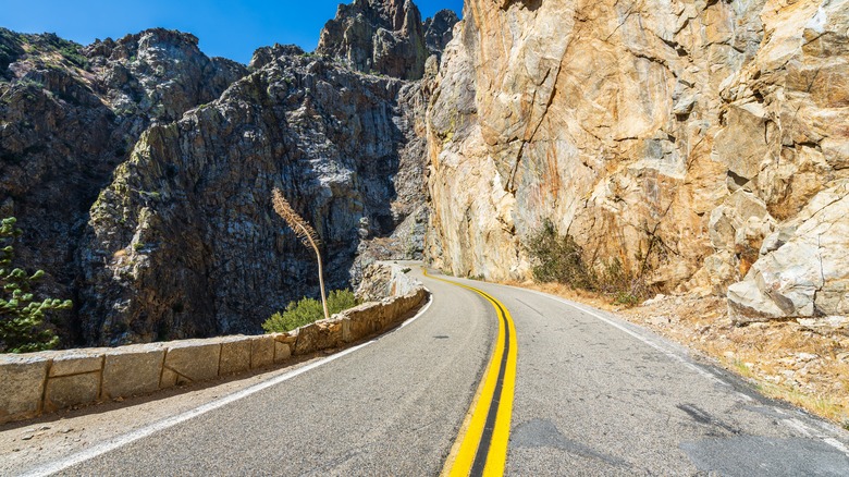
Technically run under the same park system as Sequoia National Park, Kings Canyon National Park has its own sequoia groves, caves, and trails, all on the edge of the High Sierra Mountains. And it also has its own entrance — a scenic byway that goes deep into one of California's most breathtaking canyons.
The 50-mile scenic route that follows Highway 180 begins just outside Fresno in the mountain foothills, winding through the Kings Canyon Grant Grove area before traveling down into Sequoia and then back up and out through Kings Canyon's Cedar Grove area. A winding, narrow, circuitous road, the highway is stressful enough by day but can be downright treacherous at night or under adverse weather conditions. Just take it from the Redditor who reported, "I went to Kings Canyon/Sequoia last week and the drive up to the cedar grove area was real sketchy thanks to the densest fog I've ever seen in person."
But some seasoned Kings Canyon travelers say it's mostly just the steep views psyching drivers out. According to many, you'll be fine if you simply drive slowly and carefully and keep your eyes on the road — and the view is more than worth the effort.
The high elevation drive into Rocky Mountain National Park
For years, I questioned whether my traumatic Rocky Mountain National Park experience had been real or the overactive imagination of an anxious teenager. Although those roads had seemed somewhat less menacing when I returned there on my honeymoon in a Honda Acura a decade later, it's easy to see how anyone used to flatter terrain might find them at least somewhat unsettling. And if you drive anywhere through the park when there's any amount of ice on the road, things can really get frightening — so much so that the park has been known to shut down some roads when that high altitude rain hits.
It's also a good idea to research any RMNP roads before taking them instead of exploring aimlessly. If you end up on the Old Fall River Road, a nine-mile single-lane one-way unpaved pass with no guardrails, steep drops, and narrow switchbacks, you might just feel like you're taking your life into your own hands. "I feel like the road could fall away from underneath us," Pauline of the Just Drive America YouTube channel complained in a shaky voice. "If I had seen this before we started, I would not have come." It's also a good idea to avoid Trail Ridge Road if you're not much for thrill-seeking.
And aside from its scarier passes, its ethereal and otherworldly settings like the glistening Emerald Lake make Rocky Mountain National Park well worth the drive — a drive that's not really that bad if you keep your eyes on the road. As my husband Justin put it, "Most of them are winding through valleys or around mountains."
The road to Hana leading to Haleakala National Park
Located on Maui island in Hawaii, Haleakalā National Park is home to an otherworldly landscape that feels a bit like a walk on Mars, courtesy of its namesake dormant shield volcano, meaning "house of the sun" in Hawaiian. Around the high-elevation summit that sits more than 10,000 feet above sea level are waterfalls, mountain streams, and scenic overlooks straight out of a fairytale.
The up to seven-hour drive to the park, known as the Road to Hāna, is among the most spectacular routes in the United States, so much so that for many tourists, the road is a destination in its own right. But with its heart-stopping twists and turns, this storied road is not for the faint of heart. As one Redditor wrote, "OMG Road to Hana nearly gave me a heart attack. I will never make that drive again." Another reported, "Maui mtn roads were the scariest I've ever driven."
If you want to see the national park and you're willing to skip the drive, you can hop on one of the shortest flights in America and trade the road views for aerial ones. Even better, hop on a tour bus so you can let the experts take over while your group gets to kick back and enjoy the ride.
The road into Yellowstone National Park (under one condition)
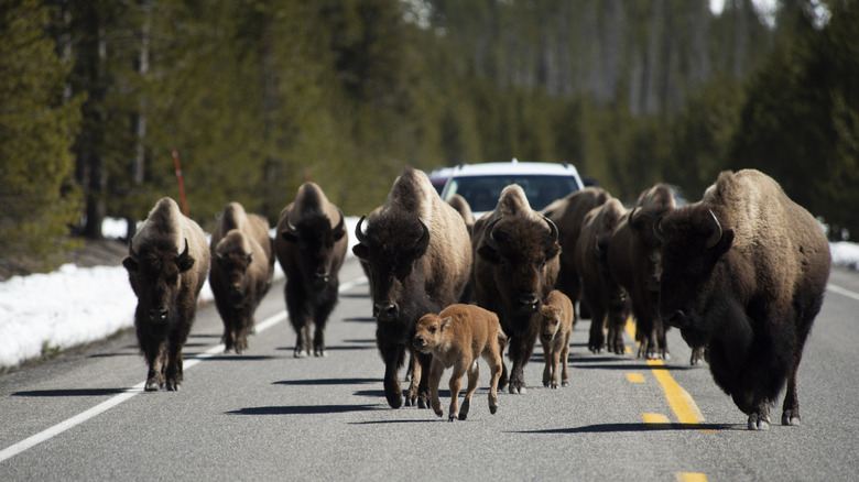
Boasting the world's largest concentration of hydrothermal features, hot springs, and geysers, Yellowstone National Park is like no place else on this planet. As a young teenager, I was mesmerized by the park's sapphire-blue pools and the strange, surreal feel of the landscape. Transformed into the world's first national park back in 1872, the massive 2.2-million-acre natural wonderland is one of the United States' most essential eco-sanctuaries and is home to the likes of cougars, grizzly bears, lynxes, wolverines, the country's largest free-roaming bison herd, and one of its largest elk herds.
Yellowstone actually spans three states — Montana, Idaho, and Wyoming — which means there are quite a few routes into the park, most of them perfectly safe under ordinary conditions. But visitors say if you happen to be driving in with a herd of bison, things can turn very hairy very fast. Reddit is full of frightening tales from park guests recounting up-close-and-personal brushes with bison herds that had them grasping for their rosaries with bated breath. Describing their bison encounter, one Redditor wrote, "We were like a boulder in a torrential river of buffalo. The car was rocking back and forth...It was so surreal, absolutely amazing, and scary AF." If it happens to you, remember these megafauna can weigh 2000 pounds, run up to 37 miles per hour, and won't hesitate to gore you if they see you as a threat. To stay safe, remain in your vehicle no matter what happens and avoid honking your horn or interacting with the creatures.
The thrilling drive into Mesa Verde National Park
Located in Montezuma County, Colorado, Mesa Verde National Park was home to the Ancestral Puebloans for more than 700 years and exists today as a World Heritage Site where visitors can honor their heritage by experiencing their advanced architecture and learning how they lived. Built into the cliffs here from 1190 to 1280 CE, visitors can tour North America's largest cliff dwelling, Cliff Palace, which served as a residence for up to 100 people when it was in use.
To get to the dwellings from the visitor center, visitors will need to endure another white-knuckled high elevation ride — and it's something of a long one. "The drive can be scary for those who aren't use to driving on overpasses or up sides of formations in general," one Reddit user advised. Recalling a decades-prior drive as a young child, another Redditor wrote, "I still remember the terrifying drive up lmao." Make sure you've got a full tank of gas before heading up the mountain and take your time on the drive.
The roads into Yosemite National Park
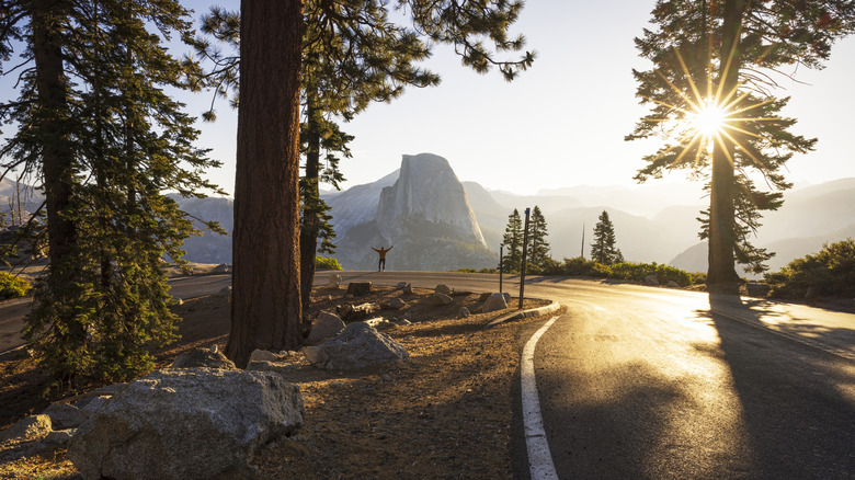
Carved out by glaciers eons ago, California's 1,200-square-mile Yosemite National Park is home to at least two dozen named waterfalls on any given day — a number that explodes when the snow melts each year. The jewel in its crown is Yosemite Falls, the stunning 2,245-foot waterfall system visible all around Yosemite Valley. Standing as both North America's tallest waterfall and one of the tallest waterfalls in the world, Yosemite Falls is the collective name for the whole of Upper Yosemite Fall, Lower Yosemite Fall, and the middle cascades.
To take in those heavenly views, visitors must first traverse some pretty intense high-elevation roads featuring gnarly steep drops. Describing the route on r/Yosemite, one Reddit user recalled, "Freaking cliff side drop offs every where!?...Those freaking intrusive thoughts better stop!!...Not a guard rail in sight!!!!! Why!!!"
Fortunately, as other folks in the know advised, the terror road isn't the only road through Yosemite. While it does take cars through a windier forest route, some travelers advised taking the south entrance (Highway 41 on Wawona Road). Still, more considered the All-Weather Highway (Highway 140) along the Merced River the best and safest route. And if you still don't want to drive, just hop on an eco-friendly Yosemite Area Regional Transportation System (YART) shuttle instead.
The St. Mary Road side of Glacier National Park
With hundreds of trail miles running through a celestial dreamscape filled with fjords, waterfalls, glittering lakes, U-shaped troughs, alpine meadows, and hanging valleys courtesy of the region's ancient valley glaciers, Montana's Glacier National Park is another rare jewel of the North American continent. And although the spectacular views are worth the effort to get there, r/GlacierNationalPark is full of discussions about how frightening the park's roads can be — particularly those on the east entrance. Think narrow, windy, bumpy, and generally uneven roads that are gravel in some places, and then throw in a healthy number of intense hairpin turns, steep drop-offs, and a complete lack of guardrails in many areas.
The two places I got the most scared driving in Glacier were driving between East Glacier and the St. Mary's Entrance. In my opinion, there were some very windy, narrow sections of that road, with drop-offs where people went way too fast for me.
Glacier National Park's Going-to-the-Sun Road is another intense route through the park. One Redditor advised, "Going to the Sun Road is considered one of the more stomach dropping main roads in our national parks." If you don't love the idea of a 1000-foot drop, past visitors suggest driving through the park very slowly and pulling over to let other cars pass if you're feeling pressured to pick up the pace. Visitors can also hitch a ride with a local shuttle system that connects to NPS's Glacier Park shuttles or sign up for a Red Bus Tour.
Death Valley National Park's serpentine roads
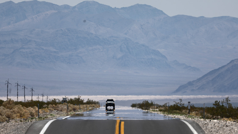
If you've never been, it might seem logical to assume Death Valley National Park is fairly flat based on the park's famed salt flats and Badwater Basin, the long-dry ancient inland lake that stands as the lowest elevation point in North America. But that assumption would actually be wrong. Marked by visible fault lines, fascinating rock formations, and other surreal landscapes, Death Valley is nestled between the fault-blocked mountain ranges: the Panamint Range and the Amargosa Range. And that means a whole mess of serpentine roads full of intense twists and turns. While not the worst mountain roads you can travel in a national park by a long shot, they can feel a bit treacherous to folks who don't do well with these kinds of roads.
As one helpful Tripadvisor user emphasized in their detailed discussion of Death Valley Park roads, getting to a place with such flat, low elevation necessitates driving through hilly regions to get there. How twisty the path is depends, therefore, on where a driver is heading from. The road from Las Vegas, they added, is pretty flat. While it is a bit intensely hilly, the short drive from Beatty, Nevada, is nothing to stress over. The road in from Emigrant Canyon — recently repaired after a 2023 flash flood — is the higher elevation route that takes vehicles through some narrow, winding paths. If you must nope out of it, it is possible to plot an easier — if more circuitous — path with a little clever planning.
Deer Park Road in Olympic National Park
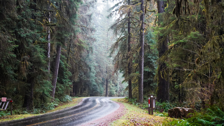
A million-acre national park stretching across the Pacific Northwest, Washington's Olympic National Park features several distinct ecosystems. Tidepools and cliffs line the park's wild Pacific coastline, which serves as a habitat for a whole host of marine life, including otters, gray whales, humpback whales, sea lions, orcas, dolphins, and harbor seals. Between the mountains and river valleys lie resplendent montane forests with their dense tapestry of firs, cedars, and hemlocks sheltering mountain wildflowers and a wealth of woodland creatures like cougars, elk, and bears. Likewise, the park's coastal forests, lowland forests, temperate rainforests, subalpine, and alpine regions have their own flora and fauna.
But among North America's mountain regions, some visitors say Olympic National Park ranks as one of the most treacherous when it comes to driving — especially when it comes to Deer Park Road. "This is one of those roads that is easier for the driver than the passengers," remarked one Tripadvisor user. "Sheer drops, tight corners and no room to pass." Other traumatized park guests used the platform to plead with others to just skip going altogether.
While this might be good advice for folks who don't tend to appreciate adrenaline travel, plenty of park guests say it's fine if you're careful and drive slowly. A handful even said those twisty roads made their trip more interesting.
Newfound Gap Road in Great Smoky Mountains National Park
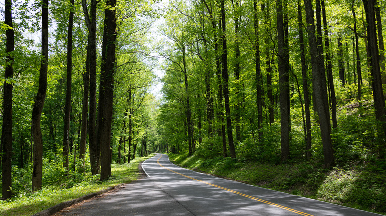
As someone who once sat in the back seat watching the car roll backward toward a frightening drop-off behind us as the shaken driver of the standard transmission Mini Cooper we were in got the yips on a steep mountain road, I can easily empathize with some drivers' aversions to precipitous inclines. Having driven through the Great Smoky Mountains a few times myself, I can also personally attest to how steep even some of the region's more mundane roads can be, something I have found almost disorienting in the past. And that's exactly why many on social media say Newfound Gap Road in the Great Smoky Mountains National Park is on their personal "do not drive" list.
At an elevation of just above 5,000 feet, Newfound Gap is one of the Smoky Mountains' lowest drivable passes, something that makes for a breathtakingly scenic drive through the mountains surrounded by dense, mature forest. But that also means the 33-mile road running between Gatlinburg, Tennessee, to Cherokee, North Carolina takes a steep path to get that low — a fact some drivers find deeply unsettling.
"I was nervous and scared for 32 miles. I hate heights and had no idea it went up for over 5,000 feet!," lamented one driver on Tripadvisor. If that doesn't sound like something you'd be into, other users suggested only taking Newfound Gap as far as Sugarlands Visitor Center but then switching to the less intense Little River Road or taking the Foothills Parkway.
Methodology
To find the steepest, curviest, most frightening National Park Roads, I started by drawing on my own experience and checking out what others were saying online about the frightening Rocky Mountain National Park roads that scared me as a kid. Next, I searched through Reddit to see if any other national park drives had managed to rack up a reputation for scaring drivers. After I'd found some recurring themes, I turned to YouTube and Tripadvisor to look for folks on those platforms with similar stories, and as always, the internet did not disappoint.