The Best Mountains Where You Can See Glaciers (Other Than In Alaska)
Getting to see a glacier on a climb is a humbling — and increasingly rare — encounter with overwhelming beauty. Glaciers carry tens of thousands of years of compacted snow and ice, creating a prismatic, sculpted landscape along mountain ranges. One of the most powerful things about seeing a glacier is that they're not immobile but rather are slow-moving ice tides — you can actually hear them cracking and hissing as they grind downslope and split apart. Because they require specific conditions of abundant snowfall and cold temperatures year-round to form, glaciers mostly exist in high mountains at the extremities of the world. That's why Alaska makes for a perfect glacial environment, home to countless icy behemoths like the Ruth Glacier, which is deeper than the Grand Canyon. Glaciers can be found all over the world, though, in vast mountain ranges from the Alps to the Andes.
Many glaciers are rapidly retreating, and seeing certain glaciers now might be something future grandchildren will only get to know from photos. A study published in Nature found that, since 2000, 39% of glaciers in Central Europe have been lost, while the Western U.S. has lost 23%, owing to general warming. These mountains around the world have some of the most spectacular glaciers that could change or disappear altogether within the century. They require some commitment to get up close to, with some requiring multi-day hikes or remote expeditions. But these journeys are well worth it for the once-in-a-lifetime views, and many offer equally exciting vistas along byways and train rides.
Sierra Nevada, California
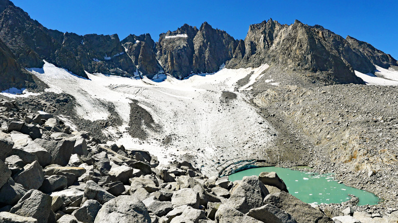
For many travelers in the U.S., California's Sierra Nevada mountains may offer the most accessible glacier-viewing opportunities. Glaciers can be found throughout the southern and central Sierra Nevada range, though their most magnificent and ancient are in Yosemite National Park. These glaciers could be short-lived, though: A study from Science Advances estimates that the Sierra Nevada glaciers, which have existed continuously for roughly the past 11,700 years, could disappear entirely by the year 2100. Some have already been melting within the last few years — the Darwin Glacier, for example, has lost 80% of its ice since 2004 and stopped moving, so it is no longer considered a glacier.
The largest glacier of the Sierra Nevada is the Palisade Glacier, set against jagged peaks that reach over 14,000 feet in elevation. The glacier sits within the breathtaking Big Pine Lakes Region, nicknamed California's "Little Patagonia." The Big Pine North Fork Trail will take you to the Palisade Glacier, though it's no small feat at 19 miles round-trip, with lofty uphill climbs and some rough ridgeline scrambling. The trail takes you to a stunning turquoise lake that's fed by the glacier, and the glacier itself is about half a mile from the lake. Hikers will find the trailhead about a 40-minute drive from the Eastern Sierra Regional Airport, a small airport with seasonal commercial flights, or just over four hours from the Los Angeles International Airport. For a somewhat less demanding glacial hike, the 5.5-mile Glacial Canyon loop trail might be a good option. It takes you to Dana Lake, where you get great views of the Dana Glacier. The trailhead is about a 1.5-hour drive from the Eastern Sierra Regional Airport.
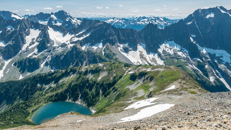
North Cascades, Washington
Another great option for glacier chasers who want to stick to the U.S. is the North Cascades National Park in northern Washington. In the truly wild landscape of the North Cascade mountains, glaciers abound: There are over 300 of them, the most in any area of the U.S. (outside of Alaska), though in 1980, that number was around 750. Many of the glaciers here have disappeared and continue to dwindle. The several remaining glaciers nevertheless have created an unruly shape on the mountains' peaks, which are full of sharp ledges, icefalls, and steep crevasses. Aside from being stunning landmarks, these glaciers are also crucial sources of water, providing about a quarter of the summer water supply for the region.
For travelers who want a scenic trip to glacial vistas without the strenuous climbs up to them, North Cascades National Park has a drivable solution. Running through the park is an iconic route that passes some of the Northwest's prettiest lakes and mountains: the North Cascades Highway. The highway connects all the way from Seattle, though the North Cascades portion is 30 miles and takes about an hour, cutting through the park's recognizable white-capped peaks with rest areas and overlooks along the way. The trails in the North Cascades are far from entry-level, but dedicated climbers have some solid options. The 3.7-mile Cascade Pass Trail is the park's most popular, and it's possible to extend the hike along the connecting Sahale Arm Trail, which leads to the Sahale Glacier and views out to Mount Rainier. Visitors can reach the park in a 1.5-hour drive from Bellingham International Airport, though the two-hour drive from Seattle-Tacoma International Airport is also doable if you're looking for more flight options.
Bernese Alps, Switzerland
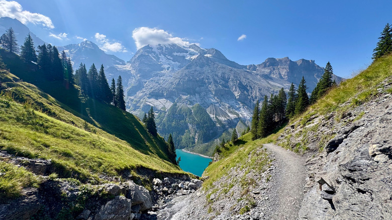
The Alps of Switzerland are glacial mountains through and through, but it's the Bernese Alps range that stands out the most for its majestic glaciers. It even encompasses a UNESCO World Natural Heritage Site, the Jungfrau-Aletsch protected area. The area is named after the Aletsch Glacier, the largest glacier across the Alps. Its reach spans about 50 miles, with its thickest ice going almost 3,000 feet deep, though it's losing around 160 feet of its coverage each year. The glaciers of the Jungfrau-Aletsch area have dazzled explorers, artists, and romantics for centuries, immortalized in paintings by J. M. W. Turner and Lord Byron's poem "Manfred on the Jungfrau." They're responsible for shaping the craggy peaks of mountains like Eiger and Mönch that appeal to experienced mountaineers for their legendary climbs.
Hiking through the Jungfrau-Aletsch area is possible and breathtaking, but requires special equipment (like crampons) or a guide. The Aletsch Panorama Trail, for example, is a three-day, 20-mile journey that crosses five heart-pounding suspension bridges, through meadows and mountain passes alike. The area caters to all kinds of visitors, though. Grindelwald's First Glider ride lets you fly atop the mountains in a hang glider setup that propels you down the First Mountain slope, with panoramic views of the Bernese Alps and their glaciers. The Jungfraujoch, an alpine saddle, is a popular entry point for reaching the glaciers of the Jungfrau-Aletsch area, whether you want to hike out to the Aletsch Glacier or just gaze out from its Sphinx observation building. The fastest way to reach Jungfraujoch is via Grindelwald: about a 40-minute train ride from the Interlaken Ost Station, followed by the Eiger Express gondola to Eiger Glacier station and one more train ride directly to Jungfraujoch, taking another 50 minutes.
Southern Andes, Argentina
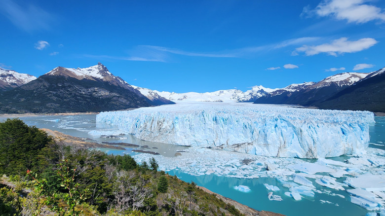
Sharply inclined pinnacles and turquoise lakes define the renowned image of Patagonia's Southern Andes mountains, and their unique appearance is owed to glaciers. The many glaciers here arise out of what remains of the Patagonian icefields — huge masses of glacial ice that cover the mountain range. In the southern portion of the icefield, in Argentina's Santa Cruz Province, you'll find the UNESCO-designated Los Glaciares National Park, which takes its very name from the massive, incredible glaciers that make up about half of its territory.
One of its biggest and one of the world's most famous glaciers is Perito Moreno, stretching over 18 miles long. Perito Moreno used to be considered a stable glacier, one that neither grew nor shrank. This quality has changed in recent years, as it's begun losing more ice than it gains, causing a net retreat. Along with other clustered glaciers, the Perito Moreno ends in Lake Argentino, where it sheds icebergs onto the milky-blue expanse for a spectacular sight.
Visitors can get to Los Glaciares National Park by flying into Comandante Armando Tola International Airport in El Calafate, with flights that connect from Buenos Aires. El Calafate, a small German-influenced town, is the best gateway to the Perito Moreno Glacier, with buses heading out from the El Calafate bus terminal directly to the glacier in about 1.5 hours. Ice treks across the expansive glacier are offered, or you could take a kayak out on Lake Argentino and paddle among drifting icebergs. Unless you visit in the winter, Perito Moreno can get crowded, but there are lots of other, lesser-known hikes around Los Glaciares National Park, too, including around the Upsala and Spegazzini glaciers.
Öræfajökull, Iceland
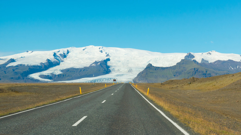
To describe Iceland's landscape as intense is an understatement. You'll rarely come across anywhere else in the world so stark and baffling, with frozen tides of glacier ice spilling down jagged, black volcanic rock. Iceland's biggest active volcano, Öræfajökull, is also part of the country's even larger Vatnajokull glacier, an enormous ice cap that blankets 8% of the country's land. The name Öræfajökull translates to "wasteland glacier," a nod to the desolate landscape surrounding the volcanic mountain after its devastating eruptions, though it's only erupted twice in recorded history. Glacial tongues extend from the rim of its ice-filled crater in a variety of forms — some smooth and crystalline, others forming steep, craggy peaks.
Most of the glaciers of Öræfajökull collide with the land right near the main road around the volcano, known as Iceland's Ring Road, which Rick Steves called "Europe's best road trip." It takes about four hours by car to reach the road around Öræfajökull from the Reykjavík Airport. Simply driving around the volcano gives you some incredible views of its massive glaciers, though there are unique ways to get up close. A good starting point is at the Jokulsarlon Glacier Lagoon, an iceberg-dotted lake fed by the Vatnajokull glacier, where you can take a guided boat trip or take pictures at Diamond Beach, marked by giant, shining chunks of iceberg resting on black, volcanic sand.
Hikers can park for free at Fjallsárlón Glacier Lagoon and then take on the four-hour hike up Fjallsárlón Glacier, one of the glacial tongues extending from Öræfajökull's crater. There are also stunning hikes available in Skaftafell, a wilderness area overlooked by Öræfajökull's peaks and home to the iconic Svartifoss waterfall that pours out from dark basalt columns.