South Carolina's Seven Natural Wonders Offer Centuries-Old Trees, Mountain Views, And Scenic Rivers
South Carolina is a fabulous destination for a vacation, but it's often overlooked. Visitors to the Palmetto State will find a charming island full of history, an underrated foodie town in the heart of the lowcountry, and some iconic cities and beaches. South Carolina is also home to some fine areas of unspoiled nature, places like the Mountain Bridge Wilderness Area, or the Francis Marion National Forest. And although they may not have the same gravitas as places like the Grand Canyon or Mount Everest, there are still places in this Southern state that could be considered natural wonders of the world.
The particular place we've chosen to highlight have been officially designated as South Carolina's seven natural wonders, a classification that hints at the awe that they elicit from visitors. They range in scope and environment, from winding rivers to vast forests and plains. Each promises travelers stunning outdoor realms, and the kind of encounter of nature that will nourish the soul, and forge lasting memories. In addition to these seven striking areas, we have added a couple more gems at the end.
ACE Basin
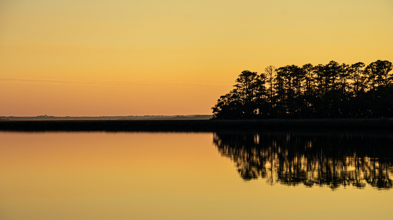
The "ACE Basin" are wetlands that got their name because they surround three rivers: Ashepoo, Combahee, and Edisto. The 350,000 acre area is an incredible, natural system (one of the largest areas on the Atlantic coast that's still untouched) of forest, marches, and barrier islands. The blog Kidding Around provides a handy summation of the wonder of this place. And despite it's natural beauty, the region is just a little over an hour from Charleston, a city with one of the world's most charming main streets. The various environments you can find there all seem to bleed into one another, creating a complex tapestry of terrain.
At one time, the ACE Basin was mostly rice plantations. There is also a former antebellum manor from the 1800s that currently serves as a visitor center. These days, a more common sight is that of migratory birds and lots of different types of flora. The ACE Basin National Estuarine Research Reserve safeguards almost 100,000 acres of the ACE Basin, protecting sturgeon, wood storks, and bald eagles.Within the larger area of the ACE Basin, visitors will find smaller segments to explore as well. For instance, the Botany Bay Plantation Heritage Preserve and Wildlife Management Area is sanctuary for turtles. Each year, up to 100 sea turtles nest there, and thousands of offspring crack open their shells and shuffle to the water. In addition, the Ernest F. Hollings ACE Basin National Wildlife Refuge is great for people that like to hike, fish, spot birds, and bike.
Bulls Island
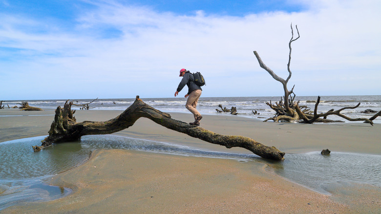
On a map, this wild coastal escape of untouched beaches and driftwood has a fragile appearance, almost like a dried, fractured leaf covered in tiny veins. Bulls Island is one piece of the Cape Romain National Wildlife Refuge, a clutch of barrier islands that unravel along more than 20 miles of the state's coastline. Visitors will find a wild array of ecosystems in the refuge, with ponds, forests, beaches, marshes, and a huge stock of channels where boats navigate. It is also a teeming center for bird life, with almost 300 species found on its lands, shores, and tidal zones. This is a realm of untouched wilds, set up in 1932 to protect migratory birds.
The tides push and pull through the creeks, feeding the marshes, the areas of wetland, the maritime forests. The environments contain species such as the red knot, the American oystercatcher, and the piping plover. White-tailed deer, and black fox squirrels shuttle between the trees, and the beaches are where to find nesting loggerhead sea turtles. The island also features shell mounds, a vestige of the Native Americans that once lived there.
Travelers can watch birds, scour the beaches for shells, hike the flats, or go on special tours. This includes a guided walk in the fall when visitors can even spot alligators. For photo buffs, another tour brings them onto the island's beaches to snap the sunrise. Other excursions allow guests to kayak around the waterways or learn about the island's history and geology with a local expert. To visit Bulls Island, travelers will need their own boat, or book a tour with Coastal Expeditions. Vessels depart from Awendaw, which is less than an hour's drive from Charleston, a gorgeous city that blends European appearance with Southern charm.
Chattooga River
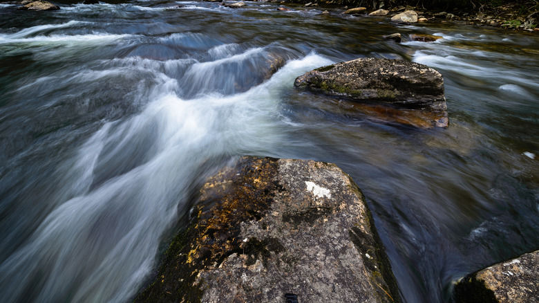
The Chatooga River is a magnet for whitewater rafters and flows through North Carolina, South Carolina, and Georgia. One past visitor on Google says, "When the river is flowing at normal or above normal stage you can see a wide range of rapids 1's and 2's for the beginners, or 3's-5's and above for the more advanced expert kayakers and rafters." The river's source is the Appalachians of North Carolina, where streams slowly come together to form a 57-mile-long river. As it descends a half mile in elevation, it finally disperses into Lake Tugaloo.
The Chatooga is completely free-flowing the whole way, with no dams, or facilities, or weirs. This makes the river feel very much like it has for centuries, and on either side of the waterway, visitors will see thick woods and riverbanks that are devoid of any kind of commercial development. Motorized crafts are also banned on the river, adding to the serene nature of a trip there. The river is one filled with character, at times peaceful and relaxing, while equally also a churning, roiling body of raging water, which is part of the appeal. It flows above and around giant rocks, down bubbling cascades, and forms deep pools flanked by high walls.
The comeliness of the landscape is hard to deny, with steep slopes blanketed in trees rapidly sliding down into tight gorges. Bends and curves along the river are constants, adding to the feeling of seclusion and mystery of this place. Travelers can also fish, hike on the riversides, and camp. In the fall, and the scenery will blaze in shades of yellow, orange, and red. Historic sites are also peppered along the river, including old homes and cemeteries.
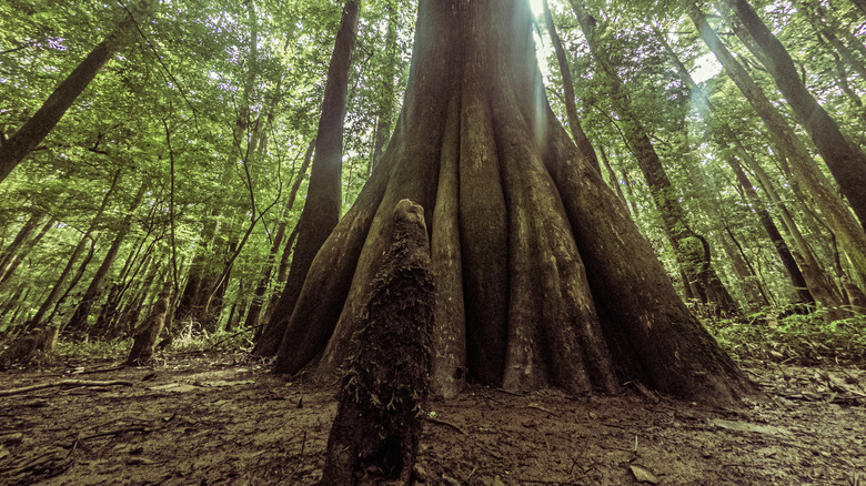
Congaree National Park
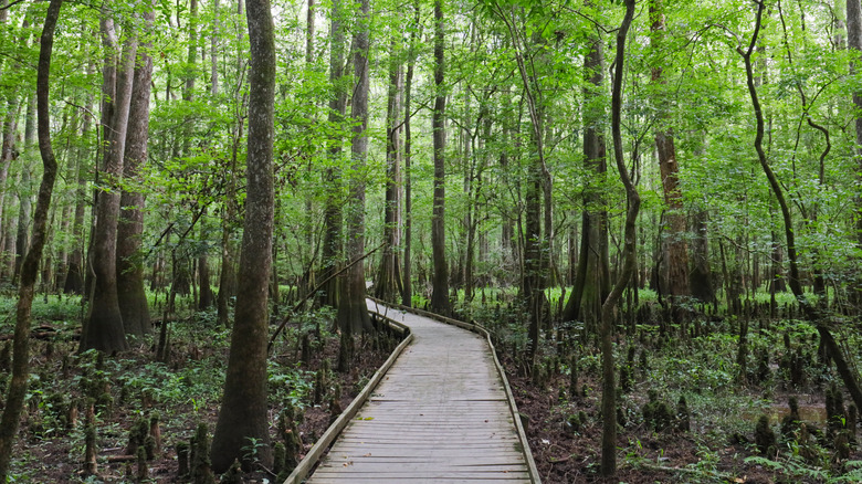
To wander among the huge tracts of hardwood forest of Congaree National Park is to enter a realm that seems almost mythical. Trees of various sizes blanket giant plains and flank winding rivers. This, in fact, is the biggest section of bottomland hardwood forest of original trees that still exists in this part of the country, making this national park even more unique. The Congaree and Wateree rivers weave their way among the floodplains, helping to feed and nurture plants and animals that make this forest their home.
Hikers of all experiences can choose from an assortment of trails that cut through the park. All trails are designed for walkers, and since much of the park is floodplain, the walks are typically level, with minimal ups and downs. Harry Hampton Visitor Center is the nexus for the trail network, and hikes radiate out from there, including a challenging one with great birdwatching.
On the Boardwalk Trail, an easy, wooden walkway starts on a bluff and then descends into the forest. Adventurers will come across loblolly pines, grand maples, and bald cypresses. A more taxing excursion is the Oakridge Trail, which rumbles along a ridge and takes in towering oak trees. You might spot wild turkey or deer while on this trail. The easy Firefly Trail, which is less than 2 miles long, showcases the synchronous fireflies that in the spring emit sparks of light in the forest. The national park is also a fantastic base for water sports, with canoe or kayak trips promising a rewarding way to spot alligators, otters, and turtles as you paddle along the 15-mile Cedar Creek Canoe Trail.
Edisto River
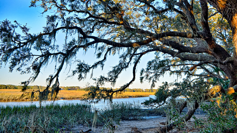
"Edisto River is such a relaxing peaceful place in nature to just be free from reality," points out a Google reviewer. What makes it even more remarkable, is that this is the longest, free-flowing blackwater river anywhere in the United States. Tranquility is the norm for visitors when they come to the Edisto River, which twists and bends northwest of Charleston. Its waters, with their earthy brown tint, are free from any kind of dams, and don't feature any churning rapids. It is a gentle, quietly flowing river with a relaxing current. So, for kayakers and canoeists looking for a pleasing excursion, the Edisto is a smart choice. It is also, in pure visual terms, a beautiful piece of nature.
Spring waters in the Sandhills, in the center of the state, are the source of the river, and from here it flows for hundreds of miles through plains and toward the ACE Basin. Along the route, the calm waters slide by huge oak trees, their limbs obscured by Spanish moss, and some of the oldest tupelo-cypress trees in the country. The highlight for any paddler is the Edisto River Canoe and Kayak Trail. More than 50 miles in length, it has camping and picnic sites along its side, and slices through the Colleton and Givhan's Ferry state parks. It also meanders its way through the Francis Beidler Forest, 15,000 acres of protected land that are actually a National Audubon Society Sanctuary, teeming with wildlife. Visitors will find beavers, kingfishers, redbreast sunfish, and wild turkey there. The river, however, has faced its share of threats. In 2015, it appeared on the list of the Top 10 most endangered rivers in America, with excessive withdrawal of its waters by agricultural enterprises causing real concern for its future. It hasn't been on the list since, but that warning was certainly a sign that this majestic waterway is not to be taken for granted.
Jocassee Gorges
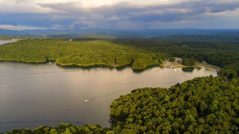
National Geographic once named Jocassee Gorges as one of its "50 of the World's Last Great Places" (via Discover South Carolina). This slice of Northwestern South Carolina is close to the borders of Georgia and North Carolina and provides visitors with plenty of rainforest and beautiful flora. There are more than 50,000 acres of protected area in all, with the aforementioned forests as well as lots of waterfalls — the most dense concentration of cascades in the eastern part of the country. This is thanks to not only the terrain around the region, but also the generous rainfall each year, with 75 inches of rain each year commonplace.
The wilderness area wraps around Lake Jocasse, a popular haunt for anglers up and down the country. For fans of flora, the Oconee bell flower, a bloom that only grows in Southern Appalachia, can be spotted in the gorges. There are also wildflowers, ferns, and lots of different types of wild mushroom. The healthy stock of fauna includes large numbers of black bears, and the most salamanders in the world. "Very peaceful," said one Google commenter. "The scenery here is absolutely breathtaking. If you're looking for a place to 'clear your head' and de-stress from everyday life for a little bit, then you should definitely take a drive out here."
Jocassee, in fact, translates to "Place of the Lost One," and in years past, the Cherokee people would hunt in the region. The scenery is certainly something to see, part of the Blue Ridge Escarpment, with mountains rapidly dropping to undulating hills. Throughout the slopes, rivers wind and merge, creating a number of gorges and waterfalls as they descend. This is where to find the highest waterfalls east of the Rockies — Whitewater Falls plummets more than 800 feet (though technically it is just over the border in North Carolina). Equally attractive is Lake Jocassee, 7,500 acres in size and jagged, and multi-limbed in shape. The reservoir was created by blocking a quartet of rivers, and is a huge draw for kayakers and divers, and also for anglers who seek to catch spotted bass and rainbow trout. Jocassee Gorges is also home to Sassafras Mountain, the tallest peak in South Carolina.
Sassafras Mountain
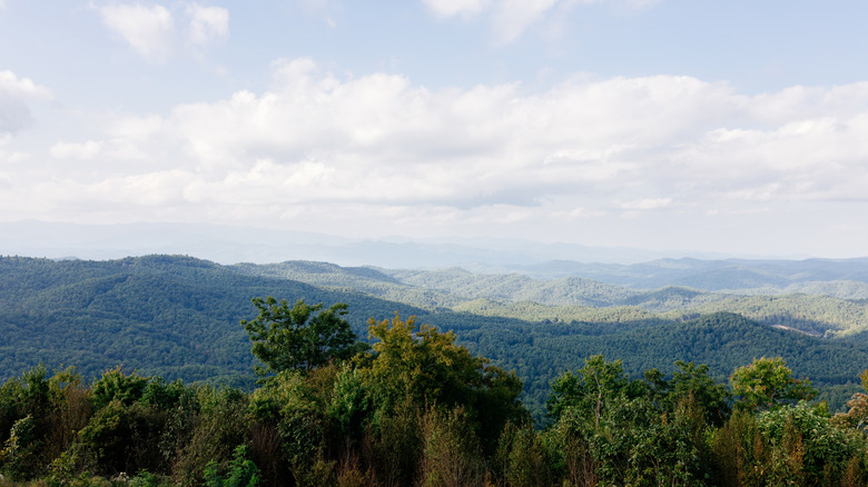
The views from the top of South Carolina's tallest peak are outstanding. "The tower at the top was built around 2019 and is a fun landmark," said a Tripadvisor contributor. "With curvy roads up to the top, this place has great views and is very picturesque. The tower lies on the border of the Carolinas but holds the tallest peak in South Carolina." This mountain is indeed the highest one in the state, topping out at 3,553 feet above sea level. It is one of the reasons the tourists come to the Jocassee Gorges, not just for the bragging rights, but also the wraparound views of the endless crests of the Blue Ridge Mountains in all directions.
The best vistas are from that tower, which is only about 10 feet higher than the top of the mountain, so it doesn't require a steep climb (it is also ADA accessible). From atop the circular platform, travelers will be able to look across into three states. There are even state lines marked on the top of the tower deck, so visitors can get a fun shot of themselves straddling North and South Carolina at once. Most visitors will make the trip up there by car, driving through tracts of white pine, but the more hardy can try a more testing option. The Foothills Trail bobbles along the Blue Ridge Escarpment for almost 80 miles, cutting through woods en-route, and leads to the peak.
Bonus: Angel Oak
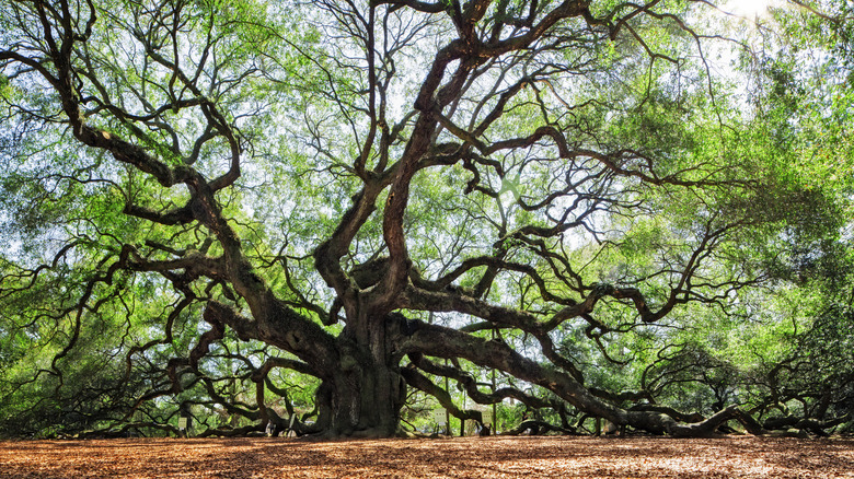
For more memorable photos, this ancient tree handsomely fits the bill. The gnarled tree is hundreds of years old, its limbs reaching and turning like bent appendages that are trying to straighten and break free. The sight really is a delight for photographers, but even fans of the wonders of nature will be amazed at the scene. "This is a must-see if you're in the area. It's a moment of pure wonder and awe, looking at all the detail," a past visitor wrote on Tripadvisor. "The size is astounding let alone all its branches and the way they bend and turn."
There are no official statistics to definitively date the age of the tree, but some sources suggest it is about 400 years old, or a little more. What is known is that it is 65 feet upright, has a trunk that has a waist size of about 25 feet, and it is the largest live oak east of the Mississippi River. Its longest branch is about 190 feet, from end to end, and the tree's vast web of branches provides shade covering 17,000 square feet. The oak stands on Johns Island, only about half an hour's drive southwest of Charleston.
Bonus: Table Rock Mountain
Table Rock Mountain is a peak that sits in what was formerly Lower Cherokee Nation — now within Table Rock State Park. For outdoorsy travelers, this is a beautiful spot is rife with adventure since the ares spreads across the foothills of the Blue Ridge Mountains. "Having visited this park many times, my wife and I still look forward to staying in a park cabin and hiking some of the awesome trails on and around the mountain," said one past visitor on Tripadvisor. "The cabins are spotless, well-maintained, and very comfortable, and they are situated within easy walking distance of the trailheads."
There are trails all around the park, and during certain times of the year, they promise the glorious colors associated with changing leaves. On the Pinnacle Mountain Trail, hikers will get a fine view of Table Rock Mountain. There is also a hike to the mountain itself, about 4 miles each way from the Visitor Center. The park is also a place where travelers can catch the Foothills Trail to Sassafras Mountain.