We Ranked The 5 Best Waterfall Hiking Trails In Oregon
By some counts, Oregon is the state with the most overall waterfalls in America. There are hundreds upon hundreds of cascades to see in this land of cloud-splintering volcanoes and ancient rainforests, including some that will have your jaw hitting the proverbial floor. Yep, Oregon hosts the 97-foot-high Tumalo Falls, a gem within a national forest, strange coastal waterfalls that pour into the Pacific, and even the so-called "Highway Of Waterfalls" through an ultra-scenic river valley.
But waterfalls aren't always the easiest natural wonder to find. They tuck away in woodlands, along roaring rivers, in gorges, and on the slopes of mountains. You often have to hike to reach them, which is where this guide comes in. Taking inspiration from leading travel blogs and publications, it lists five of the finest waterfall hiking trails in Oregon.
There are some real doozies in the mix, including a route that takes you right to the top of the tallest falls in the state, and another that goes over petrified lava fields to a waterfall deep in an old-growth forest. The good news is that many of the state's falls are in action year-round, though spring tends to see the strongest flows thanks to added snowmelt and rain.
Multnomah Falls
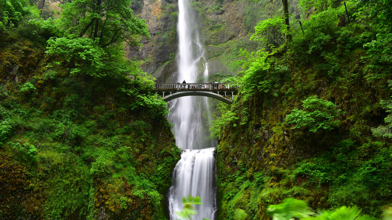
The waterfall that got the joint-highest number of mentions across travel blogs was the great giant that is the ethereal, year-round destination of the Multnomah Falls. This is the tallest in the whole of the Beaver State, clocking up an awesome 620 feet across two tiers as it flows through the wonderfully lush landscapes of the Columbia River Gorge, some 30 miles east of downtown Portland.
Getting there isn't hard. There are now regular shuttle buses that run through the so-called "Waterfall Corridor" beside the Columbia River, passing by a whole medley of cataracts before hitting the major cascades at Multnomah. They're a good choice for summer visits, since there's now a timed permit system in operation between May and September for folks visiting in their own vehicle.
When it comes to hiking, there's a bit of a sliding scale of difficulty. You can opt for an easy-going paved path to the lower viewing area, which is fully accessible to wheelchair users. Alternatively, there's a 2.4-mile out-and-back route with 800 feet of elevation. It whisks you right to the top of the upper section of the falls on thigh-burning switchbacks, eventually topping out at a precipitous viewing deck where you can feel the raw power of the water as it drops over the edge.
Trail of Ten Falls
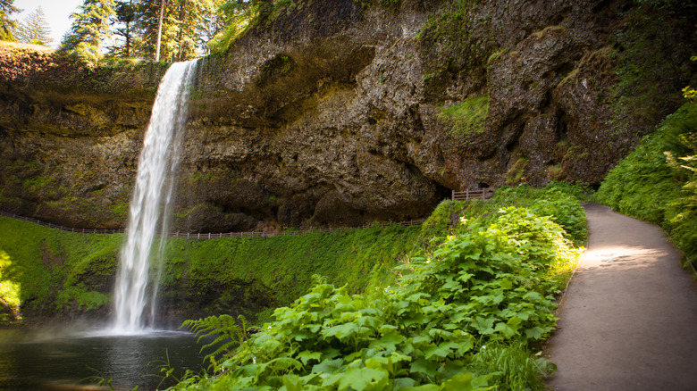
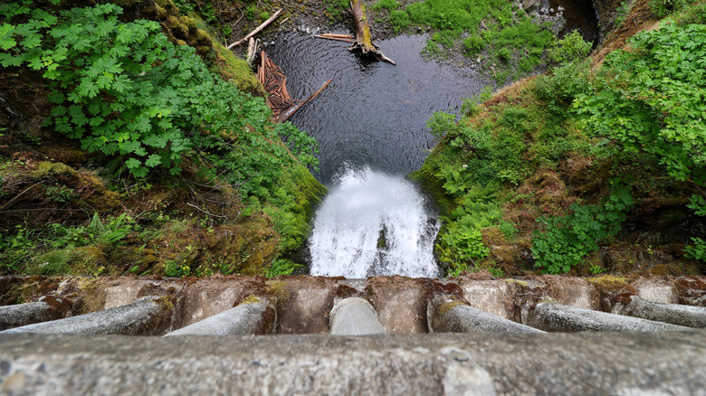
As the name implies, there are 10 good reasons why this particular hiking route deserves to be on this list. Over the course of 7.6 miles, you'll go on a veritable waterfall odyssey through Silver Falls State Park, scaling falls, gazing up at falls, and even ducking underneath them! Needless to say, plaudits abound for the route. Not only did it receive six recommendations across our source blogs, but Chris and Frankie of Waterfallz.com, a whole travel blog focused on waterfall hiking, hail it as the finest waterfall hike they've ever done!
The Trail of Ten Falls is a loop that begins at the South Falls Day Use Area off Highway 214, just shy of 40 minutes east of Salem, OR. It's possible to complete the loop in either direction, though, according to past hikers on Reddit, heading counter-clockwise means you'll dodge some of the crowds and finish the short, less-impressive road section right away.
The path starts by going through meadows and alongside a creek before opening up to a view of the Winter Falls, the smallest on the hike. You'll cross a few bridges after that and pick your way through dense forests of soaring pines and firs, occasionally happening upon another majestic waterfall deep in the woods. The overall highlight is surely the 177-foot wall of water that is South Falls, where the trail weaves behind the cascade for a unique experience.
Proxy Falls Loop
The trailhead for the Proxy Falls Loop sits neatly amid the bright blue lakes and snow-capped volcanoes of the McKenzie Pass-Santiam Pass Scenic Byway, deep in the woods and wilds of the Willamette National Forest. Now, if that sounds like a tempting location for a waterfall hike, then that's because it really, really is. Over 1,600 past hikers have scored this loop 4.8 out of 5 on the global adventure app AllTrails, a 4.9 out of 5 on Google, and a staggering six separate blog posts mentioned it as one of the absolute best waterfall hiking routes in the whole Beaver State.
Across 1.7 miles of walking, you'll see all sorts of flora and fauna. There are ancient frozen lava fields, maple forests, and great sweeps of emerald-green firs to get through as you hike over gnarled roots and clusters of volcanic rock. There's an offshoot of the main trail that will take you down to the base of the lower section of the falls, a dramatic spot where the water is framed by the collapsed trunks of huge trees. Keep going to get to the higher section, where the water filters through the forests into a super-still plunge pool.
Just be warned that the winding Highway 242, the main access road to the start of the Proxy Falls Loop, often closes completely in the winter when heavy snowfall hits the Cascades. You'll also have to pay a small day-use fee to park at the designated lots. April and May are considered excellent times for waterfall viewing here, while autumn can be spectacular as the woods start to change color.
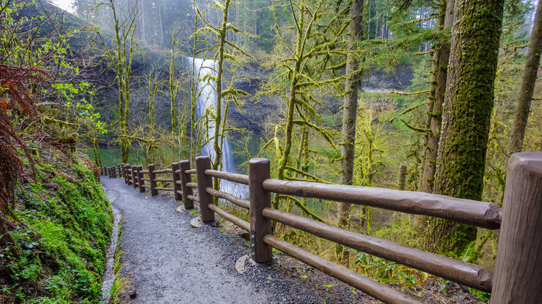
Latourell Falls Loop
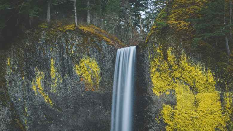
Another of the many waterfalls that pepper the south side of the Columbia River Gorge, Latourell Falls is among the closest of all the options on this list to big old Portland. A drive of just a touch over 30 minutes will help you swap the abundant craft beer breweries of the city for the sounds of rushing water in the forest. There's free parking on offer right by the trailhead, but it can fill up fast in the peak summer months, so early arrivals are key.
The main hike here is a loop that goes past both tiers of the waterfall itself. It comes super-highly praised — think 4.8 out of 5 on AllTrails with upwards of 10,500 reviews from past hikers. But you don't have to do the whole 2.1 miles to get great views. In fact, you can veer right at the parking lot to access a super-short trail that almost instantly throws out views of the lower part of the falls, an impressive 224-foot-high cascade that trickles over a craggy rock.
Meanwhile, WTA.org, the official website of the Washington Trails Association, suggests a longer romp of about 3 miles on steep, zigzag paths cutting through the woods. Your reward is the secretive enclave of the upper section of Latourell Falls, a secluded little cascade that's carved out a nook in the basalt cliffs.
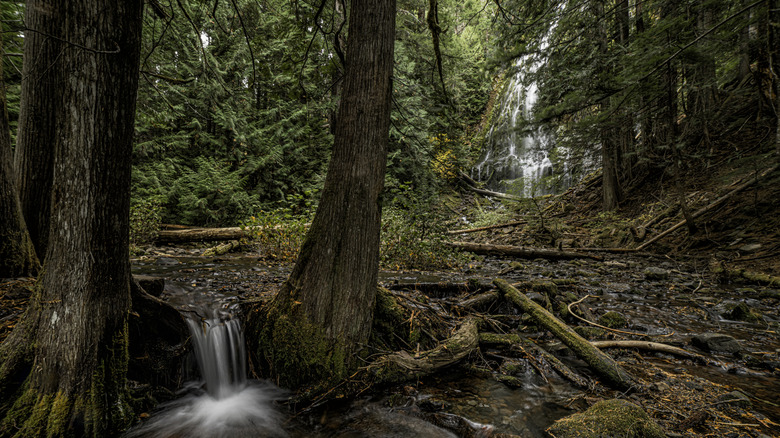
Toketee Falls Trail
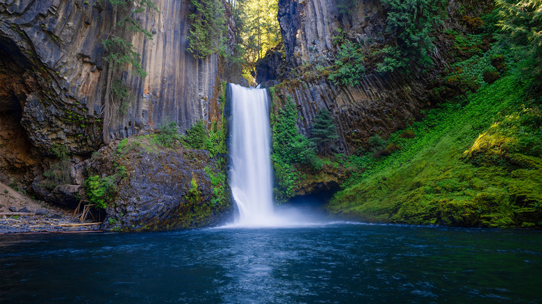
At the time of writing, nearly 3,200 past hikers have given the Toketee Falls Trail a combined review score of 4.7 out of 5 on AllTrails, with one writing: "This is a beautiful 'don't miss it' trail that you should visit in Oregon!" Our research seems to agree — there were five mentions for this route across various publications, which put it tied with Latourell Falls Loop for a spot on our list.
It's not a strenuous hike by any stretch of the imagination. The whole thing from start to finish is just 0.8 miles and clocks in with a rather lackadaisical 120 feet of elevation gain. The trail begins by weaving through stands of huge western red cedars and Douglas-firs right beside the North Umpqua River, passing pools of inky water and little stretches of rapids.
The grand finale is a timber-built lookout station that's uniquely constructed around the trunk of a huge evergreen tree. It soars some 70 feet above the roaring waters below, offering head-on views of the cascade and its chiseled frame of basalt rock. Stand there, take it all in, and get a feel for why Toketee Falls is one of Oregon's most beloved waterfalls.
Methodology
The selection above is comprised of the hiking trails that got the most mentions across six separate travel blogs and travel publications, all of which sat on the first page of Google and dealt directly with recommendations of the top waterfall hikes in the Beaver State. We awarded a point every time a particular waterfall hiking route got a mention, and then ranked them accordingly — the hikes with the most mentions went to the top of our list; the ones with fewer went towards the bottom. Reviews on AllTrails and Google were also referenced to confirm their popularity.