Arizona's 11 Most Historic And Geologically Stunning National Monuments
Arizona is home to dozens of federally recognized parks, historic sites, recreation areas, and trails, a whopping 19 of which fall into the category of national monuments. Thirteen are managed by the National Park Service, while the other six fall under the jurisdiction of the Bureau of Land Management. Some have been recognized formally for more than a century, while others, like the Grand Canyon-Parashant National Monument and Baaj Nwaavjo I'tah Kukveni-Ancestral Footprints of the Grand Canyon, have been designated in just the past few decades. And while striking desert landscapes and cultural treasures abound in all of the state's parks, there are some true standouts for those who are fascinated by American Indigenous heritage and spectacular geology, which often go hand in hand in this diverse region.
From the reconstructed 12th-century pueblo of Wupatki National Monument to the dramatically balanced rock pinnacles of Chiricahua National Monument, Arizona boasts a wide array of deeply historic and culturally significant sites that are ideal for day trips from major cities or longer overnight stays. Traverse volcanic landscapes, ancient communities, and delicate desert ecosystems, and enjoy a range of outdoor recreation opportunities — not to mention great photo ops along scenic drives.
We've tapped into the author's experience visiting most of these parks, plus NPS.gov, BLM.gov, Arizona tourism resources, blogs, and visitor reviews to share the most impressive and memorable monuments in the region. Far from an exhaustive list, the roundup below can be a great way to get the itinerary-building wheels turning and help you plan your next road trip through red rocks, canyons, mountain roads, and forests.
Grand Canyon-Parashant (near Littlefield)
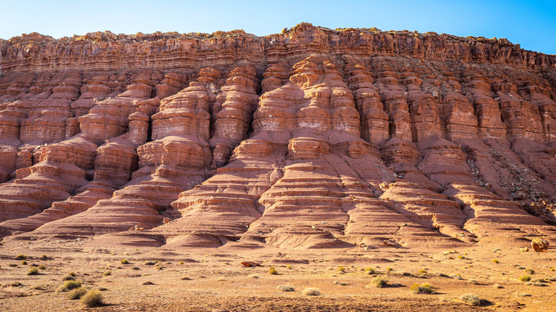
Located at the northwest edge of the Grand Canyon, bordering the national park's eastern and southern sides, Grand Canyon-Parashant National Monument — often referred to simply as Parashant — is a spectacular extension of this canyonland with thousands of years of Indigenous cultural history. Its undeveloped expanse, one of the American Southwest's "last truly wild" places, is also geologically and biologically diverse, with rocks dating back almost two billion years. Nearly a third of it is wilderness, and the rest of it is grazed by several thousand cattle through lease agreements with local ranchers. It's also one of the most remote places in the contiguous U.S., meaning amazingly dark skies, quiet roads, and plenty of wildlife.
There are numerous ways to enjoy Parashant, including scenic drives along hundreds of miles of backcountry roads. High-clearance 4x4 vehicles are highly recommended for most routes, which are dirt and may become rutted or muddy depending on the conditions. You probably can't stress enough the importance of making sure you have a full tank of gas when setting out. The most popular drive takes you around the Mount Trumbull Scenic Loop, where you can step into a historic one-room schoolhouse, pass a former sawmill site, and look for petroglyphs at the Nampawheap archaeological site. While there aren't any developed campgrounds in the park, backcountry camping is a great way to experience solitude in nature.
Canyon de Chelly (near Chinle)
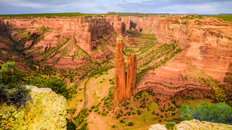
While Canyon de Chelly (pronounced "canyon deh shay") has been recognized as a national monument since 1931, its history goes much further back, as it's been inhabited and traversed by people for at least 5,000 years. The Navajo, who call themselves Diné, know this place as Tsegi or Tséyi' (pronounced "say-yee"), which means "rock canyon," and they continue to live and herd livestock here today. Entirely located within Navajo Nation, the National Park Service partners with the local community to make this revered place a destination for all.
One of the most sacred sites in the monument is called Tse Yaa Kin, which dates to between A.D. 300 and 1300 and is known to archaeologists as the "Mummy Cave" due to the discovery of wrapped human remains. To the Diné, it is holy ground. While the site is normally off-limits to visitors, it gives an impression of the power this area has held for thousands of years.
Tourists can drive along the monument's two paved roads to take in the views from overlooks, and private tours organized in advance with local companies can guide you into the canyon. Park rangers lead free programs during the summer from the welcome center — there's actually no entrance fee to the monument either — and if you plan to stay a day or two, the year-round Tséyi' Diné Heritage Cottonwood Campground is surrounded by beautiful scenery.
Navajo (near Shonto)
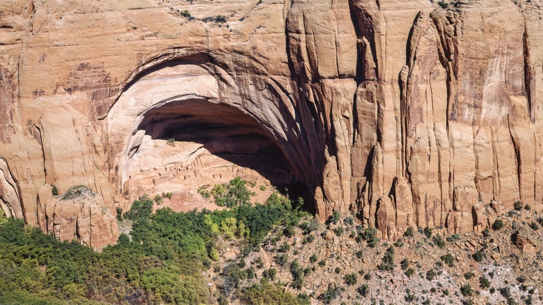
Cliff dwellings, hiking trails, and beautiful canyons characterize the incredible Navajo National Monument, which, like many in the northern Arizona region, sits in the Navajo Nation and is managed in cooperation with the National Park Service. There's no entrance fee, and from the visitor center, a trio of relatively short trails leads to scenic overlooks. "There are great views from the back of the visitor center if you don't want to hike," shares a visitor on Tripadvisor.
The main spectacle is a cliff dwelling called Betatakin, which sits in its namesake canyon beneath a naturally eroded sandstone overhang. See it from above at the end of the Sandal Trail, which is relatively short but has some steep sections, or join a ranger-led hike into the canyon during the summer months to visit it up close. The walk is challenging, as the descent and ascent in a very dry climate can take people by surprise. But if you're up for an adventure, it's a truly magnificent example of an Ancient Puebloan village that last saw residents around A.D. 1300.
There are two additional cliff dwelling sites in the monument: Keet Seel and Inscription House. The latter isn't open to the public due to its remoteness and fragile state, but Keet Seel is sometimes visitable through special overnight guided expeditions, typically in the spring and fall. For an easy overnight, book a site at either Sunset View or Canyon View Campgrounds, the latter of which is open during the summer and the former all year-round.
Vermilion Cliffs (Marble Canyon)
Overseen by the Bureau of Land Management, Vermilion Cliffs National Monument is an unforgettable sight in northern Arizona just west of Page, the under-the-radar gateway to Lake Powell and Antelope Canyon. In a similar vein to Parashant, despite being about a quarter of the size at about 280,000 acres, remoteness is the key word here, as there are no paved roads. If you want the whirlwind preview or you're not driving a high-clearance 4x4 vehicle, drive along U.S. Highway 89A between Jacob Lake and Marble Canyon, and you'll be accompanied by towering, glowing cliffs the whole way. If you are equipped to take on backcountry dirt roads, Paria Canyon-Vermilion Cliffs Wilderness, which is encompassed by the national monument, is where things start to get really interesting.
Vermilion Cliffs' most famous and sought-after feature is Coyote Buttes, which includes an area fondly known as "The Wave" in Coyote Buttes North. A permit is required to visit here, as a limited number of people are permitted to wander through it per day. Permits are acquired via a highly competitive lottery, which you can apply for four months in advance or try your luck the day before you'd like to visit (from a mobile device only). Even if you don't win a permit via The Wave lottery, you can still hike around the otherworldly White Pocket area, take a backcountry trek into Paria Canyon (a permit is required for overnight trips), or camp just outside the monument at one of two developed campgrounds. Stateline Campground is toward the north, aptly situated near the Utah state line, and White House Campground is south of Highway 89A.
Chiricahua (near Willcox)
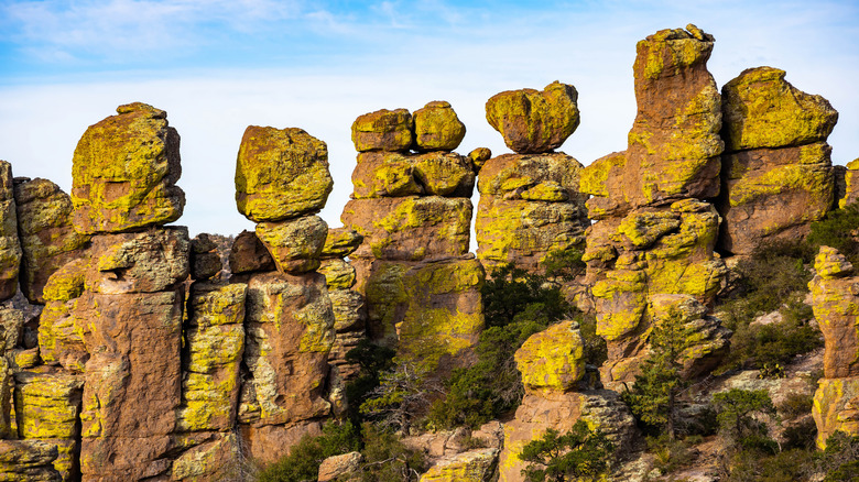
If the National Park Service's description of Chiricahua National Monument as a "wonderland of rocks" isn't enough to sway you to check it out, then go for the scenic hiking trails and stargazing sites. The area is known for its volcanic landscapes, and here in southeastern Arizona's Chiricahua Mountains, you'll find amazing pinnacles and balanced rocks. There are about 17 miles of hiking trails throughout the park, which are the best way to get up close to some of the most interesting geological formations, such as the Echo Canyon Grottoes. Birdwatching and wildlife-spotting are also ideal along Bonita Creek, overlooked by dramatic cliffs.
A stop at the visitor center is the best way to orient yourself to this stunning landscape, where you can watch a film, explore exhibits, and visit the shop. The building is a great example of early 20th-century Civilian Conservation Corps design, and the paved highway through the park is also thanks to this initiative in the mid-1930s. Massai Point is one of the park's most popular spots, accessible along a paved scenic road. The historic Faraway Ranch is also a worthy place to explore and stop for a picnic, where a Swedish immigrant family settled and gradually expanded a two-room cabin into a farmhouse, and then an inn. For your own place to stay, reserve a site at Bonita Canyon Campground, which is ideal for tents and small campers. Sleep beneath the canopy of trees with towering cliffs all around.
Sunset Crater Volcano (near Flagstaff)
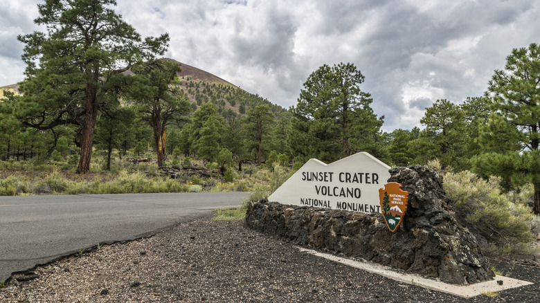
Sunset Crater Volcano National Monument sits 20 miles north of downtown Flagstaff, the world's first International Dark Sky city, where a giant cinder cone volcano rose up very quickly around 1,000 years ago and erupted for possibly only a few months around A.D. 1085. Not only is this a geologically fascinating area, but there are also wonderful archaeological examples of Indigenous American communities that were thriving around this time. And while Sunset Crater — which describes the depression on the top of the cone and its reddish, oxidized color — is no longer active, it's part of a large system that is. That said, we probably won't experience another major eruption for several thousand years.
This national monument is filled with beautiful ponderosa pines and views of the spectacular cinder cone, which you can drive right along the base of on Loop Road. Stop at the visitor center to watch a short film about the area's geological and cultural history, then set out on a walk along one of the park's relatively short trails to see lava flows and the unique ecology of a landscape that has spent centuries coming back to life. The fittingly named Lava Flow Trail is ideal for those with strollers, wheelchairs, or pets, as it's paved and provides great views of both the volcano and its ancient basalt stream. And if you'd like to stay awhile, the U.S. Forest Service manages the seasonal, tree-lined Bonita Campground, which is conveniently located across from the visitor center.
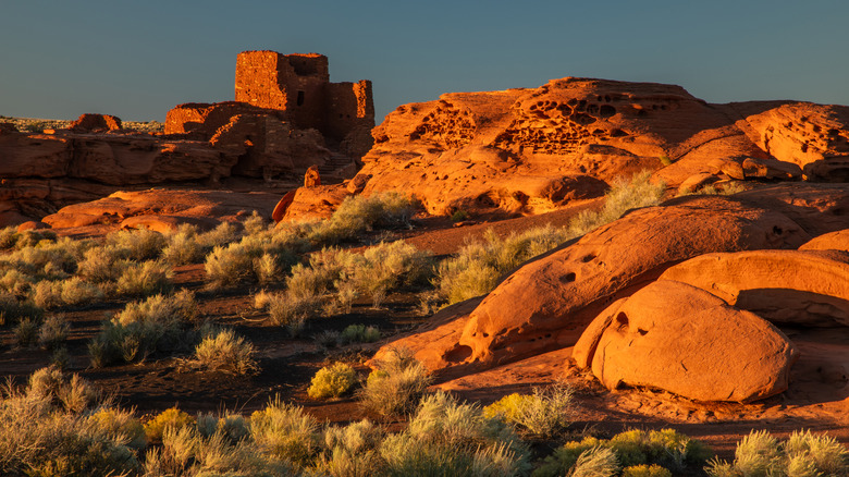
Wupatki (near Flagstaff)
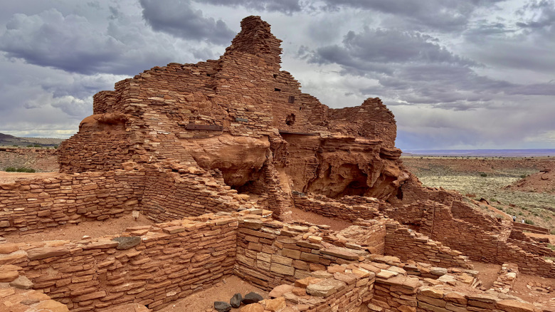
Just north of Sunset Crater and connected via the Loop Road, Wupatki National Monument is a striking example of an Ancestral Puebloan community at the edge of the incredible Painted Desert of northern Arizona. For those interested in ancient Indigenous heritage, it's hard to beat a place of this stature. The property is focused on a giant pueblo structure that was built and inhabited around the 1100s following the eruption of the nearby cinder cone volcano. It's a truly fascinating example of Indigenous village architecture, with 104 rooms, a ball court, and a so-called geographical "blowhole" in the earth, which likely had deeply spiritual significance and may have provided warnings of changing weather. Much of Wupatki was reconstructed following excavations in the early 20th century, but some areas remain as they were found, leaving plenty of fodder for the imagination.
Visitors can walk around the main structure on a path, taking in the expansive and virtually uninterrupted landscape all around, and a guided point-by-point factual brochure is available for purchase in the visitor center. Additionally, smaller dwellings are perched atop canyons and amid rolling hills in other parts of the park, including the Lomaki and Box Canyon pueblos, the impressive 3-story Wukoki Pueblo, and the Citadel and Nalakihu Pueblos, all of which can be reached via relatively short hiking trails from the road. "If you take your time and walk to the sites, then I'd plan on several hours to see everything," shares a visitor on Tripadvisor. "I'd also recommend bringing a pair of binoculars to see things you can't drive to or walk to."
Walnut Canyon (near Flagstaff)
About a 15-minute drive east of Flagstaff, just off I-40, Walnut Canyon National Monument is centered amid its namesake gorge. The relatively small but deep, lush, and winding canyon was an ideal place for Indigenous people to make their homes, building small cliff dwellings amid the sedimentary limestone and sandstone, often looking across the canyon to their neighbors. If you happen to visit in March, which can be a comfortably cool time to visit with average highs around 50 degrees, Flagstaff Area National Monuments celebrates Arizona Archaeology and Heritage Awareness Month with lectures, guided walks, and kids' activities. Throughout Arizona's parks, events, and learning opportunities during this time are a great way to get a deeper insight into the region's human stories.
The main feature of the park is a 1-mile loop called the Island Trail, which allows visitors to walk near and occasionally into more than two dozen rooms in stone dwellings, some of which still have their wooden lintels over the doorways preserved in place. The walk does require quite a few stairs — 736 to be exact — but for those willing to head down into this unique, ancient community, it's a rare chance to get up close and personal with this area's centuries-old history. For an easier, more accessible walk, head out on the .7-mile out-and-back Rim Trail.
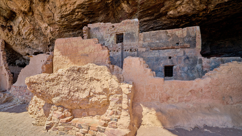
Montezuma Castle (near Camp Verde)
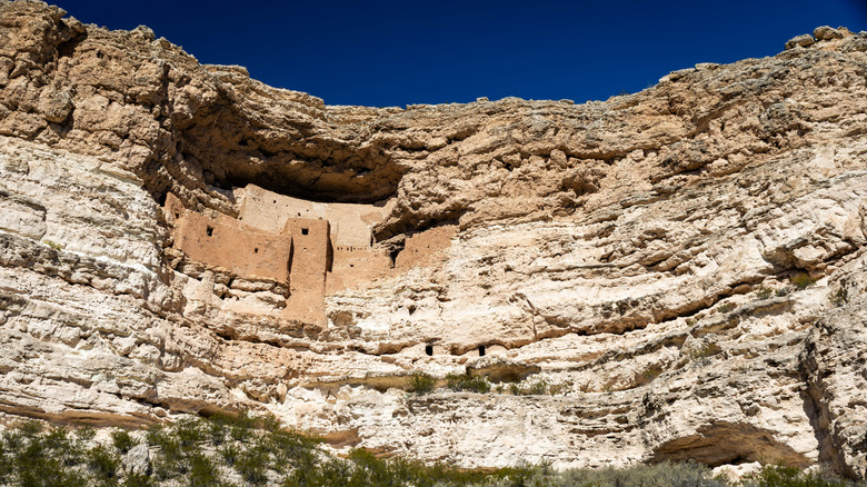
Along the lines of one of the most underrated national parks in Colorado, the cliff dwellings present in many of Arizona's national monuments are spectacular glimpses of historic cultures that the desert has preserved for centuries. Montezuma Castle National Monument is yet another well worth a visit, centered predominantly around a 5-story, 20-room "high-rise apartment" built high up on a dramatic cliff, inside a natural niche. Like others in the region, it's hundreds of years old, and it's visible from an easy loop trail that's about a third of a mile long. While the actual stone structure is not open to the public to visit directly, during the summer you can join a daily ranger talk at the nearby amphitheater to learn more about the site's history and the people who lived here.
There are actually two units of Montezuma Castle National Monument, the second of which is known as Montezuma Well and is about 11 miles away from the main attraction. You'll find additional cliff dwellings constructed along the rim of the limestone sinkhole, which is filled with water from a natural spring. Explore remnants of its more recent past as an independently run tourist attraction before it became part of the National Park System in 1947.
Tuzigoot (near Clarkdale)
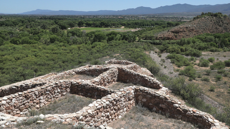
A huge hilltop stone village marks the key feature of Tuzigoot National Monument, which just ekes out ahead of Wupatki Pueblo in terms of size, with about 110 rooms. It's also only a half-hour drive southeast of Montezuma Castle, and one entrance fee covers both if you visit them within a 7-day period. At the visitor center, explore the museum, which is home to a collection of more than 3,000 artifacts and exhibits about what life was like here 1,000 years ago or more. The building itself was completed in 1936 and is a fantastic example of National Park Service architecture from that era — an artifact unto itself. The trail to the pueblo departs from the visitor center and takes you in a loop around the structure for about 0.3 mile, with the opportunity to step inside one of the rooms.
You can also extend your visit with a wander around Tavasci Marsh, which sits just a little bit to the northeast of the pueblo. The river is what sustained the village here a millennium ago, and it continues as a home for more than 270 bird species and dozens of kinds of mammals and amphibians. "[The park] is very easy to get to, well maintained paths, and a great visitor center with ample bathrooms," shares a visitor on Tripadvisor.
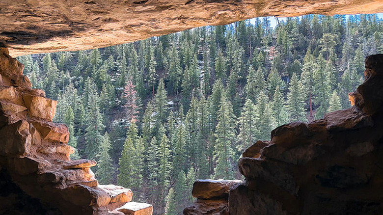
Tonto (near Roosevelt)
Just south of the expansive Theodore Roosevelt Lake in the Sonoran Desert, amazing cliff dwellings are preserved at Tonto National Monument that date to around 700 years ago. "There is a special feel to the place even though the ruin itself is minimal," shares a visitor in a review on Tripadvisor, adding: "Really nice picnic tables near the entrance where you can have lunch with an excellent view." Head out on a 1-mile round-trip trail to the Lower Cliff Dwelling, where you can take in beautiful views of the lake in the distance and walk inside parts of the structure. This is a great way to enjoy Tonto on a self-guided basis, but there's an even more immersive way to enjoy a visit.
If you have a bit of time and can plan ahead, the Upper Cliff Dwelling is reachable by way of ranger-guided tours, which are available on weekends between January and May and can be reserved in advance starting the prior autumn. It's about a 3-mile round-trip walk, and a tour takes about four hours. The landscape is dotted with saguaro cacti and other beautiful desert plants, and it's a great place to get an elevated view of the Tonto Basin. And while there's no campground within the national monument, the surrounding Tonto National Forest has campgrounds operated by the U.S. Forest Service. Windy Hill is one of the closest, perched right on the edge of Theodore Roosevelt Lake, and Burnt Corral is located on Apache Lake to the west, one of the most underrated lake destinations in the Southwest.