
8 Of The Most Underrated National Parks And Monuments In The Pacific Northwest
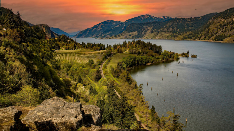
The Pacific Northwest is home to an unforgettable variety of landscapes. Ancient forests so dense that daylight barely reaches the ground, volcanic peaks wrapped tightly with glaciers, a coastline immersed in raw, windswept beauty. Washington, Oregon, and Idaho are the three states widely recognized as the PNW, and together they form one of the most scenic and ecologically extraordinary regions in the United States. Olympic, Mount Rainier, and Crater Lake are the big three when it comes to national parks and monuments here. Nearly 3.6 million visited Olympic in 2025, while Mount Rainer had 2.4 million visitors. Crater Lake saw a more modest — but still impressive — 630,000 guests. Exploring all three gives you access to sights like the ancient Hoh Rainforest, the iconic summit of Mount Rainier, and the supernatural color and stillness of Crater Lake. They are spectacular, and they deserve every visitor they get. But these three parks are not the end of the story.
Beyond them are quieter, less-visited parks and monuments just as deserving of attention. They are underrated treasures that offer everything from dark skies and underground worlds to ancient ecosystems and geological wonders. Many are underrated simply because they don't carry one of those famous names; others sit within national forests without their own standalone boundaries. Some even ask a little more from those who want to find them.
We've consulted everything from local outlets like the Washington Trails Association and OregonLive to national publications such as National Geographic and the Nature Conservancy to put this list together. We also sought ground-level advice from travelers on forums like Reddit, where hikers and outdoor enthusiasts have shared their experiences. Every site we came up with was consistently identified as underrated across multiple sources. Here are those eight underrated PNW national parks and monuments.
North Cascades National Park, Washington
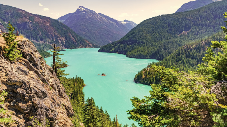
Europe may well have the Alps, but the Pacific Northwest has the North Cascades. The "North American Alps" is what they call the North Cascades Range, but only 46,925 visitors showed up to the North Cascades National Park in 2025. For a park of its scale and beauty, that's almost insulting. North Cascades National Park is a 504,960-acre park where cathedral peaks rise in every direction, glaciers sprawl across ridge lines, and meadows erupt in wildflowers every summer.
You'll find the park in northwestern Washington — and at around 2.5 hours from Seattle, it's close enough for a day trip. But most who arrive treat the North Cascades Highway as the destination rather than just the way in. That's mainly down to Diablo Lake, a popular stop for capturing Instagram moments. It's little wonder travelers choose this spot. The lake is a deep, almost electric green color, and it's hemmed in by dark forest and snow-dusted peaks for an almost surreal scene. But while the highway is the main access point, don't plan on driving it in winter — it's one of the world's snowiest places, and it will be closed.
There's little road access beyond the highway, but there are over 400 miles of trails pushing deep into the park. Kayaking, canoeing, and rafting are all available on the rivers and lakes throughout, too. As you explore, there will be opportunities to see some of the 300 or so glaciers that cling to the mountainsides here. In fact, the North Cascades are home to more glaciers than anywhere else in the lower 48. However, they've been receding since the late 19th century and might not be around much longer, with one of the range's last major glaciers, the Columbia Glacier, estimated to be gone by around 2050. With that in mind, now is a good time to see this natural wonder!
Mount St. Helens National Volcanic Monument, Washington
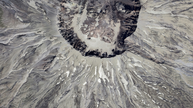
On May 18, 1980, America's most violent volcanic event occurred. Triggered by a 5.1 magnitude earthquake and a subsequent landslide, a wall of superheated gas and debris blew the top off Mount St. Helens. It obliterated almost 150,000 acres of the surrounding landscape and, tragically, killed 57 people. In fact, almost nothing survived the blast. The monument has been largely left alone since. There has been no replanting and no intervention of any sort — and what has happened is nothing short of remarkable. Spirit Lake, just north of the volcano, was buried under rock and ash when the mountaintop blew, but it emerged from the devastation. You can still see the trees that were blown into the lake floating on the surface, but the forest is growing back on the surrounding slopes, and the elk have returned.
The 110,000-acre national volcanic monument sits in southwest Washington within the Gifford Pinchot National Forest. It was established just a couple of years after the blast, and the main entrance sits off State Route 504. From there, you can hike to the crater rim. It's just as dangerous as it is breathtaking. You'll need a permit, but it doesn't require technical skills or specialist equipment. You can also hike through Ape Cave, one of the largest lava tubes in North America, or kayak the clear mountain lakes nearby. If you seek something more intense, the blast zone has trails for mountain bikers unlike anything else in the region. Yet even with all these activities and sights and the fact that it's accessible year-round, Mount St. Helens still pulls in significantly fewer visitors than nearby Mount Rainier.
Oregon Caves National Monument, Oregon
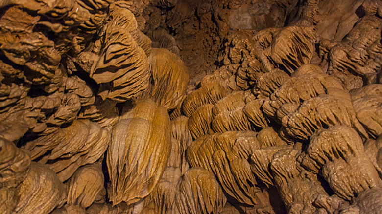
When you visit just about any cave in the National Park System, it's dissolved limestone you're walking through. That is, unless you're visiting the Oregon Caves National Monument. It's formed by marble and is one of America's more unique systems. It was discovered back in 1874, and by 1909, it was protected by presidential proclamation. However, the plural nature of its name promises more than it delivers; it's actually one continuous, interconnected system. That said, with around three miles of passageways mapped, it's difficult to feel shortchanged. Those early explorers just didn't realize this labyrinth of tunnels was all connected.
You'll find the Oregon Caves National Monument sitting in the Siskiyou Mountains, hidden somewhere in the southwestern corner where the state meets California. You'll also find them largely undiscovered. Only 64,350 people visited in 2025, a number that confirms it's an undiscovered natural wonder and one of America's best-kept secrets from tourists. If you decide to be one of the few who make it, there are several ways to explore. If you're feeling really adventurous, you can tread through the caves by lantern light, or even crawl through its more confined areas. If you'd rather keep things simple, though, there are less physically daunting tours available, including one guided by a ranger who will tell you all about the geology of the marble cave system.
Whichever you take, you'll learn all about the cave's amber flowstone draped in layers like melted wax, its delicate stalactites hanging in pale white columns from the ceiling, and the cavern walls encrusted with rough mineral clusters called cave popcorn. Above ground, there are trails pushing through old-growth forest, with marble outcrops and mountain lakes dotted along the way.
Craters of the Moon National Monument, Idaho
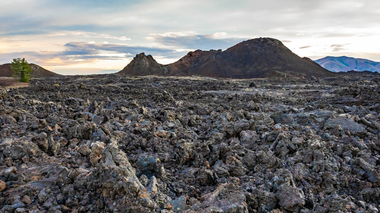
With almost 400,000 acres of cinder cones jutting from the earth, lava flows twisting and contorting across the plain, and cave systems tunneling deep beneath the surface, Craters of the Moon is unlike anything else in the continental U.S. It's so otherworldly that NASA sent its Apollo astronauts there to study its geology in order to prepare for the stark landscape of the moon. The monument occupies a vast stretch of the Snake River Plain in Idaho, and the landscape erupted in eight phases across 13,000 years. Lava flows were forced up through the Great Rift, which runs for 62 miles across the plain. But the volcanoes now lie dormant.
The Shoshone, who have lived in the area for millennia, have a legend about this mysterious place. According to the tale, a giant snake that was so furious after being awoken from its slumber wrapped itself around a mountain until it exploded. The cinder cones and the lava fields, they said, were all that remained of the creature. To get a good view of this fractured expanse, you can hike to the rim of Inferno Cone. You'll see the black rock, jagged and collapsed, stretching unbroken to the Pioneer Mountains on the horizon.
The dark hours attract keen astronomers, as the absence of light pollution transforms the sky here into something quite spectacular. Craters of the Moon National Monument is an International Dark Sky Park. You'll see the Milky Way glowing overhead, dense and vivid in a way most people never get to see it. Yet despite all the extraordinary sights on offer at Idaho's most surreal national monument, the 260,000 visitor numbers in 2025 seem remarkably low.
John Day Fossil Beds National Monument, Oregon
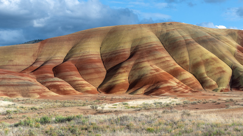
There are three units at John Day Fossil Beds National Monument: Clarno, Sheep Rock, and Painted Hills. But it's the smooth, rounded hills that sweep up from the valley floor at the latter that are the most visited of the three. They are precisely layered in saturated bands of red, orange, mustard yellow, and olive green so vividly that they look less like geology and more like those sand art bottles that were once so popular. Each distinctive stripe represents a different chapter in the history of climate change, preserved in ancient soil over tens of millions of years. One day, someone or something may even look back at our own colored chapter. For now, most people pass through Oregon oblivious to the hills' existence — just 131,100 people visited the monument in 2025.
John Day Fossil Beds National Monument is basically a 45-million-year-old fossil record. Rhinoceroses, oreodonts, mastodons, camels, and ancient horses once roamed this landscape, their remains now preserved in volcanic ash with extraordinary precision. The Clarno unit is where you'll see fossils embedded in rock, while towers of ancient lava have eroded into something resembling the battlements of a ruined castle. Palm trees once grew here, as the climate shifted from subtropical to temperate over millions of years. It's all written in the rock. The Thomas Condon Paleontology Center in the Sheep Rock unit is where you can see the scientists at work, their benches cluttered with skulls, leaf imprints, and insect remains, all pulled from the ground outside.
San Juan Islands National Monument, Washington
The San Juan Islands form a sprawling archipelago of 450 islands and rocks scattered across the Salish Sea in northwestern Washington. Within these islands is a scattering of Bureau of Land Management (BLM)-controlled land spread wide across 84 parcels of small islands, rocks, and reefs. They are undeveloped spots with no roads, no facilities, and very little infrastructure, and together they constitute the San Juan Islands National Monument. It was President Obama who designated it in 2013, protecting the heritage of the Coast Salish peoples, a broad grouping of Indigenous nations connected by shared language and culture, who have called this place home for at least 12,000 years.
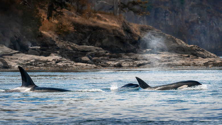
The waters around the San Juan Islands are a hub for wildlife, especially whales. You'll find the endangered Southern Resident orca among them, with Turn Point on Stuart Island being one of the PNW's best spots for watching them from shore. Humpbacks and grays also pass through on their migrations, while you'll see harbor seals and Steller sea lions hauling out on the rocks. You won't be jostling to get photos of them, either, as just 240,449 people visited this underrated place in 2024.
The islands of Lopez, Shaw, Orcas, and San Juan are all reached by ferry from Anacortes and have all the roads, towns, and infrastructure you need. From there, you can find kayaks, private boats, and guided tours that provide access to the monument's wildly pristine views and fun activities. You needn't sit around and wait for the weather, either. The islands receive just 19-29 inches of annual rain, and the sun bathes them in its nourishing glow on 247 days — quite the contrary to what you might expect in the Pacific Northwest.
Newberry National Volcanic Monument, Oregon
Newberry Volcano has a history stretching back more than 600,000 years, and today the Newberry National Volcanic Monument protects 55,500 acres of its most spectacular features. The 75-mile-long volcano stretches for 27 miles at its widest point and sits within the Deschutes National Forest, about a 15-minute drive from Bend. However, with so many more famous attractions in the area, the Newberry National Volcanic Monument is one of Oregon's lesser-known destinations. For more than 10,000 years, it has been a place of profound importance. Long thought of as a gift from the Creator, Indigenous peoples quarried obsidian here for arrowheads, knives, and ceremonial objects here.
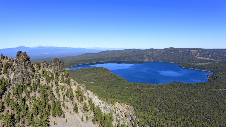
The monument has three areas preserving lava flows, underground caves, crater lakes, and obsidian fields. Lava Lands is where you'll find the incredible Lava River Cave. At one mile long, this vast tunnel of amber and gray volcanic rock is Oregon's longest lava tube — and walking through it is an otherworldly experience. Lava Cast Forest is where you can discover the ghostly remnants of trees entombed by molten rock around 7,000 years ago, while the Newberry Caldera is where you'll behold the most dramatic scene of all. Here, jagged volcanic spires frame the turquoise Paulina Lake ringed by verdant slopes in the belly of this active volcano. You'll see the snow-capped Three Sisters sitting on the horizon across a vast forested plain, with the broader Cascade Range stretching out beyond. It's quite the scene. For an even bigger picture, you can hike or drive to the summit of Paulina Peak for a 360-degree panoramic view of the full Cascade Range.
Hanford Reach National Monument, Washington
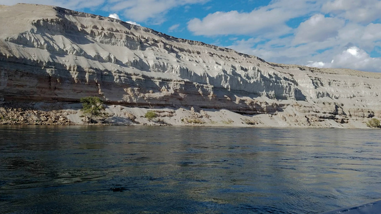
For over 50 years, the land surrounding Hanford Nuclear Reservation was a sealed-off security buffer for nuclear weapons development. From 1943, nothing was planted, nothing was built, and nobody ever visited. It was an enforced isolation that eventually became unintended conservation. While the rest of eastern Washington lost most of its shrub-steppe to agriculture and development, the Hanford buffer zone remained wild. Just after the turn of the century, President Clinton designated the area a national monument, and today, the Hanford Reach National Monument covers 195,000 acres of desert, river, and shrub-steppe. At its heart is the last free-flowing, non-tidal stretch of the Columbia River — undammed, unmanaged, and uninterrupted for 51 miles.
On one side of the river, you'll see the White Bluffs. These layered sedimentary cliffs rise sheer from the water and stretch for miles. They are packed with the fossilized remains of ancient animals like the rhinoceros, mastodon, and giant ground sloth and are home to nesting prairie falcons. The mighty Columbia supports one of the last great naturally spawning runs of fall Chinook salmon in the American West. In fact, the world-class fishing here is one of the monument's main draws. You can also cast for steelhead, white sturgeon, largemouth bass, and walleye, and if you take a boat out onto the river, the only sounds you'll hear are gusty winds and the water lapping at your boat.
That tranquility is mostly down to the fact that hardly anyone comes here. There are almost no facilities, no signs, no trails, and no visitor center. Perhaps not what you'd expect at a national monument, but it's that untouched quality that makes it all the more appealing to those who do make it.