
9 Once-Thriving Historic Roads And Highways That Now Lie Abandoned
Roads are designed to carry traffic. That is, in fact, their entire purpose. Due to this, roads and highways that have been abandoned can be simultaneously unsettling and fascinating. Much like abandoned travel destinations that no longer exist and once-thriving hotels that have fallen to ruin, former roadways' crumbling blacktop and concrete get buried under plant overgrowth, overpasses lead to nowhere, and tunnels turn into dark, dank reminders of past drivers. However, some abandoned roads also often hold a great deal of historical significance.
Here, we'll take a trip to nine once-thriving historic roads and highways that now lie abandoned around the world. Some became defunct because they were extremely dangerous, while others were simply the collateral damage of progress. For modern explorers, visiting the sites where these roads once ferried thousands upon thousands of vehicles can be a thrill.
To put together this guide, we used the official webpages for various government and academic institutions, including the United States Department of Transportation, the National Park Service, Chapman University, and Australian National Parks. We also turned to news sources like the Canadian Broadcasting Corporation (CBC), the British Broadcasting Corporation (BBC), and PBS SoCal. Official tourism websites like Visit Springfield, Illinois, and Visit Arizona also assisted with key details.
Route 66 at Carpenter Park (Illinois, US)
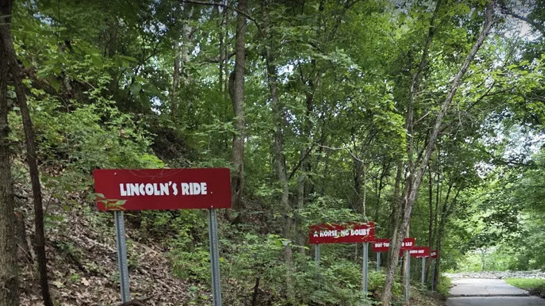
Although Route 66 has not officially been part of the U.S. Highway System since 1985, much of the "Mother Road" is still accessible today, and it remains an iconic, must-do road trip for those who want to get their kicks on Route 66, as the song goes. There is a quarter-mile section of the original Route 66 near Springfield, Illinois, though, that was abandoned nearly a century ago. This small section of road in Carpenter Park was used by travelers between 1926 and 1936, until the highway was rerouted.
The surrounding trees threatened to reclaim the roadway entirely, and it still sits in a thickly forested area. Fortunately, preservationists stepped in to prevent this portion of Route 66 from being forgotten. Instead of letting this piece of All-American culture disappear into the foliage, local groups worked to turn the site into a tourist attraction. In 2025, the Greater Springfield Chamber of Commerce even hosted a ribbon-cutting ceremony to celebrate this slice of American history officially reopening to the public for the first time since the 1930s.
Local news source Capital City Now reported that many major players in the region, including Springfield's director of tourism, mayor, and state senators, were thrilled with the event. Visitors can enjoy walking along this historic section of Route 66, take photos at various photo spots, and immerse themselves in 1930s culture with themed advertisements along the route. In addition to the Carpenter Park alignment, Illinois is home to several other portions of Route 66, many of which travelers can still drive on.
The Canol Road (Northwest Territories, Canada)

Canada's Northwest Territories are a wild place, home to remote reserves where bison roam and the deepest lake in North America. History buffs can also find remnants of the abandoned Canol Road project, a haunting reminder of World War II. Fearful of running out of oil to supply its troops in Alaska, the United States military funded the construction of a pipeline and road — the Canadian Oil (Canol) Road — that would ultimately run to the Yukon. The project was ill-fated, ultimately going more than $100 million over budget.
In addition to the cost, the project is believed to have used more oil than it ever yielded. And, if that wasn't enough, the United States government stopped using the pipeline in 1945 — the year after it was completed. Today, an abandoned 231-mile section of the "Canol Road Folly" is called the Canol Heritage Trail. It is considered one of the longest, toughest, and most adventurous hikes on the continent, and it is not for the faint of heart! If you choose to embark on this two- to three-week-long hike yourself, make sure you properly prepare. Suggested supplies include "a pack raft for the river crossings, food drops arranged ahead, a satellite phone and bear spray."
You can also still drive on portions of the Canol Road, which is a less intense experience, but may still come with its own fair share of surprises. One Facebook user shared a tale of spending over $200 USD on gasoline to fill their tank a single time on the North Canol Road! However, the road rewards those who brave it. The north section's "graveyard" of abandoned military vehicles is a popular destination, as is the Ross River Suspension Bridge, which was constructed during the pipeline project.
The Abandoned Pennsylvania Turnpike (Pennsylvania, US)
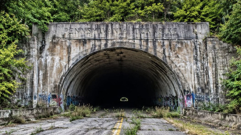
The Pennsylvania Turnpike opened to vehicle traffic in 1940 and quickly earned nicknames like the "Tunnel Highway" and "America's Super Highway" thanks to its seven tunnels and immense popularity. Its success actually backfired, however, because the engineers behind the project had grossly underestimated how many vehicles would use the turnpike. In its first year of operation, 2.4 million automobiles drove on this roadway, nearly double the anticipated traffic.
As a result, traffic jams were common, and authorities made the decision to reroute 13 miles of the original Pennsylvania Turnpike in 1968, and the abandoned section is still there today. It has become a popular stop among urban explorers and history enthusiasts. Graffiti-covered walls, crumbling bridges and concrete, and overgrown vegetation give the entire area a post-apocalyptic feel. The vibe is so intriguing that the Bloodhound Gang shot the music video for their 2005 song "Foxtrot Uniform Charlie Kilo" here. The derelict tunnels have served as filming locations, as well, most notably in the 2009 post-apocalyptic film "The Road."
Although the abandoned Pennsylvania Turnpike is not officially open as a tourist attraction like Carpenter Park's old section of Route 66, many bikers, hikers, and adventurous souls still venture here, assuming personal liability for any injuries or issues they encounter. The Pike 2 Bike trail is a well-reviewed path, with AllTrails reviewers raving about their experience. One person wrote, "Great ride and cool tunnel," while another said, "It was beautiful but in the tunnel is creepy and eerie! It got my heart beating so fast. Definitely good one." It is advisable to bring reflective clothing and flashlights if you plan to visit.
The Ridge Route (California, US)
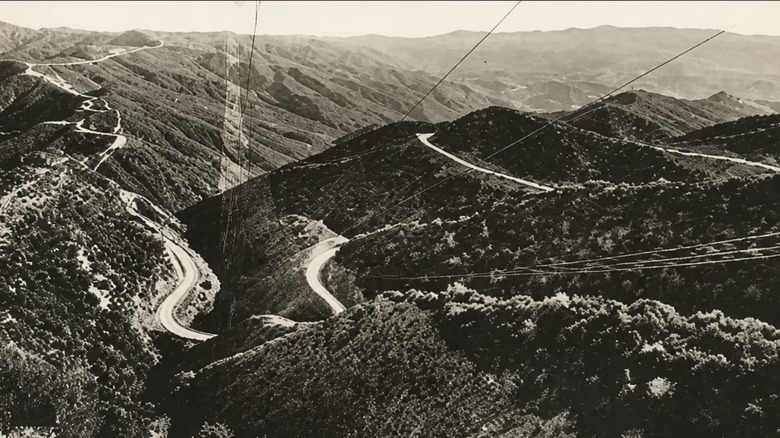
Prior to California's Ridge Route opening in 1915, people who needed to get from Los Angeles to anywhere in Northern California, or vice versa, had to cross the Mojave Desert or take what is now US 101 along the coast, neither of which was particularly direct. The Ridge Route was cut into the mountains, connecting Southern California cities with the Central Valley for the first time. Although it was a much more convenient alternative than the previous options, it still took up to 12 hours to traverse and came with many hazards for drivers.
The Ridge Route required driving on steep grades, navigating numerous hairpin turns, and trying to survive cliffside drop-offs amid mountainous terrain. As one might imagine, it was a harrowing experience. In just seven years, between 1921 and 1928, 31 people perished on this road. Unsurprisingly, it didn't take long for the Ridge Route to become rather notorious, if a bit romanticized, for its spirit of adventure. In 1933, a new roadway, aptly named the Ridge Route Alternate, opened, affording drivers a safer way to cross the Golden State. Today, various sections of abandoned pavement remain, visible to hikers and modern Interstate 5 drivers.
Dead Man's Curve is one of the most well-known locations that still exists. In a Facebook thread about this dangerous turn, one commenter confirmed that it "was a very scary ride back in the 40's." Although the original Ridge Route was decommissioned in 1934, some drivers, like this person's parents, presumably continued to travel on it for the scenery. Travelers can also still see ruins of places like the Tumble Inn that once served motorists. The Ridge Route Preservation Organization tirelessly works to maintain this historic roadway.
East Old 180 & Route 66 (Arizona, US)
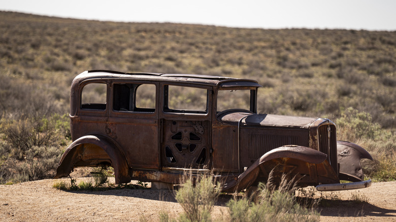
Petrified Forest National Park in Arizona may be best known for its colorful fossilized wood and dramatic rock formations, but it is also a great destination for history buffs who are interested in the evolution of American highway transportation. Visitors here can find remnants of not one, but two, historic roads: East Old 180 and Route 66. Today, drivers can enter this National Park via the modern US 180, but drivers once used the old road to see a large area of petrified wood up close.
Eventually, authorities opted to reroute 180 into its current alignment, primarily in a bid to prevent people from so easily disturbing or taking fossilized wood specimens. The remaining section of East Old 180 is still visible, but has been left to the land, which can be unforgiving in the Arizona desert. It may eventually erode entirely, but portions of the roadbed can still be seen today. The National Park Service notes that the eastern portion of this historic highway is especially weathered at this point.
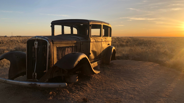
Route 66 aficionados, meanwhile, should look for a rusted 1932 Studebaker that now serves as a marker for the one-time location of the Mother Road's pullout. Other Route 66 sites within park property include what was once the Lion Farm, which was a controversial tourist stop with snacks, souvenirs, and, yes, actual mountain lions in captivity. It's easy to visit the remnants of both of these historic roads during a day trip to Petrified Forest National Park. Simply make sure you follow all park regulations, such as adhering to posted opening hours and obeying all park ranger instructions.
Old Pali Road (Oahu, Hawaii, US)
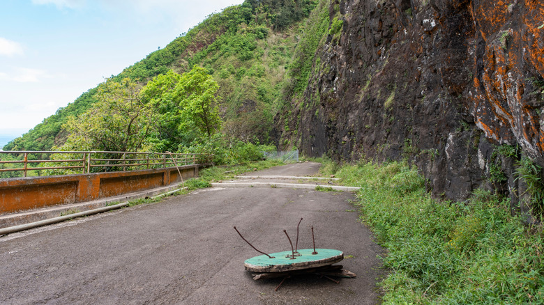
Before there were modern highways, crossing the Ko'Olau Mountains on Oahu was a hazardous undertaking. Native Hawaiian people had been traveling across this range on foot for centuries, long before Westerners arrived. The first roadway here, intended for horse travel, opened in 1845, and was converted to the original Nuʻuanu Pali Road (Old Pali Road) in 1898. In the intervening decades, before the first highway was constructed, numerous safety warnings were issued, especially to those attempting to cross the mountains in top-heavy buggies.
Adding to the spookiness are the more than 800 skulls that were unearthed during the construction of the Old Pali Road. While they were found to belong to warriors who were forced off the cliff in the Battle of Nuʻuanu in 1795, rather than travelers who encountered an accident, their discovery still adds to the lore of this being dangerous terrain. Although the roadway was well-engineered for its time, with wooden guardrails and a gutter system, early 20th-century motorists still had to drive on sharp curves and steep hills. The experience of driving here would have been particularly alarming in rainstorms or high winds. A historic photo shared by PBS on Facebook even shows waterfalls blowing backwards in a windstorm on this route!
Today's Pali Highway and its tunnel system opened in 1957, leaving much of the original roadway abandoned. However, it was not forgotten. Today's visitors can view what remains of the route from the Nuʻuanu Pali Lookout, as well as hike on sections of the Old Pali Road. One Tripadvisor reviewer had a unique experience, writing that they "took a walk down the Old Pali Highway from the lookout, and when I was returning, the wind literally blew me uphill."
The Old Plank Road (California, US)
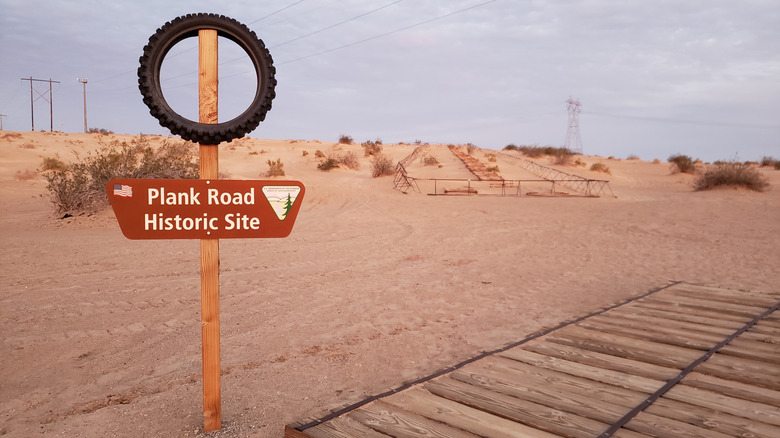
In the early days of automobiles, crossing Southern California's Imperial Sand Dunes was a next-to-impossible task. Tires often got stuck in the soft sand, leaving drivers stranded in No Man's Land between San Diego and Arizona. Without cell phones, motorists had to fend for themselves to get out of their predicaments. As a solution, a plank road was constructed in 1915. Now referred to as the Old Plank Road, this makeshift road consisted of two sets of narrow wooden boards over about seven miles, so drivers had to be careful to not veer off course by even a few inches.
The roadway became quite popular, to the point that it had to be enhanced by 1916, just a year after it opened. At that point, workers redid the Old Plank Road using railroad ties, which gave drivers a more stable surface that was about eight feet wide. Every 1,000 feet, there was even a pull-off point to allow passing. Even with these major upgrades, though, this desert road had to constantly contend with the elements. Wind blew sand onto the planks nearly all the time, so teams of horses were used to accomplish the tedious task of moving the road around as needed.
After about 10 years of service, the Old Plank Road was replaced by a paved byway that is now Interstate 8. History enthusiasts can enjoy a preserved segment of the original abandoned road near Winterhaven, California. For those researching how to visit, the site is officially referred to as California Historical Landmark No. 845. Visitors are welcome to take photos with the historic marker and can even stand on a section of the planks. There are also informational signboards that outline this location's importance.
The Old Great North Road (New South Wales, Australia)
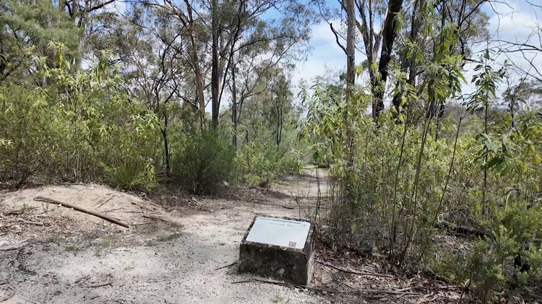
Australia's Old Great North Road is a remarkable surviving relic of the nation's convict heritage. Constructed between 1826 and 1836, more than 700 prisoners provided the intense labor necessary to complete this massive roadway. The original Great North Road was over 150 miles long, and building it also required the convict crews to construct infrastructure like bridges, buttresses, and huge, 30-foot-tall retaining walls. However, despite the mammoth efforts that went into creating the Old Great North Road, very few people ever used it on a regular basis.
One issue was that the Old Great North Road was not built near population centers, so people had to go out of their way to get to it. Additionally, because of its remote location, there were no convenient stopping points for necessities like water and food. Ultimately, ships and steamers became Australians' preferred method for traversing New South Wales. The fact that the Old Great North Road was hardly used, though, means that it's an incredibly well-preserved site from the convict era today.
Vehicles are not permitted to drive on the abandoned route, but hikers, walkers, and cyclists are welcome to explore. About 10 miles of the one-time road can be found in Dharug National Park, where many visitors enjoy taking the Devines Hill Loop, which offers a look at some of the walls left over from the original road. The historical significance of the Old Great North Road in Australia cannot be overstated. Of the thousands of national sites connected to convicts, this road is one of only 11 locations that comprise the official Australian Convict Sites World Heritage list.
The A3 at Hindhead (Surrey, England)
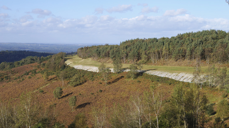
The A3 is still a key highway that connects London with coastal Portsmouth, but its current alignment didn't exist until 2011, when the road's old surface route in Hindhead was removed in favor of the Hindhead Tunnel that runs under the Devil's Punch Bowl formation. The now-abandoned Hindhead portion of the A3 was infamous for its wild traffic jams. Today, this area has been returned to nature, and the infamous Devil's Punch Bowl — which has ties to a 1786 highway murder — has a historic marker.
Diverting the A3 through the tunnel system has had numerous environmental and societal benefits. Local air quality has gotten better, rare insect and bird species have come back to the region, and residents can now enjoy nature in a new and exciting way. Under the care of the National Trust, there are numerous ongoing efforts to restore native flora and fauna in the Hindhead area. Visitors who come to the nature preserve can enjoy a variety of activities, including hiking, playgrounds for children, and guided tours about the site's history.
Another highlight here is the Devil's Punch Bowl Cafe, where guests can enjoy a beverage and a bite to eat amid the gorgeous landscape. Although much of the old A3's pavement was removed as part of the natural restoration project, the roadbed's curvature and winding turns are still visible. Hiking along this route is a unique way to experience what was once one of the most notoriously busy roads in England.