The 'Most Pleasant 44 Miles In America' Is An Idyllic Arizona Scenic Byway Into Grand Canyon National Park
Editor's note: This article was published prior to any wildfire activity that may affect the region. Please check local reports and forecasts before making travel plans.
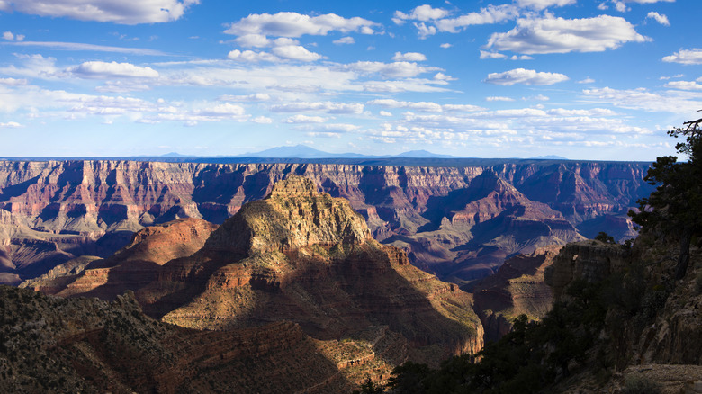
Grand Canyon National Park encompasses 1.2 million acres over 1,904 square miles and welcomed nearly 5 million visitors in 2024. It is arguably one of the leading attractions in Arizona, and tops many travel bucket lists — visitors aren't asking if they should go, but when, and you'll have to decide on the ultimate time of year to plan your trip to the Grand Canyon since there's so much ground to cover for both the North and South Rim excursions. A trek to the North Rim at over 8,000-foot elevation must be aptly timed, as it's more secluded than its southern counterpart. To reach this more secluded side of the 1-mile deep canyon, the Kaibab Plateau-North Rim Parkway is an idyllic scenic drive that leads into Grand Canyon National Park.
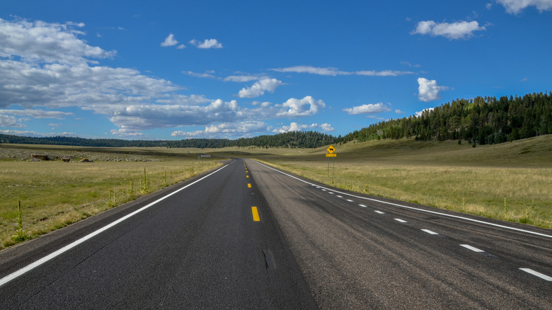
The Kaibab Plateau-North Rim Parkway, known as Grand Canyon Highway, is designated as a National Forest Scenic Byway and an Arizona State Scenic Byway along 44 miles of Arizona State Highway 67 from Jacob Lake to the Grand Canyon's North Rim. It's affectionately earned the nickname of "the most pleasant 44 miles in America" because it travels through diverse landscapes, offering travelers an up-close look at forests, lakes, and even wildlife. While the official byway begins at Jacob Lake, visitors may find themselves starting 30 miles north in Fredonia, the gateway to the Canyon's North Rim that is prime for adventure with access to three national parks (and it's the closest town with full services). This scenic drive requires a sense of adventure and a camera handy, and is best experienced May through October. It's an ideal way to view one of the seven wonders of the World from your car window if you can't or don't want to walk it.
What to see and do along the Kaibab Plateau-North Rim Parkway
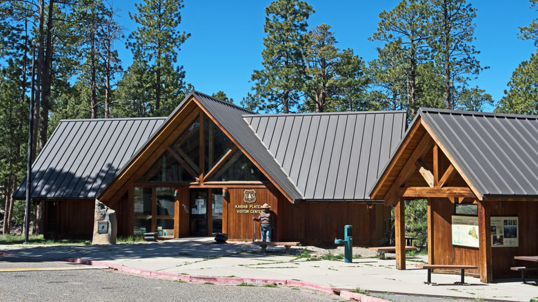
As you begin the byway in Jacob Lake, the lake and small town is your first destination. A stop at the Kaibab Plateau Visitors Center will teach you about the surrounding Kaibab National Forest and offer your first introduction to Grand Canyon National Park. If you're itching to stretch your legs, consider either the easy 2-mile round-trip Jacob Lake Trail or the 1-mile loop Kai-Vav-Wi Nature Trail.
The Jacob Lake Recreation Area is a great picnic spot and is home to the Jacob Lake Campground, where you can sleep under the stars. The Jacob Lake Inn is a camping alternative and offers motel rooms, rustic cabins, a restaurant, and a small store. Eight miles south through the Kaibab National Forest, the smaller Murray's Lake with a trailhead is up next as you drive through a forest rich with ponderosa pines, firs, and several other tree and flower species. Then The Meadow near Crane Lake comes into view, often awash with wildflowers in the spring; sometimes there is even a herd of bison visible here.
A more challenging hike, the Kaibab Plateau Trail, lies about 26 miles south from Jacob Lake, heading 7.5 miles each way as part of the longer Arizona Trail. You can access it from the turn off for the East Rim Viewpoint off of Forest Road 611. From this road, you can veer off through the less prominent Saddle Mountain National Forest and the 8,419 foot high Saddle Mountain, which is the highest mountain in Grand Canyon National Park. Many visitors find themselves grappling with which rim of the Grand Canyon offers the best hike for what you want, and for experts the less crowded North Rim offers 12-day hikes.
Experience the North Rim of the Grand Canyon, and important tips for trekking the Kaibab Plateau-North Rim Parkway
Once you hit the far southern end of this drive, you'll find yourself at Bright Angel Point and the Grand Canyon Lodge. A designated National Historic Landmark, the Lodge is the only lodging and dining options for those spending time along the less crowded North Rim. At the park entrance station, you'll need to pay the $35 entrance fee or show your annual pass, and be sure to make a stop at the Visitor's Center for park information and maps.
If you choose, you can reverse course from the Lodge and entrance station to Cape Royal Road which leads to a fork at Point Imperial Road and the Point Imperial Viewpoint, the highest view of the North Rim. Staying on Cape Royal Road will lead to more scenic viewpoints and the half-mile Cape Royal Trail, and potential for wildlife viewing. As one TripAdvisor user put it, the drive is "spectacular" and easy to fall in love with, and they recommend not to bypass the North Rim.
You'll need to plan your venture along the blissful byway carefully, as Highway 67 is closed during the winter months due to potential heavy snow. Depending on your activities and access to them, some portions may be best for a high clearance or sport utility vehicle. Finally, with limited services in this remote region, be sure to carry enough water and provisions and follow "no trace" principles. You also may choose to access this drive from Flagstaff, where you can stargaze at the world's first international dark sky city, or Kanab, Utah, a scenic laidback western tourist town situated in the middle of Southern Utah's greatest outdoors.