
America's 12 Canyons That Are Best-Kept Secrets From Tourists
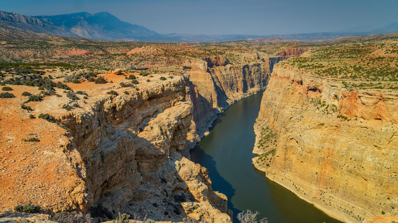
The Grand Canyon is probably one of the first to come to mind when we think of dramatic gorges in the U.S., but it's far from the only one. Utah brims with so many that there's a national park simply called Canyonlands, boasting some of the Southwest's most vibrant views. Even slot canyons like Antelope, located near Page, Arizona, can get crowded with tourists even though they're only accessible on guided tours. Thankfully, not all canyons get millions of visitors each year. Many are extremely remote but with astonishing views to offer if you make the trek. Others are simply more off the beaten track but with a few more amenities for an easy visit.
Below, tour 12 canyons across the West and Southwest that glow with distinctive character, from the deepest canyon on the continent to tucked-away, awe-inspiring slot canyons. You'll find some formal parks that are much quieter than places like the Grand Canyon or Arches National Parks, plus stunning wilderness areas managed by the Bureau of Land Management (BLM). Whether you're driving through, looking for a hike, interested in a pack canoe trip, or simply aiming for one of those "wow" moments with your camera, read on for ideas for your next road trip.
We've focused on a range of canyons and park types for this list to include a spectrum of accessibility. Black Canyon of the Gunnison National Park, for example, is easier for the typical traveler to reach in a standard vehicle than Parunuweap Canyon in Utah, which requires a well-planned overnight hike to experience. The author has also gleaned some of the information shared below from her own travels to a few of these places, plus blogs, canyoneering websites, regional tourism sites, NPS.gov, FS.USDA.gov, and BLM.gov.
Hells Canyon (Oregon and Idaho)
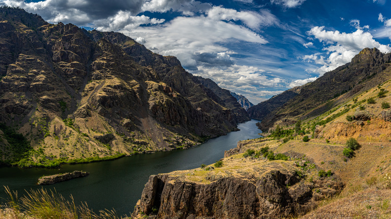
Although Hells Canyon is actually the deepest canyon in America, around 2,000 feet deeper than the Grand Canyon, a lot of it comes down to perception. The latter is still longer, wider, and more voluminous. But if you want a far less touristy alternative to the Southwest icon, consider this Snake River-carved gem in the Northwest, where recreation is a bit more limited to the period between spring and fall but nevertheless a wonderful escape in the mountains at the border of Oregon and Idaho.
Managed by the U.S. Forest Service, Hells Canyon National Recreation Area boasts more than 650,000 acres of gorgeous landscapes characterized by rugged geological formations. Because the Forest Service roads are often composed of dirt, you'll likely want a vehicle with decent clearance. You can pick up physical motor vehicle use maps from any Wallowa-Whitman National Forest ranger station, or you can download individual PDFs online in advance. Floating or boating down the river is another option, although you'll need to make sure to secure a permit via a lottery system. Alternatively, book an exhilarating charter sport fishing trip or tour aboard a jet boat with an outfit like Idaho Fishing & Jet Boat Tours or Snake River Adventures for a high-speed cruise along the river.
Box Canyon (Idaho)
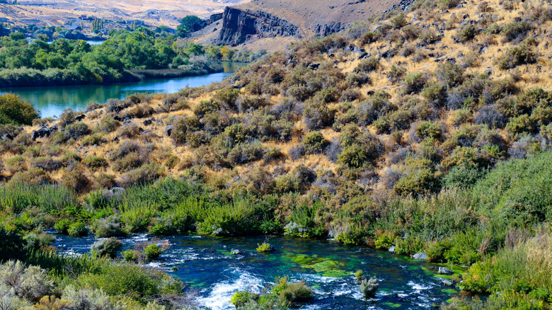
About 300 miles southeast of Hells Canyon in south-central Idaho, Box Canyon State Park and Nature Preserve is part of the multiunit Thousand Springs State Park, which is characterized by a diverse array of bluffs, waterfalls, and natural-fed pools and streams. Box Canyon is a hidden gem, and the area is surrounded by unassuming agricultural land until you reach the scenic lookout at the end of a farm road. There, you'll find a small parking lot, and the state park requires a $7 fee per vehicle.
What really sets Box Canyon apart is its glistening turquoise water, which is inviting for a swim or even just dipping your toes in during a break from a hike. The crystalline waters are the result of a very productive freshwater spring, with a 20-foot waterfall that's a sight to behold no matter the time of year. To reach the pools, you'll need to hike down a trail from the canyon rim to the base, which involves a little bit of scrambling. If you take the hike in a loop, it stretches just about 3 miles.
Bighorn Canyon (Montana and Wyoming)
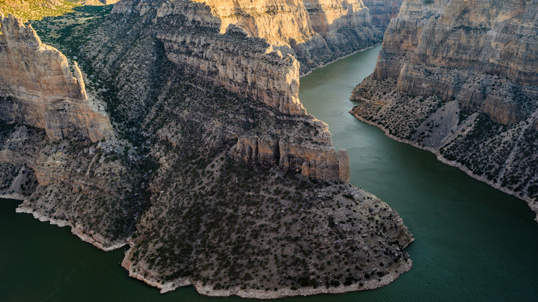
Bighorn Canyon National Recreation Area spans two states across more than 120,000 acres. There are over 17 miles of trails, with ample opportunities for boating and fishing, five campgrounds, and more. Of course, the main feature is the titular gorge that was carved by the Bighorn River over the course of millions of years, augmented by the uplift of the Bighorn Mountains. The river was dammed in the 1960s to create scenic Bighorn Lake, but from the canyon floor to its rims, it ranges from 1,000 to a staggering 2,500 feet deep.
This lesser-known recreation area typically gets fewer than 250,000 people each year, providing enough area to explore so that there's ample space without it feeling totally remote. Head to Devil Canyon Overlook to take in a stunning bend in the river that rivals the famous Horseshoe Bend, one of the most photographed destinations in Arizona. As a matter of fact, one of the campgrounds at Bighorn Canyon is also called Horseshoe Bend, and you can take in similar colorful sedimentary displays on the steep walls. If you plan to hoof it, don't miss the 1.8-mile round-trip Mouth of the Canyon Trail, where you can take in views of the canyon and surrounding mountains, plus peep wild horses grazing around the Pryor Mountain Wild Horse Range.
Santa Elena Canyon (Texas)
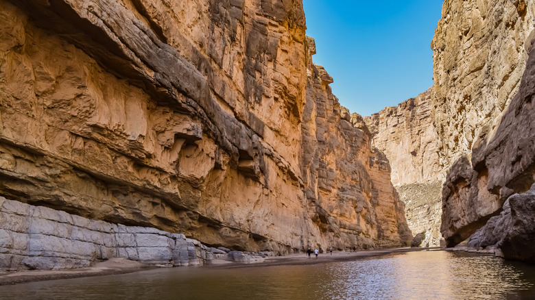
Nestled in the southwestern edge of Big Bend National Park, where it has been shaped over millennia by the Rio Grande, Santa Elena is a gorgeous canyon that welcomes hikers and paddlers to a truly remarkable desert experience. Its walls soar up to 1,500 feet, and you can experience it via a short hike from a trailhead at the Santa Elena Canyon Picnic Area or by water. The latter is a wonderful way to really immerse yourself in the landscape with a day-trip paddle upstream through the canyon and then back down. Big Bend River Tours, for example, leads guided day trips when the water is low, departing from Terlingua.
A more intensive experience comes in the form of an overnight jaunt — some extend it to three days — starting in the west near the community of Lajitas and heading downstream for about 20 miles. About the last third of the route is in the canyon itself, with some light rapids when the water is higher. Just remember that you'll need a backcountry permit from the park for any overnight trips, but day trips are exempt. And while Big Bend had more than 560,000 visitors in 2025, paddling through the canyon can provide valuable tranquility and solitude amid the sweeping stone walls. For an even better chance of having the place mostly to yourself, head there early in the morning, when there's also the added benefit of cooler temperatures.
Diablo Canyon (New Mexico)
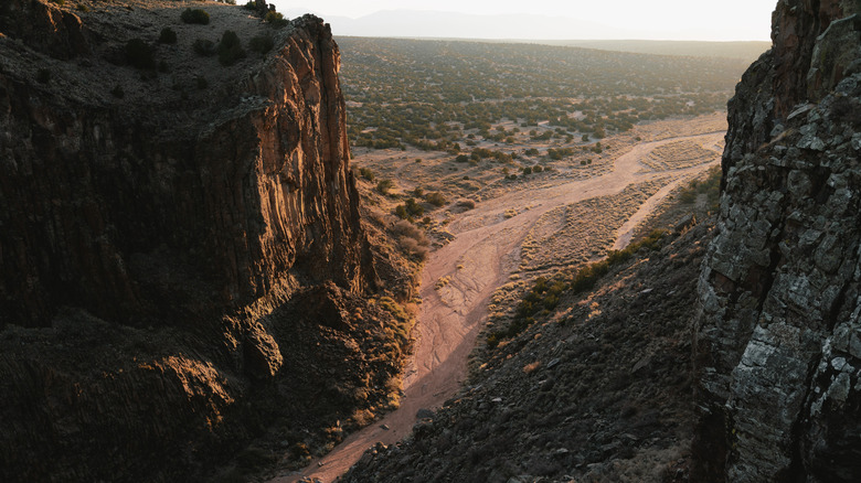
Just a half-hour drive northwest of Santa Fe, New Mexico, Diablo Canyon Recreation Area is characterized by dramatic basalt cliffs that were formed as part of a volcano that erupted about 2.5 million years ago. Although the Rio Grande flows nearby, it's not carved by the river in the same way that the Santa Elena Canyon in Texas has been, for example, so its features and composition have a totally distinctive feel. The area is spectacular for a remote hike or a rock climbing adventure, featuring dramatically dark wall faces.
The trail is actually a wash, which stretches for about 7.5 miles when traversed out and back. It can be muddy if there's been recent rain, and you'll want to be very conscious of the weather in the catchment area to avoid flash floods, which can be powerful and dangerous. When the weather is good, though, bring enough water to stay hydrated in the heat and enjoy this relatively flat wander through an ancient volcanic field. Climbing is also a very attractive opportunity for those who like to earn their elevated view. More than 100 routes span difficulty ratings of 5.8 to 5.13, and in some places, the routes reach an elevation of 300 feet.
Peek-a-Boo Slot Canyon (Utah)
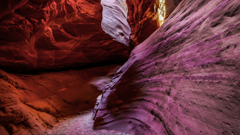
Antelope Canyon may be one of the most famous slot canyons of the hundreds that floods have carved out of the northern Arizona desert, drawing photographers and geology enthusiasts from around the world. But that also means it can be busy despite the visitor requirement of guided tours, many of which are offered in conjunction with nearby Horseshoe Bend. One quieter alternative is Peek-a-Boo, sometimes referred to as Red Canyon, which is across the state line near Kanab, Utah. Unlike many of the other canyons, which are on Navajo Nation land, Peek-a-Boo is on public land managed by BLM, so you don't need a permit or a reservation to access it.
The short hike into Peek-a-Boo slot canyon stretches just about 0.7 miles out and back, but navigability can vary from year to year due to the regular occurrence of flash floods, which change the canyon's shape. Floods are the very reason they exist. Always check the weather throughout the entire region before setting out to avoid dangerous conditions. A thunderstorm several miles away can lead to flooding where you might not expect it. And even when it's dry, be prepared to traverse sand that may be unstable or scramble over a boulder or two. The trade-off is that you get to see strikingly tall, narrow canyon walls with water-sculpted curves that can make you feel like you're on a different planet.
Coal Mine Canyon (Arizona)
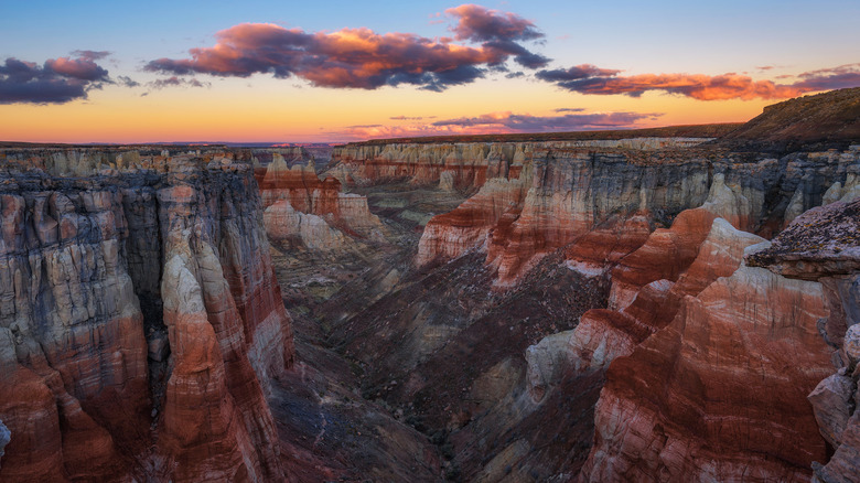
An Arizona gem that straddles the boundary between the Hopi Reservation and Navajo Nation, Coal Mine Canyon (sometimes referred to as Coalmine) is known as the "Baby Grand Canyon," one of the state's best-kept secrets. It's located just off of State Route 264, about 16 miles from Tuba City. From the road, you might hardly guess it's there, and unlike other local hot spots like the Grand Canyon or Vermilion Cliffs National Monument, it's not signposted like a tourist attraction. That means a lot of folks don't even know about it, but making the journey will reward you with glowing sedimentary strata of millions of years of rock formations at the edge of the otherworldly Painted Desert, about 150 miles across which you'll find the lesser-known gem of Petrified Forest National Park.
Because Coal Mine Canyon stretches between Hopi and Navajo lands, you'll need permission if you plan to explore. To visit the rim, apply for a Backcountry Permit from the Navajo Nation's Parks & Recreation Department, or if you're looking for an adventure and a stunning, strenuous hike down into the canyon, coordinate a permit with the Hopi Tribe, which requires a guide. Unlike the way the Navajo Nation makes permits easy to find, there's no straightforward, tourist-focused way to do the same on Hopi land, so you'll have to contact the tribe directly.
Parunuweap Canyon (Utah)
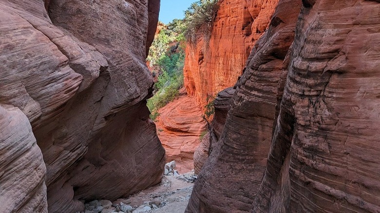
As beautiful and enticing as Zion National Park is — and it's certainly worth a visit — you may be looking to skip the crowds at The Narrows. With its 1,000-foot walls, it perhaps unsurprisingly draws lots of visitors. Tucked away at the southeast edge of Zion, Parunuweap Canyon is a smaller, slightly less dramatic alternative to The Narrows but with far fewer people wading around. It falls into an area of public land managed by BLM called the Parunuweap Canyon Wilderness Study Area (WSA), which follows the East Fork of the Virgin River — the very same that cuts through to make Zion Canyon — and can be hiked for more than 10 miles.
The hike is commonly referred to as The Barracks, and Climb Utah compares it to The Narrows, calling it "just as spectacular as its big brother" but "more remote, seldom visited," with a "poorly marked" and "more difficult" route. For those who love an off-the-beaten-track challenge, though, The Barracks is a bucket list hike. AllTrails features a strenuous route, ideal for backpacking, which starts at Mount Carmel Junction and heads west for 22 miles until it intersects with State Route 9 inside of the national park near the striking Checkerboard Mesa.
Desolation Canyon (Utah)
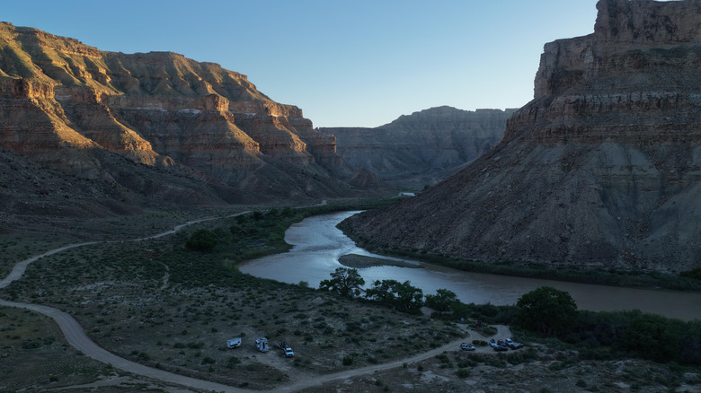
Carved by the Green River in eastern Utah, Desolation Canyon is an expansive, remote destination that's ideal for camping and pack-rafting trips. Managed by BLM, the Desolation Canyon WSA also happens to be the largest single area that the agency manages in the Lower 48, spanning nearly 291,000 acres. It conserves land originally surveyed by 19th-century geologist John Wesley Powell, whose description of the area and its five dozen side canyons as "a region of wildest desolation" lent the place its name (via American Rivers). Today, you can stay in a series of screened cabins and camp at Swasey's Beach Campground. Keep your binoculars handy in case you spot elk, mule deer, bighorn sheep, and other critters.
Desolation Canyon is also joined by Gray Canyon to an 84-mile stretch of river that is a draw for adventurers. Get out on the water to paddle or raft with a permit, which is available via an annual lottery. The area is ideal for multiday trips, with cottonwoods sprinkled along the riverbank for some much-appreciated shade after a long, warm day. Several regional outfitters provide guided trips, such as Adrift, which is based in Moab, or Holiday River Expeditions, which is headquartered in Salt Lake City.
Nine Mile Canyon (Utah)
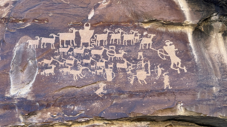
There's "the world's longest art gallery" in subterranean Stockholm, and then there's another that's been around for thousands of years in the desert of eastern Utah: Nine Mile Canyon. As the crow flies, it's not too far north of Desolation Canyon, but driving between them takes about six hours due to the limited route options. You can drive around the canyon itself in a lasso-style loop, starting from Wellington and tracing the Nine Mile Canyon National Backcountry Byway up to the community of Myton, then dropping down again via Sand Wash Road and Wrinkles Road, which eventually hooks back up to the byway and steers back toward Wellington.
This spectacular place actually stretches 46 miles, despite its name. Nine Mile Canyon also brims with geological and human history. Its prehistoric petroglyphs were created by the Indigenous peoples who called this area home for millennia. One of the most famous panels is known as "The Great Hunt," featuring 30 or so bighorn sheep and a group of humans or human-like figures, some of whom carry bows and arrows. See the panel on an easy, 0.2-mile round-trip hike, plus others like the Buffalo Panel and the Owl Panel, which you can also reach with very short walks. Another popular side canyon hike is Daddy Canyon, which you can explore on a 0.9-mile loop.
Black Ridge Canyons (Colorado and Utah)
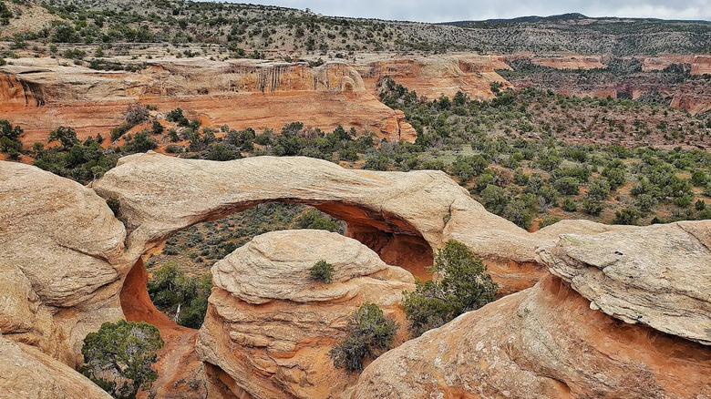
Black Ridge Canyons Wilderness, which is part of the McInnis Canyons National Conservation Area, sits primarily in western Colorado, with just about 7% of it crossing into eastern Utah. It features a series of seven canyons that feature a remarkable number of natural stone arches, spires, and alcoves. In fact, it holds the distinction of having the second-largest concentration of natural stone arches on the continent. The largest concentration is found in the aptly named Arches National Park, where a breathtaking road provides access to all its developed areas. But crowds and difficulty finding parking spaces are unfortunately a big part of the experience during peak times.
Black Ridge Canyons Wilderness is a break from the potential stress of lots of people, where on a hike or a mountain bike ride, you may be fortunate enough to spot a golden eagle, deer, bighorn sheep, and more. For a memorable hike with stunning long-distance vistas and historic structures, head out on the 6.9-mile lollipop loop into Devils Canyon, which is rated moderate difficulty for its length and about 750 feet of elevation gain. And if you prefer to take to the water, the Colorado River beckons for paddlers and rafters, and backcountry camping is a truly immersive experience in nature.
Black Canyon of the Gunnison (Colorado)
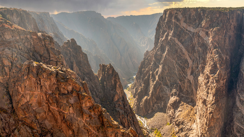
Although there are plenty of stunning, remote, challenging canyons to explore on public lands around the U.S., some are fortunately not too crowded and still very accessible. For an amazing canyon experience that doesn't require a high-clearance 4x4 vehicle or an intense overnight hike, Black Canyon of the Gunnison National Park is a great option. It gets between 300,000 and 400,000 visitors each year, as opposed to, for example, the Grand Canyon's 5 million. This makes for a less busy, more intimate park experience. Like the Grand Canyon, though, its more rugged north rim is quieter compared to its south rim, which is home to the park's main visitor center.
Enjoy camping at the Black Canyon of the Gunnison on either the north or south rim, and hike along a number of trails, most of which are rated moderately difficult. Of course, there's a lot more to the canyon than the rim, and if you're experienced in the backcountry and are up for an adventure, head down into the inner canyon via one of three strenuous hiking routes from the south rim: the Warner, Tomichi, and Gunnison routes. Alternatively, start at the East Portal, where the park's boundary abuts Curecanti National Recreation Area, to kayak on the Gunnison River. Experienced climbers may also want to take on some of the 145 climbing routes rated between 5.8 and 5.13. Fewer than 1% of visitors head into the inner canyon, but if you're up for the challenge, it's an ideal way to find solitude amid a one-of-a-kind landscape.