Michigan's Most Dazzling Trails For Waterfalls, Scenic Views, And Outdoor Fun, According To Travelers
This state in the Midwest has some pretty interesting things going for it. Take its name, derived from the Ojibwa word "mich-gama," which translates to "large lake." Michigan is the only state in the country that is split into two sizable chunks of land — in this case, the Lower Peninsula and Upper Peninsula. And even though the state is full of picture-perfect small towns and a former mining city that now has ski slopes, it also has lots of enviable wilderness. Among all that nature, visitors will find sunsets that are better than the Caribbean and plenty of hiking opportunities.
Michigan is, in fact, blessed with trails. It has the Iron Belle Trail network, hiking and biking routes that wind across the entire state for hundreds of miles. Michigan is also home to the largest section of the North Country National Scenic Trail, which stretches across eight states, including almost 1,200 miles in the Wolverine State. To find the most amazing trails, we scoured information from sources such as Michigan's official tourism site and compiled findings that cover all corners of the state.
Big Carp River Trail, Porcupine Mountains Wilderness State Park
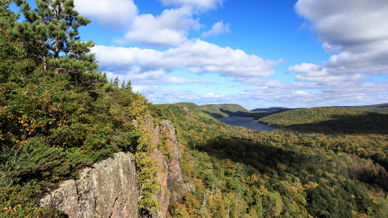
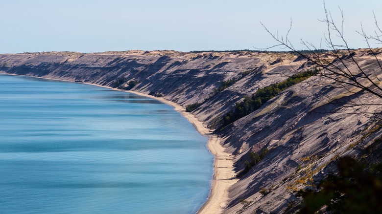
For simple, undiluted praise of this trail on the north coast of the Upper Peninsula, look no further than this comment on Google. "Such a gorgeous place!" For many visitors, this is a hike that most conveniently travels from east to west. The route, which is almost 10 miles in length, begins at an altitude on rugged bluffs that look over mountains. That starting point has a dreamy name, the Lake of the Clouds overlook, and the walk itself traces the lines of the Big Carp River.
The trek itself meanders from that popular viewpoint to off-the-beaten-track parts of the park and finishes at the mouth of the river, where it meets Lake Superior. Along the route, adventurers will come across roaring waterfalls, large tracts of pine trees, and gorges with sheer drop-offs. They will also have the chance to encounter plenty of wildlife, including trout, bald eagles, and black bears.
Chapel-Basin Loop, Pictured Rocks National Lakeshore
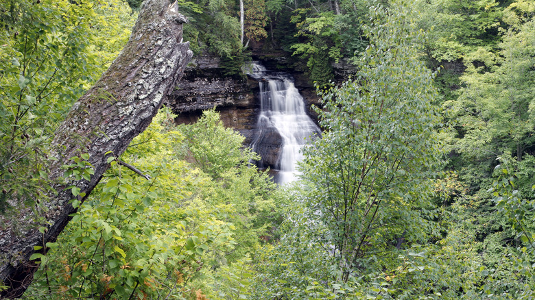
The 10-mile loop is the hike of a lifetime, and takes in beaches, waterfalls, and cliffs. While this trail can be broken down into separate component sections, the full loop is, for some, the most satisfying option. "Did the 10-mile loop, it's an amazing hike!" mentions a Google contributor. "Takes about 5 hours just because you will want to stop every 100 feet to be amazed by the magnificent views!" The route can be done in either direction and passes a number of well-known sites.
Mosquito Falls is where the Mosquito River drops over a series of rocky ledges, resulting in a pretty array of small waterfalls, none higher than 10 feet. Past this, on a trail that is often uneven and can be quite muddy, Mosquito Beach is cupped by soaring cliffs and terraced layers of sandstone. Chapel Falls is equally spectacular. The 60-foot waterfall is reached after a trek through thickets of maple trees. Continue and you will see Chapel Rock, and also Chapel Beach. Walkers should tread with caution, as some of the cliffs are extremely steep and have sheer drops. Pets are not permitted on this hike.
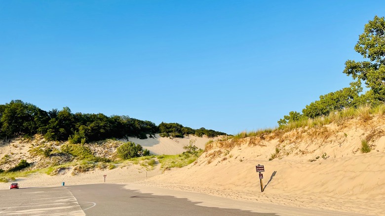
Day-Use Trail, Port Crescent State Park
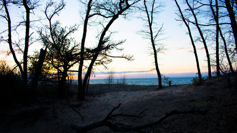
"Love this place," beams a Google commenter. "There are miles of nature trails for you AND ur dog. Always critters to see." This park sits near the tip of the thumb of the Lower Peninsula, so grand, never-ending views of Lake Huron are expected throughout the walk. The hike itself is a little over 2 miles in length. It sends adventurers through expanses of pine and oak and also atop scrubby dunes. Some sections are secluded trails that dive into the woods, others are wooden boardwalks that open to the elements and look out over the water.
Keep your eyes peeled and you might spot geese, deer, and, if you are really lucky, eagles. The hike is designed as a loop, so visitors don't have to worry about trekking back to their car at the end of the walk. Travelers should park at the Steel Bridge Trailhead and expect to clamber up dunes for part of the trek. Some of the higher parts of the hike provide fine views of the Pinnebog River as it empties into Lake Huron. While this is a great hike in the warmer months, also consider embarking on the trip in the winter—the woods and dunes help to lessen the impact of the winds that come off the water during the coldest season.
Empire Bluff Trail, Sleeping Bear Dunes National Lakeshore
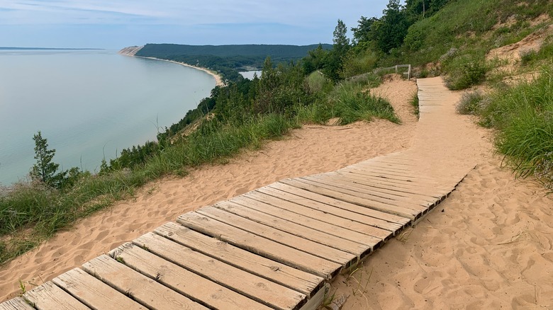
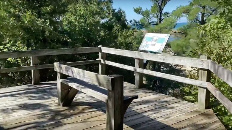
"This walk is a must any time, but especially at sunset," suggests a Tripadvisor contributor. "The views are unrivaled in all of Sleeping Bear Dunes." Forests of maple and beech burst with wildflowers at select times of the year, making this a fabulous springtime excursion. The trail also features areas of dunes topped with plants and open fields. This is not a hard trek, less than 2 miles there and back, and it comes with an impressive payoff.
The hike usually takes about an hour in total and involves some moderate climbs. After winding its way through the forest, the trail places visitors on an elevated bluff above Lake Michigan. Sets of dunes come into focus, as do the clear blue waters of the lake. Travelers can admire the scenery, including views up and down the lakefront, from an observation deck and a boardwalk. Visitors who plan to catch the sunset should bring a flashlight for the walk back, as there is no lighting along the trail.
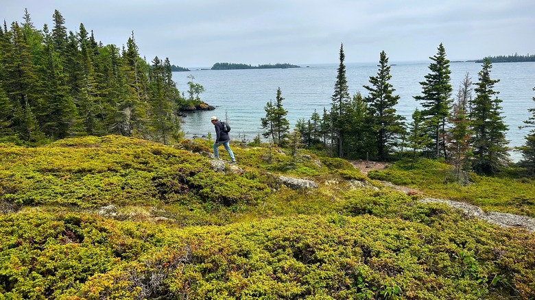
Greenstone Ridge Trail, Isle Royale National Park
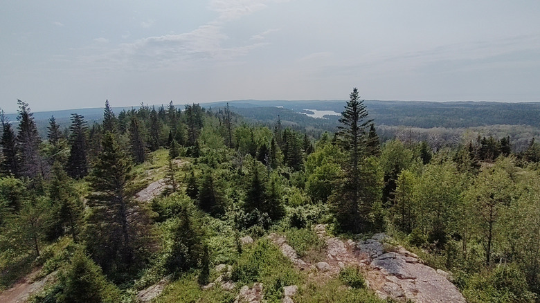
This is not a hike suited for novices, but rather the type of national park trail only for experienced hikers. Greenstone Ridge Trail is a multi-day endeavor that takes in a number of different environments. Travelers are expected to tackle this route as part of a backpacking camping trip, and the entire walk can take up to eight days. But, along the 40-plus miles of walking, they will be rewarded with some incredible sights, as the blog Dirty Shoes & Epic Views details.
"Shoreline walks along Lake Superior, ridge top views over the island, quiet and serene forest walks, hikes through swamp and marsh habitat for good wildlife viewing opportunities, and campsites at peaceful inland lakes where you can fall asleep to the sounds of loons calling out as the sun sets. Sound too good to be true? It's not!" Highlights of this trail include views over the ridge to the lake in the distance. Among the best vistas are those from Ojibway Tower. Other sections roll through hardwood forest and summit Mount Desor, the highest point on the island.
Huginnin Cove Loop, Isle Royale National Park
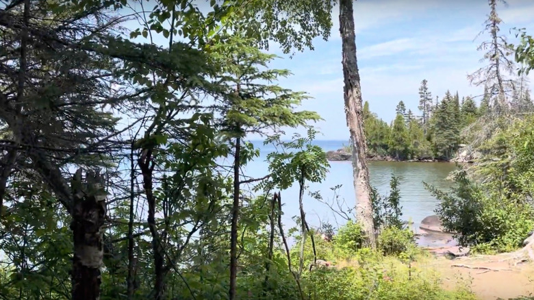
"When we first started on the Huginnin Cove trail, we saw a few other day hikers along the path," relays the blog Erin Exploring. "After just half a mile of hiking, we were the only humans in sight. It was a beautiful summer day, the sun was beaming through the trees, the forest was an explosion of yellow-greens, and all we could hear was the chirping of birds and the shuffle of our own footsteps." The hike can be done in two ways: a long trek that is completed in one day, or split over two days, with a backpacking camping night in between. Either way, hikers will see distant views of Canada from parts of this hike.
Both arms of the loop push out from the Huginnin Cove Campground, but they differ in the terrain they cover. West Huginnin is about 3 miles in length and begins close to Washington Harbor before moving onward toward the coast. This trail runs along Minong Ridge and its trees. The East Huginnin trail is a little longer and begins on the Minong Ridge Trail before skirting an old mine site. The trail also shadows the northern shore of the island and promises fine vistas of Lake Superior and Canada.
Manistee River Trail/North Country Trail, Manistee National Forest
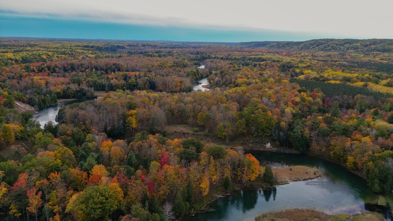
Travelers can access this rural route by taking the short drive from Traverse City, home to one of America's best summer food festivals. The 20-mile combination trail takes in a variety of terrain. The two trails flank the Manistee River, curving and curling through hills and forests, and are usually completed over a series of days. Of the two, the North Country Trail is more of a test for the calves, with hilly sections shaded by trees. At Red Hill Lookout, the vistas take in the undulating Udell Hills.
The Manistee River Trail winds closer to the river. Hikers will notice canoes, kayaks, fishing boats, and even frolickers on inner tubes gliding down the river. The views are also fabulous, with parts of the Manistee River Trail 200 feet above the water. "The Manistee River Trail has such a wide variety of landscapes to discover. Visit during the autumn season for a beautiful display of greens and reds throughout your hike," writes a traveler on Google. "Connect to the other side of the river with the NCT and loop back around to the start."
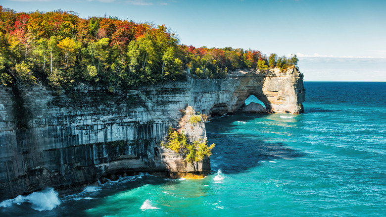
North Country Scenic National Trail, Pictured Rocks National Lakeshore
This stunning Midwest lakeshore hike, formerly known as the Lakeshore Trail, rumbles for about 42 miles as a series of smaller hikes stitched together. Prepare to be dazzled by the scenery. The site Backpacker suggested that this is the 40 most beautiful miles in the whole of the Midwest, with views that are constantly changing. "I assumed the entire hike would hug the shoreline within sight of Lake Superior. In fact, we would pass marshes, hardwoods, dirt paths along beaches, dunes, and old-growth forests. It was not until 6 miles in that we even saw the largest great lake," notes the blog MLG Hikes.
"To the east, 300-foot-tall dunes rising like a wall above the blue water, to the west the Au Sable lighthouse and miles of trees just beginning their autumn transformation, and to the north, the deep blue of Lake Superior stretched as far as the eye could see." In essence, the hike is a passage between the towns of Munising and Grand Marais. Along its breadth, it takes in shipwrecks, sandstone cliffs, lighthouses, mammoth dunes, and a variety of beaches. Travelers should expect to complete the hike in a few days, with campgrounds spaced along the route.
Penosha Trail, Brighton Recreation Area
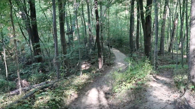
Travelers can tackle this trail as an easy day-trip from Detroit, as it sits northwest of the Motor City. The hike is actually a loop trail, and is 5 miles in total. The terrain varies from flat paths that dissect vast forests to more challenging terrain that rises and falls, providing visitors with a workout. Oak trees and rocks pepper the trail, and there are also kettle ponds along the way.
One of the more notable aspects of the hike is the proliferation of what is known as glacial erratics, or rocks that vary from those typically found in the area. These arrived through the slow, relentless work of glaciers many eons ago. The Penosha Trail is an excellent hike for anyone looking for some nature close to Detroit or Ann Arbor, as this Google contributor notes. "Birds and other wildlife seen along the way with few people. A great way to spend a few hours."
Potawatomi Trail, Negwegon State Park
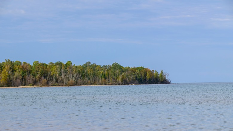
A review on All Trails points to the appeal of this trail. "Very natural and only passed one other hiker the whole time. Lots of wild life including two HUGE deer! Lovely trail." Negwegon State Park unfurls across the east coast of the Lower Peninsula, and, as parks go, it is lightly developed. Access to the facilities, of which there aren't a whole lot, is partly via dirt roads. But such a basic footprint is a boon for travelers in search of some real wilderness.
There are three trails in this park—the Algonquin and Chippewa are the other two—but this trail offers the longest stretch close to Lake Huron. All of the trails are between 3 to 4 miles in length, and form loops. However, the Potawatomi Trail, which comes in at 3.6 miles, has water as a relative constant. Not only will travelers enjoy the lake views, they will also see forests of pine and cedar, and expansive sections of beach along the lakefront.
Pyramid Point Trail, Sleeping Bear Dunes National Lakeshore
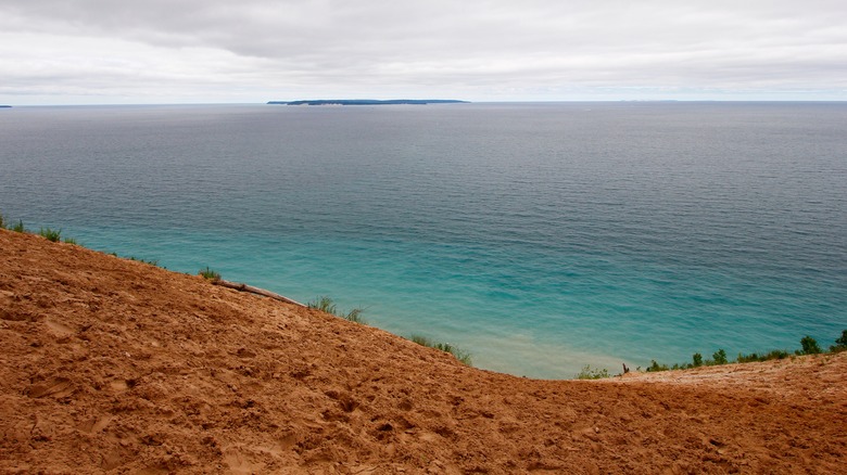
There are a few different options for seeing the most spectacular views from this trail. Some visitors, like this contributor on Tripadvisor, take the path to and from the lookout, a little over 1 mile in distance. "The hike took us about 45 minutes overall, including plenty of time at the end of the trail to take photos and admire the views over the lake and North Manitou Island. Much of the trail is in the shade through the woods, and then at the end you come out onto the bluffs overlooking the lake."
For more exertion, the full trail spans about 2.5 miles and crosses a number of different arenas. Hikers will pass the pastoral bliss of fields and meadows from old farms. They will also weave through beech-maple thickets, some trees more than a century in age. Finally, walkers will find themselves on elevated bluffs, high above Lake Michigan, looking over the lake's awe-inspiring blues and greens. One part of the full-loop trail runs along Basch Road, which can puncture the sense of all-consuming nature. That is why some visitors opt to simply head to the lookout and return.
Skyline Trail, Ludington State Park
This state park sits between Hamlin Lake and Lake Michigan, and is where to find one of the most beautiful beaches in the Great Lakes region. It features many trails, which range in scope and reach. Some can be completed in as little as 30 minutes, while others will keep visitors walking for a relaxing three hours. The Skyline Trail is one of the easiest and most rewarding in terms of views, thanks to its elevated route (hence the name). This hike is one-half mile in length, and takes about 30 minutes to thrash out. It follows the crest of a towering dune, and large parts of it are fitted with a wooden boardwalk.
Throughout the trail, views survey endless expanses of sand dunes and the flats of Lake Michigan. Kids, both big and small, can take a slight detour off the boardwalk and climb up and down the dunes. "Love, love, love the Skyline Trail," explains a Google contributor. "I have been coming here since the early '90s. The trail offers scenic views with a peaceful walk through the canopy." For something more challenging, try the Ridge and Island trails together as a loop hike. Rumbling along 4 miles of the park, and taking about three hours to finish, this hike showcases tree-topped dunes and the open flats of Hamlin Lake
Warren Dunes-Nature Trail, Warren Dunes State Park
In the south of the state, close to the border with Indiana, this park spreads across 1,500 acres of Lake Michigan shoreline. The dunes are the main attraction, forming giant shapes, some higher than 250 feet above the lake's clear shallows. Views from atop the dunes are spellbinding, and visitors can also enjoy 3 miles of waterfront. Other ecosystems include dunes covered in trees, and also wetlands that exist between the dune formations. Birders will enjoy the chance to see many species that stop at the park during migration seasons.
There are a number of hiking trails throughout the park, with 6 miles of routes in all. The Warren Dunes-Nature Trail is one of the easiest excursions. A 1-mile route, it rumbles along a ridge and comes with fine vistas. During the walk, travelers will see the still waters of the lake, the shore of Lake Michigan, and bands of forest. "Trail was very pretty. Few bugs," explains a hiker on All Trails. "Pretty handy through the middle section of the trail. Possible to swim in Lake Michigan if you bring a swim suit!"
Methodology
To find the most amazing trails, we scoured information from Michigan's official tourism site and blogs like Hello Stranger. We were careful to select hikes that were located all over the state and that also would appeal to different categories of hikers, from newbie to expert. For each of our picks, we added first-hand reviews from travelers so that you could get a sense of what to expect from someone who has visited and hiked each choice.