Virginia's 5 Once-Thriving Towns That Now Lay Abandoned
Ghost towns are often associated with the American West, where abandoned towns once served travelers on Route 66 and sprang up during the gold rush, like Oregon's picturesque former mining hub of Cornucopia or the reportedly haunted outpost of Vulture City in Arizona. What many don't realize is that there is at least one ghost town in every U.S. state, including the densely populated states along the east coast. Based on Geotab's research into more than 3,800 ghost towns across America, Virginia has 19, more than the neighboring states of North Carolina (16), Maryland (15), Kentucky (13), and Tennessee (12), and just behind its northern neighbor of West Virginia (21).
Some of Virginia's abandoned towns have been reclaimed by nature, like the one-time mining town of Lignite, now reduced to a few chimneys and foundations along what remains of its main street. Others are inaccessible to visitors, including the remains of Bigler's Mill and Magruder, two small towns seized and emptied by the U.S. Navy in 1942 to make way for Camp Peary. Structures from the towns are still standing but are enclosed within the CIA training facility known by the ominously vague name "The Farm."
The five ghost towns below occupy a sweet spot for visitors: They offer visible evidence of the towns' remains, and each site is legally accessible to the public. Two of them — Union Level and Pamplin — still technically have small populations, but their commercial areas are abandoned, surviving only as relics of the communities that once thrived there.
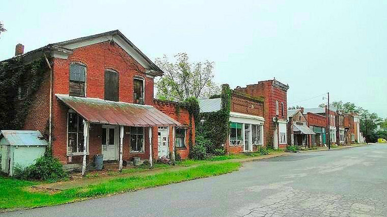
Union Level
While Union Level wasn't officially founded until 1836, its roots date back to before the American Revolution. Fertile farmland drew European settlers in the early 18th century, and the area developed into a supply hub for nearby farming families. A carriage line passed through in the early 1800s, establishing Union Level as a transportation hub – an identity it maintained when the Southern Railway was laid through town in the early 1900s. A railroad depot opened, followed by a bank in 1915. By 1920, it was a bustling town with more than 20 businesses. Then the Great Depression hit. The bank closed first, and most local businesses followed. Union Level hung on in a diminished form until the mid-1980s, when rail service ended. The closure of the post office in 1990 was the final nail in the town's coffin.
There are still 95 people living in Union Level, according to U.S. Census data, but the former downtown area has been completely abandoned. While some of its commercial structures have been demolished, a row of abandoned buildings remains along Union Level Road, alongside an old gas station, Buckhorn Elementary School, and several vacant homes. Zion Church, about a mile south of the old downtown, is still an active house of worship and maintains a cemetery where many former residents are buried.
There has been talk of extending the Tobacco Heritage Trail into Union Level, but for now, the best way to reach it is by car. It's about 90 miles south of Richmond. If you're heading south on I-85, you can stop in the small town of South Hill and get on U.S. Route 1, which will take you the rest of the way.
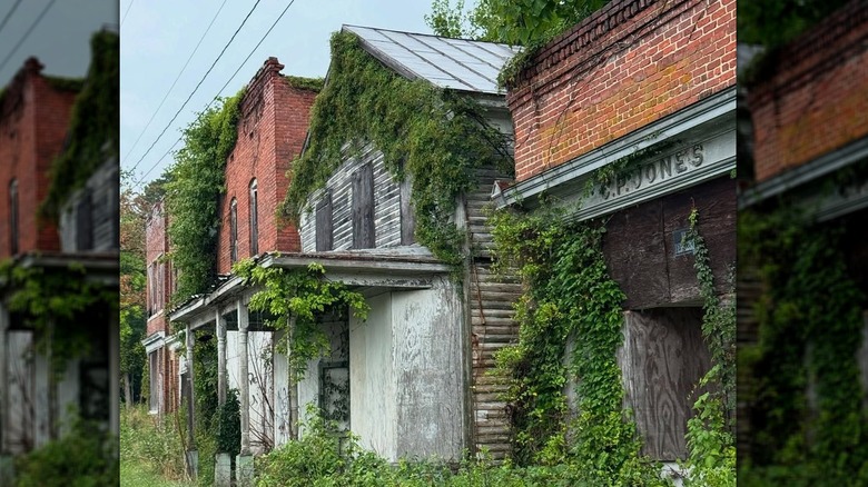
Pamplin
Pamplin is in Central Virginia, about 10 miles southeast of the downtown shops and scenic trails of Appomattox. It marks the western end of the 32-mile High Bridge Trail and lies about a 30-minute drive from High Bridge Trail State Park, the unique park home to Virginia's longest recreation bridge. The trail follows an old railbed – fitting for Pamplin, a town that grew as a railroad hub in the 19th century.
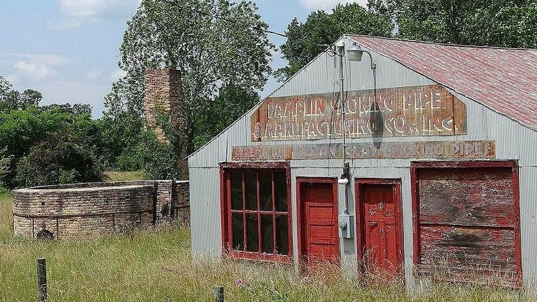
People settled in the Pamplin area starting in the early 18th century, but it didn't see significant growth until the railroad tracks were laid in the 1850s. Following a major fire in 1909, a local ordinance required new construction to use brick, a factor that helps explain why so many buildings still stand today. In its heyday, Pamplin was an industrial town known for its clay pipe manufacturing, producing millions of clay smoking pipes between the 1860s and the closure of its last factory in 1952. Two main factors led to its demise: the shift from railroad to car travel and the rising popularity of cigarettes, which reduced demand for clay pipes. With its main industry gone, the town slowly dwindled.
Like Union Level, Pamplin still has a small population of 118 people, but the downtown is abandoned. Named one of Virginia's most endangered historic sites in 2014, the town has seen some preservation work in its downtown area, including the conversion of the former railroad depot into a community building. However, most of the buildings along the former Main Street remain unchanged since they were abandoned in the mid-20th century. You can also see remains of one of the old pipe factories, which has been classified as an archaeological preserve since 2010.
Matildaville
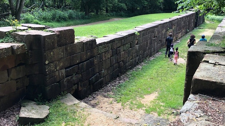
The abandoned town of Matildaville is a hauntingly beautiful site nestled inside Great Falls Park. Where other towns on this list grew over time, Matildaville was intentionally planned and built. It was part of George Washington's plan for a canal system linking the Potomac River to the Ohio River. In 1793, the land was leased by Henry Lee III, father of Robert E. Lee. By 1800, Matildaville was bustling with workers and tourists eager to see what was then considered a great feat of American engineering. Along with the canal, the town had a grist mill, sawmill, and forge, along with stores and housing for workers and the headquarters of the Patowmack Company, which constructed and managed the canal.
Unfortunately, the canals were neither profitable nor particularly functional. Fluctuating water levels made them impassable for much of the year, and the Patowmack Company never recovered the $650,000 it spent on construction. The company dissolved in 1828, and the canals were abandoned two years later. In 1838, the land was auctioned to the Great Falls Manufacturing Company for a water-powered textile factory, giving the town a brief revival under the new name of South Lowell. Arguments over water rights doomed that effort, too. The last holdout from Matildaville, Dickey's Tavern, was destroyed in a fire in 1950.
No standing buildings remain, but the canal bed and locks are still visible. You can also see ruins of buildings like the boarding house, springhouse, and the chimney of Dickey's Tavern. Trailside signs explain what each building was and the history of the canals. The former Canal Street is now part of the Patowmack Canal Trail, which passes between the Matildaville ruins and the canal bed. The ruins can also be seen from the shorter Matildaville Trail.
Ca Ira
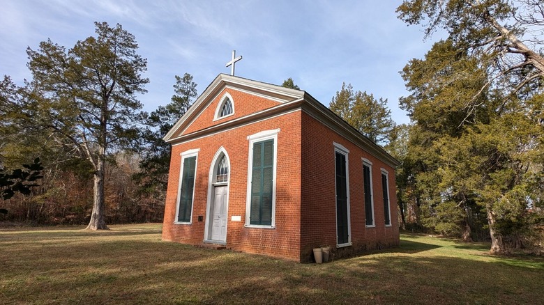
Founded in 1796, Ca Ira remained a small agricultural community until the completion of the Willis River Canal in 1825, which opened it to the tobacco trade. The town expanded into a bustling village of about 40 homes, with a Masonic Hall, a mill, stores, taverns, and tobacco warehouses. Grace Episcopal Church opened in 1843 and served as both a community hub and a place of worship. By the 1850s, Ca Ira had its own bank and seemed poised for continued growth. The Civil War and the subsequent end of slavery disrupted the tobacco economy that the town relied on. Ca Ira never recovered and was mostly abandoned by the late 19th century.
Ca Ira may have been erased entirely save for the efforts of the Ca Ira Restoration Society, which prevented the sale of Grace Church in 1928 and has maintained the property since. The adjacent cemetery is also still there — and still used by some local families — as is one home, the miller's house. Otherwise, the only remaining trace of Ca Ira is Ca Ira Road, a stretch of State Route 632 that passes through where the town used to be.
The remains of Ca Ira are in Cumberland County, a few miles south of Cumberland State Forest. It's an hour's drive west of Richmond or south of the lively college town of Charlottesville. Grace Church holds one service a year to maintain its status as a shrine with the Episcopal Diocese of Virginia, which typically happens at 11 a.m. on the first Sunday of October. This is the best time to visit if you want to see inside the church, but you can explore the cemetery and exterior any time of year.
Wash Woods
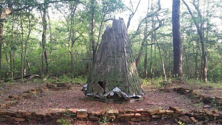
Deep within the secluded coastal paradise of False Cape State Park, Wash Woods is a ghost town that started by accident — or, more accurately, by several accidents. The first settlers ended up there after their ships wrecked nearby. This was a common enough issue during the 17th and 18th centuries that this stretch of coast was nicknamed the "Graveyard of the Atlantic." The dangerous waters prompted Life-Saving Service stations to pop up along the surrounding coast, and many servicemen and their families lived in Wash Woods.
Wash Woods exemplified making the best of a bad situation. When a ship carrying cypress lumber wrecked offshore in 1895, the residents didn't fret; they just used the wood to build the Wash Woods Methodist Church. The town was home to about 300 people until 1915, when the Life-Saving Service merged with the Revenue Cutter Service to form the modern U.S. Coast Guard. Wash Woods lost much of its population following station closures. Intense hurricanes in the 1920s and 1930s drove the rest away, and by the late 1930s, the town was abandoned.
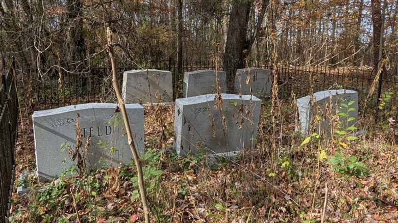
False Cape State Park now maintains Wash Woods, and rangers regularly lead tours of the settlement. You can also explore it independently, though getting there can be challenging. The trails through Back Bay National Wildlife Refuge are closed from November through March, and you can't drive into False Cape any time of year — it's only accessible by boat, bike, or on foot. The most prominent remnant of Wash Woods is the graveyard, whose headstones are well-maintained and mostly legible. The steeple from Wash Woods Methodist Church is also still there, enclosed in a wood-and-glass structure to protect it from further deterioration, and you can see a few brick foundations and rusting boats as you explore the site.
Methodology
The first step to developing this list was to compile a list of Virginia's abandoned towns using Geotab's research on Ghost Towns of America, Trails to the Past's list of Virginia Ghost Towns, and Ever After in the Woods' list of 8 Deserted Ghost Towns in Virginia.
Once we had this list of potential sites to include, we eliminated any that are currently not legally accessible, as well as those where no visible and identifiable trace of the town remains. We also excluded towns that are still viable communities with existing infrastructure and businesses, like Pocahontas, which is greatly reduced from its peak population but was never fully abandoned. As the last step, we selected the five towns from the remaining list that offer the most to visitors in terms of standing structures, ruins, and historical markers.