The 10 Most Rewarding Day Hikes In Utah's Mighty 5 National Parks, Ranked
Southern Utah is quite unlike anywhere on Earth. Vast desert landscapes carved by millions of years of wind and water extend in every direction, forming a maze of towering sandstone cliffs with narrow slot canyons and formations that often defy basic rules of physics. The colors of burnt orange, deep crimson red, pale pink, and creamy white shift constantly in the light, and every hour in this surreal landscape offers a different experience.
Sitting at its heart are the Mighty Five — Utah's otherworldly national parks. They are places where nature becomes a masterpiece, including Arches with its extraordinary concentration of more than 2,000 natural stone arches; Bryce Canyon, an alpine forest that seems to have as many red rock hoodoos as it does trees; Canyonlands, a sprawling wilderness split into three dramatically different regions; Capitol Reef's sweeping landscape of desert vistas and unlimited expanses of deep blue sky; and Zion, a park of iconic trails and towering walls that is one of the most visited in the U.S.
Together, these five parks offer a range of hiking trails, from the short and easy to serious multi-day backcountry routes. Day hikes offer enough time to reach the most spectacular viewpoints, and they demand nothing more than a good pair of boots, plenty of water, snacks, sunscreen, a wide-brimmed hat, and a good phone camera. But don't underestimate them. Some may be fairly straightforward, but others can be dangerous and shouldn't be attempted by anyone not confident in their ability. That said, there are day hikes for everyone in Utah's Mighty Five, and here is our ranked list of the best.
10. Cassidy Arch (Capitol Reef)
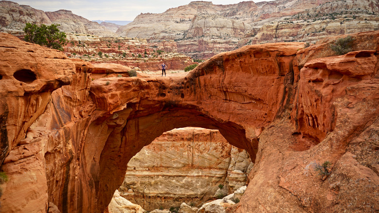
Capitol Reef National Park is one of Utah's most impressive destinations, but its only trail to make this list is the Cassidy Arch Trail. Named after the outlaw Butch Cassidy, who is said to have used the area as a hideout, it's a natural overpass of red rock spanning a large chasm high above the Grand Wash. And unlike most arches in Utah, you can walk straight out onto this one. The trail begins down below, walking along the wash before climbing up natural rock steps, where it levels out along a cliff edge. From there, the path moves onto open slickrock, where you'll find cairns marking the route to the arch. Stick to the cairns because the path can get confusing here, including a false trail that turns right.
You'll have walked 1.7 miles and climbed a strenuous 670 feet by the time you get to the arch. Two to three hours will have passed, but it won't have been your first time seeing it, as it's visible from the road below. But up close, it's impressive. The thick rust-red sandstone is weathered and spans the sheer-walled chasm like a natural bridge, its underbelly cut like a rusted blade. Walk out over it for a unique photo opportunity, and consider starting early to capture the sunrise — especially if you are hiking this shadeless trail in the heat of summer. Spring and fall offer the best weather conditions, when temperatures are lower, and the light is gentler.
9. Chesler Park/Joint Trail Loop (Canyonlands)
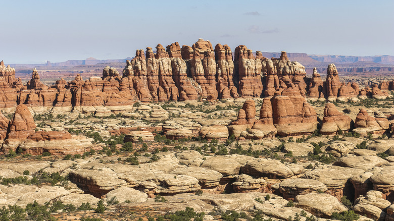
The stunning sandstone structures of Canyonlands National Park are best explored on the Chesler Park/Joint Trail Loop. It's a popular and scenic hike that covers 10.7 miles, starting at the Elephant Hill trailhead and leading to Chesler Park, a wide grassy basin surrounded by tall sandstone pinnacles. You can turn back after enjoying the park, but taking the loop is recommended. It's located in the Needles District and takes anywhere between five and seven hours and has an elevation change of 615 feet. However, you will go up and down frequently and climb more than the listed elevation gain, so it is rated strenuous.
You can hike it either way, but counterclockwise means you'll get most of the exertion out of the way at the start. This leaves you to enjoy the remainder of the trail on a gentler path with uninterrupted views of those tall, colorful sandstone towers that Needles is known for. Either way, you'll also pass through the Joint Trail, where manmade stairs descend into a deep, quarter-mile-long fracture in the rock. It's narrow, and there are some very tight sections; careful maneuvering is required. It's a year-round trail, but spring and fall offer the optimum temperatures. However, do not enter when the weather is very wet, as flash floods can pose significant risks.
8. Mesa Arch Trail (Canyonlands)
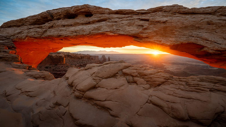
Canyonlands National Park is among the most beautiful canyons in the American West, and Mesa Arch is recommended as a must-do sunrise trail. The short, easy path on the Island in the Sky mesa delivers an iconic canyon panorama that requires minimal effort. Mesa Arch itself is a low stone arch that stretches across a cliff edge. The rising sun lights up its underside in hot orange, while a maze of buttes and the distant snow-capped La Sal Mountains are perfectly framed through its opening. It is one of the most photographed spots in southeast Utah, and photographers are always there to capture those first amber rays.
The trail is just a 0.6-mile round trip through desert terrain scattered with junipers and sandstone and climbs just 56 feet, taking about 30 minutes. Families and first-time visitors find it very accessible, though care of young ones is required due to exposed cliff edges that require careful footing. It's easier to walk to the arch in a clockwise direction before turning back the same way. This will minimize stair climbing, but if it's winter, bring traction devices, as conditions will likely make the trail slippery. Otherwise, April/May and September/October bring milder weather.
7. Observation Point via East Mesa (Zion)
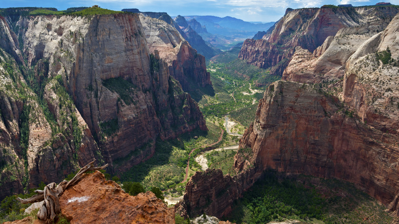
The East Mesa Trail is a 6.8-mile round trip to Observation Point. It takes just two to three hours and has a gentle climb of around 300 feet through a sparse ponderosa pine forest. The climb is manageable for families, although the middle section features fairly monotonous scenery. However, the last mile opens up to stunning views before you reach Observation Point. From the cliff edge at the end, Zion Canyon drops away into a huge stone corridor where walls rise like fortress ramparts. Below, you can see the Virgin River snaking its way through the verdant canyon floor, while the endpoint of Zion's most famous hike, Angels Landing, is also part of the incredible scenery.
Observation Point is consistently praised as having one of the park's finest views — and that gentle forest walk may be more preferable than the crowds and exposure of Angels Landing. You'll need a high-clearance four-wheel-drive vehicle to access the trailhead when it's wet. Shuttle services are available from Zion Ponderosa Ranch Resort or outfitters in Springdale if you don't have your own. You'll probably need snowshoes or crampons in winter, but it is still a very underrated time to visit Zion NP. If you hike in summer, bring protection. Temperatures are high, and shade is minimal, so go early for sunrise or late for sunset; just bring a headlamp for any evening walk back.
6. Fairyland Loop Trail (Bryce Canyon)
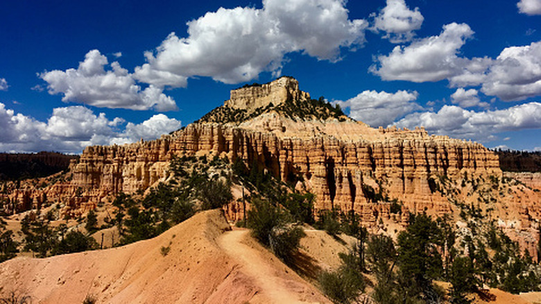
The Fairyland Loop is a longer, quieter Bryce Canyon ramble than the more popular Navajo Loop and Queen's Garden Trail. With its jagged, flame-colored spires crowding together like a stone forest, it's one of the most spectacular desert canyon hikes in Utah. Shadows pool in narrow gaps between the hoodoos, and scattered bristlecone pines cling to the slopes. It's eight miles of wonderful scenery, and many experienced hikers call it their personal favorite.
The Fairyland Loop circles the broad Bryce Amphitheater on the park's edge and takes four to five hours. However, the rapid 1,900-foot elevation gain and the long distance mean it is rated strenuous. You can start from either Fairyland Point or the Tower Bridge junction, and the NPS recommends hiking in a counterclockwise direction. However, it can be done either way, and some prefer clockwise as it's said to be more beautiful, and you can also descend rather than climb the moderately challenging Tower Bridge section. Going this way means you'll start with a 630-foot descent into Fairyland Canyon before winding through the rolling terrain around Boat Mesa, which looms high above the crowds of hoodoos like a weathered stone citadel.
About 2 or 3 miles in, Tower Bridge appears. It gets its name from the two sandstone towers connected by a horizontal rock arch, not too dissimilar to a certain London landmark. Beyond this spectacle, you'll need to climb 760 feet back to the top, then follow the quieter Rim Trail for 2.5 miles. If you're planning this trail in winter, be aware that it is often buried under 2 to 15 feet of snow and may be inaccessible. In summer, it can get hot, and shade is minimal, so starting early is a better option.
5. Devil's Garden Trail and Primitive Loop (Arches)
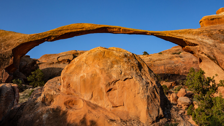
Stone bridges arching between hulking slabs are the icons at Devil's Garden. With undersides scooped smooth, framing distant fins of rock and bright blue sky, this is the lengthiest and probably hardest hike in Arches. At just about 8 miles, it can still be done in a day, but the Primitive Loop section is one of those U.S. national park trails that are only for experienced hikers. The entire loop strings no fewer than eight arches and usually takes up to four hours to complete.
It starts between two sandstone fins and reaches Landscape Arch at about a quarter mile. This is America's longest at 306 feet — and it barely holds together. It's just 6 feet at its thinnest point and looks like it may snap at any time. Beyond Landscape Arch, spur trails branch off to the grotto-like Navajo and Partition arches. Farther along, you reach Double O Arch, which features two wide openings. Nearby, you'll find a short side trail that leads to Dark Angel, a lone sandstone spire that rises from the scrub.
Just beyond Double O Arch is the Primitive Loop, a section so difficult that the NPS has seen fit to put warning signs up. Naturally, it sees fewer hikers, so if you take it on, expect adventure and solitude. You'll move across fins instead of alongside them, and you'll need to scramble through tight slots packed with boulders and polished slickrock. Private Arch is tucked between towering fins, bathed in warm afternoon glow, while sandy benches and jagged formations stretch across the final miles.
4. Navajo Loop and Queen's Garden Trail (Bryce Canyon)
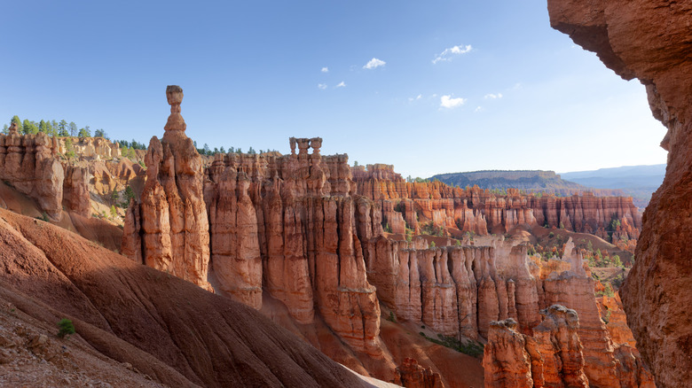
The Queen's Garden and Navajo Loop combination is possibly the most spectacular hike in Bryce Canyon National Park. It's certainly the most popular, and it's one that's recommended for first-timers. It's a short loop that drops from the canyon rim down into a staggering maze of hoodoos, giving hikers the chance to walk among these surreal formations rather than just view them from above. You'll walk along soft orange sand funneling its way between closely packed canyon walls, then wind along switchbacks carved into the labyrinth of stone spires. In winter, it's beautifully coated in a soft blanket of snow — a big contribution to Bryce Canyon being one of the best U.S. national parks to visit in the colder months.
The 2.9-mile loop takes at least two hours and climbs a total of 625 feet. You'll start at either Sunset or Sunrise Point, and the NPS recommends hiking it clockwise to avoid injuries on steep descents. Another reason is that the stunning views of Queen's Garden stay in front of you. The trail passes through echoing tunnels carved into narrow rock walls and fascinating formations, including the Queen Victoria pinnacle that appears to be wearing a crown. On the canyon floor, you'll connect to the Navajo Loop and climb steep switchbacks to Sunset Point. You can choose one of two routes to get there: the Two Bridges route is open year-round and passes Thor's Hammer, a solitary stone pillar with an improbably balanced hamme-like top rock, or Wall Street, with its narrow corridors of massive walls. The latter unfortunately closes in winter, and you'll also need microspikes for other sections of the trail at this time.
3. The Narrows, Bottom Up (Zion)
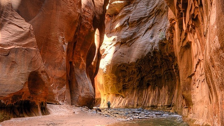
The iconic Narrows trail is an enchanting journey through nature's beauty. The bottom-up route is a shorter alternative to the 16-mile top-to-bottom hike. Most people cover 4 to 10 miles in as many hours, retracing their steps whenever they feel like it. This makes it more of a journey than a destination hike. Starting at the Temple of Sinawava, a natural amphitheater sculpted by the relentless flow of the Virgin River, the trail requires wading or swimming through the cold, fast-moving water as it squeezes its way between towering sandstone walls. The walls rise up to 1,000 feet, providing consistent shade, while golden light bounces off the wet, sculpted rock.
About 15 minutes upstream, you'll encounter Mystery Falls dropping like a narrow beaded curtain from 120 feet above. Orderville Canyon, about 2 miles farther, offers a spectacular detour. It tightens around in a twisting, echoing hallway of water and smooth rock, and you'll need to scramble and swim in parts — but it's well worth scheduling in. After returning to the main trail, the Wall Street Corridor awaits. It's the most dramatic and tallest stretch of walls before you reach Big Spring, the turnaround point for permit-free hiking. Unlike other Utah national parks, the summer heat on this trail is more bearable, thanks to the plentiful shade and cold water. However, thunderstorms can bring flash floods, so monitor weather reports. Water levels are lowest in the fall, and light conditions are favorable for photographers. In spring, the runoff keeps the water high and frigid, and you'll need a drysuit in winter.
2. Angels Landing Trail (Zion)
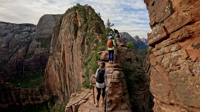
Sheer red cliffs loom over Zion Canyon with streaked and fractured faces, while the Virgin River curls its way through cottonwoods and shadows below. This is the Angels Landing Trail in Zion National Park, a bucket-list test of nerves that repeatedly ranks among the most dramatic day hikes in the world. It's a four- to five-hour, 5.4-mile round trip that climbs almost 1,500 feet starting along the river before hitting a series of steep switchbacks up to Refrigerator Canyon.
After walking the narrow path between soaring sandstone walls, you'll have to tackle the beautifully named Walter's Wiggles, a series of 21 tight switchbacks that sharply climb to Scout Lookout, where sweeping canyon views reveal the final challenge ahead. Many turn back — and it's a sensible call. What comes next demands absolute confidence. The final half-mile to Angels Landing follows an exposed ridge up the Hogsback — a narrow, steep section where chains bolted into the stone are your only security against sheer drop-offs on both sides. Anyone uncomfortable with serious exposure or heights should not attempt it. It's one of the most dangerous tourist attractions in America — a fall here would almost certainly be fatal.
If you successfully conquer Hogsback, the trail reaches Angel's Landing at 5,794 feet. From there, the canyon looks unreal. The road and river scribble in loops below at the feet of huge red walls rising in jagged waves under an enormous blue sky. Choose your season carefully to do this hike. Summer turns the exposed trail into a furnace, while winter, into early spring, can bring deadly black ice. Microspikes are essential from October through March, and you'll need a permit beyond Scout Lookout, which you can obtain through seasonal or day-before lotteries at recreation.gov.
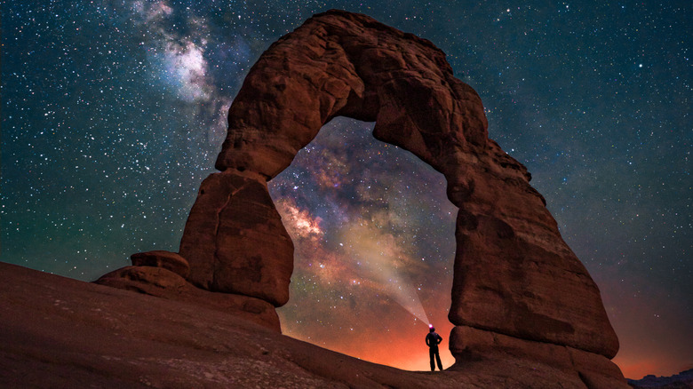
1. Delicate Arch Trail (Arches)
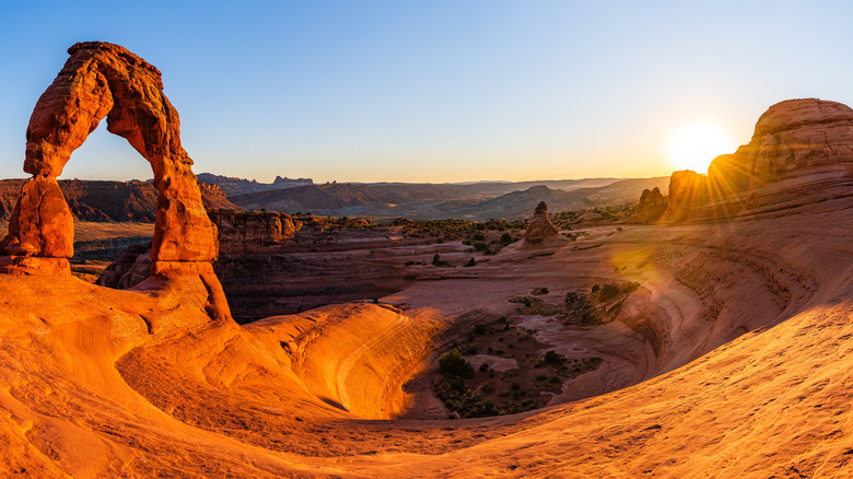
With rust-red stone rising in sweeping curves and broken shelves, Arches National Park is a stunning playground for adventurers. Bare paths thread their way upward through the scrub toward free-standing doorways of sandstone; cliffs drop down into vast open desert, and distant hikers are reduced to tiny specks under the glowing rock formations and expansive sky. Delicate Arch is the prize at the end of its namesake trail. It's a gravity-defying natural wonder so famous that it's plastered across many Utah license plates. It stands precariously poised, with the gaping hole 46 feet high and 32 feet wide. It's the largest freestanding arch in the park, and standing before it inspires quiet disbelief.
Getting to the arch involves a 3-mile round trip, climbing 480 feet over two to three hours. The trail starts with some gentle rises before hitting a steep slickrock with zero shade. Don't underestimate this section; rangers regularly pull out struggling hikers. Wear the proper attire on your feet and on your head, and bring plenty of water. After that slickrock grind, the path mellows through massive sandstone formations before you meet a real test of nerves: a 200-yard stretch along a narrow ledge pressed hard against the rock wall before the final spectacle is revealed. Rising from a natural amphitheater bowl, Delicate Arch draws hundreds of people chasing those sunsets that turn the sandstone deep orange and crimson red. Sunrise is a quieter alternative, but if you want to avoid the crowds, consider winter, though icy sections demand micro spikes. The summer heat can reach over 100 degrees Faranheit and brings the heaviest crowds, but spring delivers a more favorable balance.
Methodology
We drew on a mix of trusted travel publications (including Moon Travel Guides and Lonely Planet), outdoor outlets like Outside and 57Hours, and respected hiking blogs such as Bearfoot Theory and The World Travel Guy. We focused on the day hikes that these sources were most enthusiastic about overall and ranked them by how often and how strongly they were recommended. However, we also made sure that at least one day hike from each of the Mighty Five was included.